
| BRIGHTON BRIGHTON MI |
| |
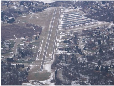
| Lat: N 4234.2 Long: W 08346.7 Elev: 973 Var: +05 Longest Runway: 3120 | ||
| CTAF: 122.9 | ||
| ||||||||||||||||||||||||||||||||
| ||||||||||||||||||||||||||||||||
| Rwy | Rwy | |||||||
| 3120x24 | 2925' | 3120x24 | 2755' | |||||
| Runway ID | Single Wheel | Double Wheel | Double Tandem Wheel | Dual Double Wheel |
| 04/22 | N/A | N/A | N/A | N/A |
| These numbers are Advisory and are not limits. The Airport Manager should have more accurate Weight Limits | ||||
| FltPlan does not have IFR approach charts available for K45G. |
| Facility Name: | BRIGHTON |
| City Name: | BRIGHTON |
| County: | LIVINGSTON |
| State abbrev: | MI |
| State Name: | MICHIGAN |
| Ownership: | PRIVATELY OWNED |
| Use: | OPEN TO THE PUBLIC |
| Owner's Name: | BRIGHTON ARPT ASSOCIATION |
| Address: | 8664 HYNE RD |
| BRIGHTON, MI 48114-8925 | |
| Owner's Phone: | 810-599-1747 |
| Manager's Name: | WILLIAM BERTRAND |
| Address: | 8664 HYNE RD |
| BRIGHTON, MI 48114-8925 | |
| Phone: | 810-599-1747 |
| FAA Region: | GREAT LAKES |
| FAA Field Office: | DET |
| Date | Sunrise | Sunset |
|---|---|---|
| 09/24/21 Friday | 7:24 | 19:29 |
| 09/25/21 Saturday | 7:25 | 19:27 |
| 09/26/21 Sunday | 7:26 | 19:26 |
| 09/27/21 Monday | 7:28 | 19:24 |
| 09/28/21 Tuesday | 7:29 | 19:22 |
| 09/29/21 Wednesday | 7:30 | 19:20 |
| 09/30/21 Thursday | 7:31 | 19:19 |
| 10/01/21 Friday | 7:32 | 19:17 |
| 10/02/21 Saturday | 7:33 | 19:15 |
| 10/03/21 Sunday | 7:34 | 19:13 |
| 10/04/21 Monday | 7:35 | 19:12 |
| 10/05/21 Tuesday | 7:36 | 19:10 |
| 10/06/21 Wednesday | 7:38 | 19:08 |
| 10/07/21 Thursday | 7:39 | 19:07 |
| Airport Attendance Schedule | 7 Days A Week IREG |
| Airport Status | OPERATIONAL (This Status can change at any time - please check NOTAMS) |
| Airport Lighting Schedule | ACTVT NSTD PAPI RWY 22; NSTD MIRL RWY 04/22 - 5 KEY CLICKS CTAF.; ACTVT ROTATING BCN - KEY MIC 5X CTAF. |
| Airport Storage Available | Tie Downs |
| Extra Services Available | NONE |
| Wind Indicator | YES - (lighted) |
| Control Tower | NO |
| CTAF Frequency | 122.900 |
| Unicom Frequency | |
| Rotating Beacon Color | CLEAR-GREEN (Light Land Airport) |
| Segmented Circle | NO |
| Landing Fee | NO |
| Airport Inspected | STATE - performed by STATE AERONAUTICAL PERSONNEL |
| Inspection Date | 06/04/2019 |
| Type of Fuel Available | None |
| Airframe Repair Service | None |
| Power Plant Repair Service | None |
| Latitude | N4234.2 |
| Longitude | W08346.7 (ESTIMATED) |
| Arpt Elevation | 973ft (SURVEYED) |
| Magnetic Variation | 05W |
| 3 miles N | of BRIGHTON |
| Traffic Pattern Altitude | |
| Sectional Chart | DETROIT |
| Operations (Reported) | Yearly | Avg. Daily |
|---|---|---|
| General Aviation Transient | 8800 | 24 |
| General Aviation Local | 8800 | 24 |
| Air Taxi | 0 | 0 |
| Commerical | 0 | 0 |
| Commuter | 0 | 0 |
| Military | 0 | 0 |
| Aircraft based on Field | |
|---|---|
| General Aviation Singles | 89 |
| General Aviation Multi | 1 |
| Jet Aircraft | 0 |
| General Aviation Helicopters | 0 |
| Military Aircraft | 0 |
| Gliders | 0 |
| Ultralights | 1 |
| FSS on field | NO |
| FSS tie-in | LANSING |
| FSS Phone | 1-800-WX-BRIEF |
| Who issues Notams | LAN |
| Notam D service at airport | YES |
| ARTCC Name | CLEVELAND |
| Airport Certification | |
| Aircraft Rescue & Firefighting Index | None |
| Airport of Entry | No |
| Custom Landing Rights | No |
| Joint Civil/Military | No |
| Military Landing rights | No |
| DEER AND LRG BIRDS ON & INVOF ARPT. |
| CALL AMGR TO VFY RWY CONDS IN WINTER. |
| CALL TO VFY SN REMOVAL. |
| FOR CD CTC DETROIT APCH AT 800-499-8181. |
| RWY 04/2 2 NSTD MIRL LGTS LCTD 50 FT FM RWY EDGE, NSTD CONFIGURATION FOR THLDS - LCL USE ONLY. |
| Runway: 04 | Runway: 22 | ||
| Mag heading: | 43° | Mag heading: | 223° |
| Rwy Slope: | .13% Up | Rwy Slope: | -.13% Down |
| Approach: | Approach: | ||
| Pattern: | Left Traffic | Pattern: | Left Traffic |
| Markings: | BASIC | Markings: | BASIC |
| Marking Condition: | GOOD | Marking Condition: | GOOD |
| Arresting Dev: | Arresting Dev: | ||
| Lat & Long: | N4234.0 W08346.9 | Lat. & Long.: | N4234.4 W08346.5 |
| Elev: | 969.0 ft. MSL | Elev: | 973.0 ft. MSL |
| TCH: | TCH: | 28 ft. AGL | |
| Visual Glide Path: | Visual Glide Path: | 3.60 degrees | |
| Displaced Threshold: | 195 feet | Displaced Threshold: | 365 feet |
| Touchdown Zone: | NO | Touchdown Zone: | NO |
| Touchdown Elev.: | Touchdown Elev.: | ||
| Visual Glide Slope: | Visual Glide Slope: | NONSTANDARD VASI SYSTEM; RWY 22 PAPI NSTD INSTALLATION - MAY ONLY BE VISIBLE ON SHORT FINAL APCH - LCL USE ONLY. | |
| RVR Equipment: | RVR Equipment: | ||
| RVV Equipment: | NO | RVV Equipment: | NO |
| Approach Lights: | Approach Lights: | ||
| REIL: | NO | REIL: | NO |
| Centerline Lights: | NO | Centerline Lights: | NO |
| Touchdown lights: | NO | Touchdown lights: | NO |
| Runway Category: | Runway with a Visual Approach | Runway Category: | Runway with a Visual Approach |
| Declared Distances: | Declared Distances: | ||
| Obstructions: | TREES | Obstructions: | TREES |
| Marked: | NOT Marked/Lighted | Marked: | NOT Marked/Lighted |
| Clearance slope: | 1:1; APCH RATIO 0:1 AT DSPLCD THLD, +50 FT TREES 100' R 0' DSTC. | Clearance slope: | 8:1; APCH RATIO 20:1 AT DSPLCD THLD, +45 FT TREES 95 FT DSTC, 105 FT L. |
| Obstruction height: | 45 feet AGL | Obstruction height: | 60 feet AGL |
| Dist. from runway: | 260 feet | Dist. from runway: | 700 feet |
| Centerline offset: | 100 left of centerline | Centerline offset: | B |
| Comments: | Comments: | PVT RD 100 FT DIST, PUB RD (+9 FT) 150 FT DIST. |
Thanks for using FltPlan.com
all rights reserved © 1999-2021 by Flight Plan LLC