| Rwy | Length | Land Dist Avail** | Approach* | | Rwy | Length | Land Dist Avail** | Approach* | | 02 | 4242x60 | 4242' | | | 20 | 4242x60 | 4042' | | | * only ILS, LOC, LDA, and SDF approaches to a specific runway are shown** For any Declared Landing Distance Available, please see A/FD or Approach plates |
| Runway Weight Capability (lbs.) more info on Runway Weight Capability | | Runway ID | Single Wheel | Double Wheel | Double Tandem Wheel | Dual Double Wheel | These numbers are Advisory and are not limits. The Airport Manager should have more accurate Weight Limits
Please email Support@FltPlan.com for further information. |
| Approach Charts FltPlan does not have IFR approaches charts available for K43U. |
|
| Customs Information ( Send updates to Support@FltPlan.com ) |
| Database effective date: 05/26/2016 |
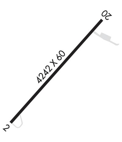
Airport Diagram might not be current.
| | Facility Name: | MOUNT PLEASANT | | City Name: | MOUNT PLEASANT | | County: | SANPETE | | State abbrev: | UT | | State Name: | UTAH | | | | | Ownership: | PUBLICLY OWNED | | Use: | OPEN TO THE PUBLIC | | Owner's Name: | CITY OF MOUNT PLEASANT | | Address: | 115 WEST MAIN ST | | | MOUNT PLEASANT, UT 84647 | | Owner's Phone: | 435-462-2456 | | | | | Manager's Name: | DAVE FULLMER | | Address: | 24920 N 9950 E | | | FAIRVIEW, UT 84629 | | Phone: | 435-262-1264 | | | | | FAA Region: | NORTHWEST MOUNTAIN | | FAA Field Office: | DEN |
| 

Click here for full scale & interactive Sectional view of K43U
|
| Sunrise / Sunset times for: MOUNT PLEASANT | | Date: | Sunrise | Sunset | | 04/22/17 Saturday | 6:39 | 20:11 | | 04/23/17 Sunday | 6:38 | 20:12 | | 04/24/17 Monday | 6:36 | 20:13 | | 04/25/17 Tuesday | 6:35 | 20:14 | | 04/26/17 Wednesday | 6:33 | 20:15 | | 04/27/17 Thursday | 6:32 | 20:16 | | 04/28/17 Friday | 6:31 | 20:17 |
| : | | Date: | Sunrise | Sunset | | 04/29/17 Saturday | 6:30 | 20:18 | | 04/30/17 Sunday | 6:28 | 20:19 | | 05/01/17 Monday | 6:27 | 20:20 | | 05/02/17 Tuesday | 6:26 | 20:21 | | 05/03/17 Wednesday | 6:25 | 20:22 | | 05/04/17 Thursday | 6:23 | 20:23 | | 05/05/17 Friday | 6:22 | 20:23 |
|
|
| Airport Facilities | Airport Attendance Schedule: UNATTENDED
Airport Status: OPERATIONAL (This Status can change at any time - please check NOTAMS)
Airport Lighting Schedule: ACTVT MIRL RY 02/20 - CTAF.
Airport Storage Available: Tie Downs
Extra Services Available: NONE
Wind Indicator: YES - (lighted)Control Tower: NO
CTAF Frequency: 122.900
Unicom Frequency: | Rotating Beacon Color: CLEAR-GREEN (Light Land Airport)
Segmented Circle: NO | | Landing Fee: NO | |
|
| Airport Services | Type of Fuel Available: None
Airframe Repair Service: None
Power Plant Repair Service: NONE |
|
| Geographic Data | | Latitude: N3931.6 Longitude: W11128.6 (ESTIMATED) | | Arpt Elevation: 5830ft (SURVEYED) | | | Magnetic Variation: 14E | | 2 miles SW of MOUNT PLEASANT | | Traffic Pattern Altitude: | | Sectional Chart: LAS VEGAS |
|
| Aircraft Data | | Operations (reported) | Yearly | Avg. Daily | | General Aviation transient: | 810 | 2 | | General Aviation Local: | 440 | 1 | | Air Taxi: | 0 | 0 | | Commerical: | 0 | 0 | | Commuter: | 0 | 0 | | Military: | 0 | 0 |
| | Aircraft based on Field | | General Aviation Singles: | 5 | | General Aviation Multi: | 0 | | Jet Aircraft: | 0 | | General Aviation Helicopters: | 0 | | Military Aircraft: | 0 | | Gliders: | 0 | | Ultralights: | 0 |
|
|
| FAA Services | FSS on field: NO
FSS tie-in:CEDAR CITY
FSS Phone: 1-800-WX-BRIEFWho issues Notams: CDC
Notam D service at airport: YES
ARTCC Name: SALT LAKE CITY | |
|
|
| Federal Status | Airport Certification:
Aircraft Rescue & Firefighting Index: NoneAirport of Entry: No
Custom Landing Rights: No | Joint Civil/Military: No
Military Landing rights: YES | |
|
|
Runway Identification: 02/20Length: 4242 ft
Width: 60 ft
Surface: ASPHALT-FAIR CONDITION
Edge lights: Medium Intensity
|
| |
| | Mag heading: | N/A | Mag heading: | N/A | | Rwy Slope: | .48% Up | Rwy Slope: | -.48% Down | | Approach: | | Approach: | | | Pattern: | Left Traffic | Pattern: | Left Traffic | | Markings: | BASIC | Markings: | BASIC | | Marking Condition: | POOR; FADED MARKINGS. NO REFLECTIVITY | Marking Condition: | POOR; FADED MARKINGS. NO REFLECTIVITY | | Arresting Dev: | | Arresting Dev: | | | Lat & Long: | N3931.3 W11128.9 | Lat. & Long.: | N3931.9 W11128.3 | | Elev: | 5810.2 ft. MSL | Elev: | 5830.4 ft. MSL | | TCH: | | TCH: | | | Visual Glide Path: | | Visual Glide Path: | | | Displaced Threshold: | No | Displaced Threshold: | 200 feet | | Touchdown Zone: | NO | Touchdown Zone: | NO | | Touchdown Elev.: | | Touchdown Elev.: | | | Visual Glide Slope: | | Visual Glide Slope: | | | RVR Equipment: | | RVR Equipment: | | | RVV Equipment: | NO | RVV Equipment: | NO | | Approach Lights: | | Approach Lights: | | | REIL: | NO | REIL: | NO | | Centerline Lights: | NO | Centerline Lights: | NO | | Touchdown lights: | NO | Touchdown lights: | NO | | Runway Category: | Runway with a Visual Approach | Runway Category: | Runway with a Visual Approach | | Declared Distances: | | Declared Distances: | | | Obstructions: | BRUSH | Obstructions: | ROAD | | Marked: | NOT Marked/Lighted | Marked: | NOT Marked/Lighted | | Clearance slope: | 1:1 | Clearance slope: | 5:1; APCH SLOPE 28:1 TO DSPLCD THLD | | Obstruction height: | 17 feet AGL | Obstruction height: | 17 feet AGL | | Dist. from runway: | 220 feet | Dist. from runway: | 290 feet | | Centerline offset: | 45 left of centerline | Centerline offset: | | | Comments: | | Comments: | |
|
| Remarks | | EXTENSIVE ULTRALIGHT AND MODEL AIRPLANE ACTIVITY ON AND INVOF ARPT.NO LINE OF SIGHT BTN RY ENDS DUE TO HUMP IN RY.RWY 02/2 0 EXTENSIVE WEED GROWTH.RWY 02 N |
|
| Airport Inspection Data | Airport Inspected: STATE - performed by STATE AERONAUTICAL PERSONNEL
Inspection Date: 08/22/2013 |
|
//
Thanks for using FltPlan.com
all rights reserved © copyright 1999-2017 by Flight Plan LLC |