
| MORGAN COUNTY MORGAN UT |
| |
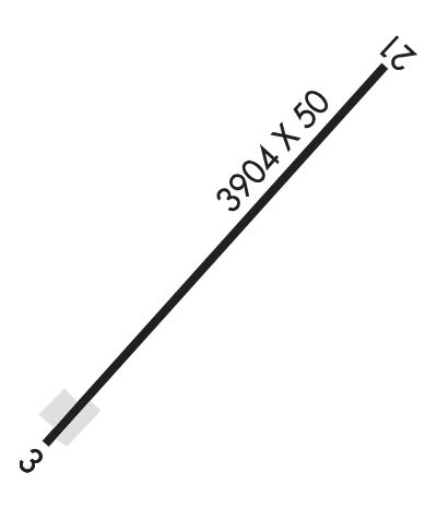
| Lat: N 4108.9 Long: W 11146.0 Elev: 5020 Var: -15 Longest Runway: 3904 | ||
| CTAF: 122.8 | ||
| ||||||||||||||||||||||||||||||||
| ||||||||||||||||||||||||||||||||
| Rwy | Rwy | |||||||
| 3904x50 | 3692' | 3904x50 | 3690' | |||||
| Runway ID | Single Wheel | Double Wheel | Double Tandem Wheel | Dual Double Wheel |
| 03/21 | N/A | N/A | N/A | N/A |
| These numbers are Advisory and are not limits. The Airport Manager should have more accurate Weight Limits | ||||
| FltPlan does not have IFR approach charts available for K42U. |
 Airport Diagram might not be current. | |
| Facility Name: | MORGAN COUNTY |
| City Name: | MORGAN |
| County: | MORGAN |
| State abbrev: | UT |
| State Name: | UTAH |
| Ownership: | PUBLICLY OWNED |
| Use: | OPEN TO THE PUBLIC |
| Owner's Name: | MORGAN COUNTY |
| Address: | 48 WEST YOUNG ST., PO BOX 886 |
| MORGAN, UT 84050 | |
| Owner's Phone: | 801-829-6811 |
| Manager's Name: | JOE GARFIELD |
| Address: | 5876 N COTTONWOOD CANYON RD, 3806 W WILLOWCREEK ROAD |
| MT. GREEN, UT 84050 | |
| Phone: | 801-821-6619 |
| FAA Region: | NORTHWEST MOUNTAIN |
| FAA Field Office: | DEN |
| Date | Sunrise | Sunset |
|---|---|---|
| 09/24/21 Friday | 7:16 | 19:21 |
| 09/25/21 Saturday | 7:17 | 19:19 |
| 09/26/21 Sunday | 7:18 | 19:18 |
| 09/27/21 Monday | 7:19 | 19:16 |
| 09/28/21 Tuesday | 7:20 | 19:14 |
| 09/29/21 Wednesday | 7:21 | 19:13 |
| 09/30/21 Thursday | 7:22 | 19:11 |
| 10/01/21 Friday | 7:24 | 19:09 |
| 10/02/21 Saturday | 7:25 | 19:08 |
| 10/03/21 Sunday | 7:26 | 19:06 |
| 10/04/21 Monday | 7:27 | 19:04 |
| 10/05/21 Tuesday | 7:28 | 19:03 |
| 10/06/21 Wednesday | 7:29 | 19:01 |
| 10/07/21 Thursday | 7:30 | 18:59 |
| Airport Attendance Schedule | UNATTENDED |
| Airport Status | OPERATIONAL (This Status can change at any time - please check NOTAMS) |
| Airport Lighting Schedule | |
| Airport Storage Available | Tie Downs |
| Extra Services Available | Glider |
| Wind Indicator | YES - (unlit) |
| Control Tower | NO |
| CTAF Frequency | 122.800 |
| Unicom Frequency | 122.800 |
| Rotating Beacon Color | |
| Segmented Circle | NO |
| Landing Fee | NO |
| Airport Inspected | STATE - performed by STATE AERONAUTICAL PERSONNEL |
| Inspection Date | 06/18/2020 |
| Type of Fuel Available | None |
| Airframe Repair Service | NONE |
| Power Plant Repair Service | NONE |
| Latitude | N4108.9 |
| Longitude | W11146.0 (ESTIMATED) |
| Arpt Elevation | 5020ft (ESTIMATED) |
| Magnetic Variation | 15E |
| 8 miles NW | of MORGAN |
| Traffic Pattern Altitude | 980 |
| Sectional Chart | SALT LAKE CITY |
| Operations (Reported) | Yearly | Avg. Daily |
|---|---|---|
| General Aviation Transient | 1068 | 3 |
| General Aviation Local | 3230 | 9 |
| Air Taxi | 20 | 0 |
| Commerical | 0 | 0 |
| Commuter | 0 | 0 |
| Military | 0 | 0 |
| Aircraft based on Field | |
|---|---|
| General Aviation Singles | 85 |
| General Aviation Multi | 2 |
| Jet Aircraft | 0 |
| General Aviation Helicopters | 3 |
| Military Aircraft | 0 |
| Gliders | 22 |
| Ultralights | 5 |
| FSS on field | NO |
| FSS tie-in | CEDAR CITY |
| FSS Phone | 1-800-WX-BRIEF |
| Who issues Notams | CDC |
| Notam D service at airport | YES |
| ARTCC Name | SALT LAKE CITY |
| Airport Certification | |
| Aircraft Rescue & Firefighting Index | None |
| Airport of Entry | No |
| Custom Landing Rights | No |
| Joint Civil/Military | No |
| Military Landing rights | YES |
| TREES, FENCES, AND HANGARS 125 FT FM CNTRLN BOTH SIDES RWY 03/21. |
| DEER AND MOOSE INVOF ARPT. |
| ITNRNT TFC USE EAST APN TIE DOWNS. |
| FOR CD CTC SALT LAKE CITY APCH AT 801-325-9670. |
| Runway: 03 | Runway: 21 | ||
| Mag heading: | N/A | Mag heading: | N/A |
| Rwy Slope: | 1.97% Up | Rwy Slope: | -1.97% Down |
| Approach: | Approach: | ||
| Pattern: | Left Traffic | Pattern: | Left Traffic |
| Markings: | BASIC | Markings: | BASIC |
| Marking Condition: | FAIR | Marking Condition: | FAIR |
| Arresting Dev: | Arresting Dev: | ||
| Lat & Long: | N4108.7 W11146.3 | Lat. & Long.: | N4109.1 W11145.7 |
| Elev: | 4943.0 ft. MSL | Elev: | 5020.0 ft. MSL |
| TCH: | TCH: | ||
| Visual Glide Path: | Visual Glide Path: | ||
| Displaced Threshold: | 212 feet | Displaced Threshold: | 214 feet |
| Touchdown Zone: | NO | Touchdown Zone: | NO |
| Touchdown Elev.: | Touchdown Elev.: | ||
| Visual Glide Slope: | Visual Glide Slope: | ||
| RVR Equipment: | RVR Equipment: | ||
| RVV Equipment: | NO | RVV Equipment: | NO |
| Approach Lights: | Approach Lights: | ||
| REIL: | NO | REIL: | NO |
| Centerline Lights: | NO | Centerline Lights: | NO |
| Touchdown lights: | NO | Touchdown lights: | NO |
| Runway Category: | Runway with a Visual Approach | Runway Category: | Runway with a Visual Approach |
| Declared Distances: | Declared Distances: | ||
| Obstructions: | ROAD | Obstructions: | TREES |
| Marked: | NOT Marked/Lighted | Marked: | NOT Marked/Lighted |
| Clearance slope: | APCH SLOPE 28:1 TO DSPLCD THLD. | Clearance slope: | APCH SLOPE 11:1 TO DSPLCD THLD. |
| Obstruction height: | 15 feet AGL | Obstruction height: | 40 feet AGL |
| Dist. from runway: | 209 feet | Dist. from runway: | 225 feet |
| Centerline offset: | B | Centerline offset: | 75 feet left of centerline |
| Comments: | 5 FT PERIMETER FENCE 120 FT FM RY END. | Comments: |
Thanks for using FltPlan.com
all rights reserved © 1999-2021 by Flight Plan LLC