
| GRAND COULEE DAM ELECTRIC CITY WA |
| |
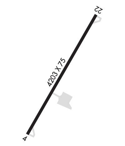
| Lat: N 4755.3 Long: W 11905.0 Elev: 1593 Var: -15 Longest Runway: 4203 | ||
| CTAF: 122.9 | ||
| ||||||||||||||||||||||||||||||||
| ||||||||||||||||||||||||||||||||
| Rwy | Rwy | |||||||
| 4203x75 | 4203' | 4203x75 | 4203' | |||||
| Runway ID | Single Wheel | Double Wheel | Double Tandem Wheel | Dual Double Wheel |
| 04/22 | 26,000 | N/A | N/A | N/A |
| These numbers are Advisory and are not limits. The Airport Manager should have more accurate Weight Limits | ||||
| FltPlan does not have IFR approach charts available for K3W7. |
 Airport Diagram might not be current. | |
| Facility Name: | GRAND COULEE DAM |
| City Name: | ELECTRIC CITY |
| County: | GRANT |
| State abbrev: | WA |
| State Name: | WASHINGTON |
| Ownership: | PUBLICLY OWNED |
| Use: | OPEN TO THE PUBLIC |
| Owner's Name: | GRANT CO PORT DIST NR 7 |
| Address: | P.O. BOX 616 |
| GRAND COULEE, WA 99133 | |
| Owner's Phone: | (509) 633-3018 |
| Manager's Name: | ROBERT BABLER |
| Address: | P.O. BOX 182 |
| GRAND COULEE, WA 99133 | |
| Phone: | 509-633-1319 |
| FAA Region: | NORTHWEST MOUNTAIN |
| FAA Field Office: | SEA |
| Date | Sunrise | Sunset |
|---|---|---|
| 09/24/21 Friday | 6:46 | 18:50 |
| 09/25/21 Saturday | 6:47 | 18:48 |
| 09/26/21 Sunday | 6:48 | 18:46 |
| 09/27/21 Monday | 6:50 | 18:44 |
| 09/28/21 Tuesday | 6:51 | 18:42 |
| 09/29/21 Wednesday | 6:52 | 18:40 |
| 09/30/21 Thursday | 6:54 | 18:38 |
| 10/01/21 Friday | 6:55 | 18:36 |
| 10/02/21 Saturday | 6:57 | 18:34 |
| 10/03/21 Sunday | 6:58 | 18:32 |
| 10/04/21 Monday | 6:59 | 18:30 |
| 10/05/21 Tuesday | 7:01 | 18:28 |
| 10/06/21 Wednesday | 7:02 | 18:26 |
| 10/07/21 Thursday | 7:04 | 18:24 |
| Airport Attendance Schedule | UNATTENDED |
| Airport Status | OPERATIONAL (This Status can change at any time - please check NOTAMS) |
| Airport Lighting Schedule | ACTVT MIRL RWY 04/22 - CTAF. |
| Airport Storage Available | Tie Downs |
| Extra Services Available | NONE |
| Wind Indicator | YES - (lighted) |
| Control Tower | NO |
| CTAF Frequency | 122.900 |
| Unicom Frequency | |
| Rotating Beacon Color | CLEAR-GREEN (Light Land Airport) |
| Segmented Circle | YES |
| Landing Fee | NO |
| Airport Inspected | STATE - performed by STATE AERONAUTICAL PERSONNEL |
| Inspection Date | 06/25/2019 |
| Type of Fuel Available | None |
| Airframe Repair Service | NONE |
| Power Plant Repair Service | NONE |
| Latitude | N4755.3 |
| Longitude | W11905.0 (ESTIMATED) |
| Arpt Elevation | 1593ft (SURVEYED) |
| Magnetic Variation | 15E |
| 2 miles SW | of ELECTRIC CITY |
| Traffic Pattern Altitude | |
| Sectional Chart | SEATTLE |
| Operations (Reported) | Yearly | Avg. Daily |
|---|---|---|
| General Aviation Transient | 8000 | 22 |
| General Aviation Local | 5000 | 14 |
| Air Taxi | 0 | 0 |
| Commerical | 0 | 0 |
| Commuter | 0 | 0 |
| Military | 0 | 0 |
| Aircraft based on Field | |
|---|---|
| General Aviation Singles | 10 |
| General Aviation Multi | 0 |
| Jet Aircraft | 0 |
| General Aviation Helicopters | 0 |
| Military Aircraft | 0 |
| Gliders | 0 |
| Ultralights | 0 |
| FSS on field | NO |
| FSS tie-in | SEATTLE |
| FSS Phone | 1-800-WX-BRIEF |
| Who issues Notams | SEA |
| Notam D service at airport | YES |
| ARTCC Name | SEATTLE |
| Airport Certification | |
| Aircraft Rescue & Firefighting Index | None |
| Airport of Entry | No |
| Custom Landing Rights | No |
| Joint Civil/Military | No |
| Military Landing rights | YES |
| NATIONAL PLAN OF INTEGRATED AIRPORT SYSTEMS (NPIAS) |
| GRANT AGREEMENTS UNDER FAAP/ADAP/AIP |
| ASSURANCES PURSUANT TO TITLE VI, CIVIL RIGHTS ACT OF 1964 |
| GEESE AND OTHER WILDLIFE INVOF RUNWAY. |
| FOR CD CTC SEATTLE ARTCC AT 253-351-3694. |
| Runway: 04 | Runway: 22 | ||
| Mag heading: | 36° | Mag heading: | 216° |
| Rwy Slope: | .01% Up | Rwy Slope: | -.01% Down |
| Approach: | Approach: | ||
| Pattern: | Left Traffic | Pattern: | Right Traffic |
| Markings: | BASIC | Markings: | BASIC |
| Marking Condition: | GOOD | Marking Condition: | GOOD |
| Arresting Dev: | Arresting Dev: | ||
| Lat & Long: | N4755.1 W11905.4 | Lat. & Long.: | N4755.5 W11904.6 |
| Elev: | 1588.7 ft. MSL | Elev: | 1589.0 ft. MSL |
| TCH: | TCH: | ||
| Visual Glide Path: | Visual Glide Path: | ||
| Displaced Threshold: | No | Displaced Threshold: | No |
| Touchdown Zone: | YES | Touchdown Zone: | YES |
| Touchdown Elev.: | 1593.1 feet | Touchdown Elev.: | 1593.1 feet |
| Visual Glide Slope: | Visual Glide Slope: | ||
| RVR Equipment: | RVR Equipment: | ||
| RVV Equipment: | NO | RVV Equipment: | NO |
| Approach Lights: | Approach Lights: | ||
| REIL: | NO | REIL: | NO |
| Centerline Lights: | NO | Centerline Lights: | NO |
| Touchdown lights: | NO | Touchdown lights: | NO |
| Runway Category: | Runway with a Visual Approach | Runway Category: | Runway with a Visual Approach |
| Declared Distances: | Declared Distances: | ||
| Obstructions: | HILL | Obstructions: | GND |
| Marked: | NOT Marked/Lighted | Marked: | NOT Marked/Lighted |
| Clearance slope: | 17:1 | Clearance slope: | 33:1 |
| Obstruction height: | 490 feet AGL | Obstruction height: | 30 feet AGL |
| Dist. from runway: | 9000 feet | Dist. from runway: | 1195 feet |
| Centerline offset: | Centerline offset: | ||
| Comments: | 15 FT TREE 61 FT FM THR, 73 FT L & DITCH 27 FT FM THR, 91 FT R. | Comments: | GND & BRUSH 43 FT FM THR, 99 FT L & SLP & BRUSH 78 FT R. |
Thanks for using FltPlan.com
all rights reserved © 1999-2021 by Flight Plan LLC
