
| MEYERS-DIVER'S TECUMSEH MI |
| |
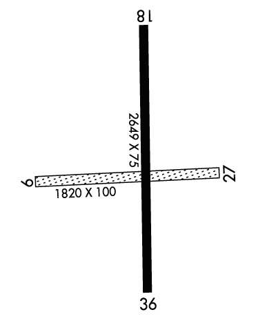
| Lat: N 4201.5 Long: W 08356.4 Elev: 812 Var: +07 Longest Runway: 2649 | ||
| CTAF: 122.9 | ||
| ||
| Rwy | Rwy | |||||||
| 1820x50 | 1820' | 1820x50 | 1820' | |||||
| 2649x75 | 2024' | 2649x75 | 2149' | |||||
| Runway ID | Single Wheel | Double Wheel | Double Tandem Wheel | Dual Double Wheel |
| 09/27 | N/A | N/A | N/A | N/A |
| 18/36 | 6,000 | N/A | N/A | N/A |
| These numbers are Advisory and are not limits. The Airport Manager should have more accurate Weight Limits | ||||
| FltPlan does not have IFR approach charts available for K3TE. |
 Airport Diagram might not be current. | |
| Facility Name: | AL MEYERS |
| City Name: | TECUMSEH |
| County: | LENAWEE |
| State abbrev: | MI |
| State Name: | MICHIGAN |
| Ownership: | PRIVATELY OWNED |
| Use: | OPEN TO THE PUBLIC |
| Owner's Name: | AL MEYERS AIRPARK, LLC |
| Address: | 4330 MACON RD |
| TECUMSEH, MI 49286-9507 | |
| Owner's Phone: | 517-423-1122 |
| Manager's Name: | ANDREW K AALTO |
| Address: | 4330 MACON RD |
| TECUMSEH, MI 49286-9507 | |
| Phone: | 517-423-1122 |
| FAA Region: | GREAT LAKES |
| FAA Field Office: | DET |
| Date | Sunrise | Sunset |
|---|---|---|
| 06/08/26 Monday | 6:00 | 21:10 |
| 06/09/26 Tuesday | 6:00 | 21:10 |
| 06/10/26 Wednesday | 6:00 | 21:11 |
| 06/11/26 Thursday | 6:00 | 21:11 |
| 06/12/26 Friday | 6:00 | 21:12 |
| 06/13/26 Saturday | 5:59 | 21:12 |
| 06/14/26 Sunday | 5:59 | 21:13 |
| 06/15/26 Monday | 5:59 | 21:13 |
| 06/16/26 Tuesday | 5:59 | 21:13 |
| 06/17/26 Wednesday | 6:00 | 21:14 |
| 06/18/26 Thursday | 6:00 | 21:14 |
| 06/19/26 Friday | 6:00 | 21:14 |
| 06/20/26 Saturday | 6:00 | 21:15 |
| 06/21/26 Sunday | 6:00 | 21:15 |
| Airport Attendance Schedule | IRREGULAR |
| Airport Status | OPERATIONAL (This Status can change at any time - please check NOTAMS) |
| Airport Lighting Schedule | ACTVT NSTD LIRL RWY 18/36 - CTAF. |
| Airport Storage Available | Tie Downs, Hanger |
| Extra Services Available | Avionics |
| Wind Indicator | YES - (lighted) |
| Control Tower | NO |
| CTAF Frequency | 122.900 |
| Unicom Frequency | |
| Rotating Beacon Color | |
| Segmented Circle | YES |
| Landing Fee | NO |
| Airport Inspected | 5010-2 PRIVATE USE MAILOUT PROGRAM - performed by STATE AERONAUTICAL PERSONNEL |
| Inspection Date | 06/27/2024 |
| Type of Fuel Available | Grade 100LL |
| Airframe Repair Service | MAJOR |
| Power Plant Repair Service | MAJOR |
| Latitude | N4201.5 |
| Longitude | W08356.4 (ESTIMATED) |
| Arpt Elevation | 812ft (ESTIMATED) |
| Magnetic Variation | 07W |
| 2 miles N | of TECUMSEH |
| Traffic Pattern Altitude | |
| Sectional Chart | DETROIT |
| Operations (Reported) | Yearly | Avg. Daily |
|---|---|---|
| General Aviation Transient | 0 | 0 |
| General Aviation Local | 0 | 0 |
| Air Taxi | 0 | 0 |
| Commerical | 0 | 0 |
| Commuter | 0 | 0 |
| Military | 0 | 0 |
| Aircraft based on Field | |
|---|---|
| General Aviation Singles | 0 |
| General Aviation Multi | 0 |
| Jet Aircraft | 0 |
| General Aviation Helicopters | 0 |
| Military Aircraft | 0 |
| Gliders | 0 |
| Ultralights | 0 |
| FSS on field | NO |
| FSS tie-in | LANSING |
| FSS Phone | 1-800-WX-BRIEF |
| Who issues Notams | LAN |
| Notam D service at airport | YES |
| ARTCC Name | CLEVELAND |
| Airport Certification | |
| Aircraft Rescue & Firefighting Index | None |
| Airport of Entry | No |
| Custom Landing Rights | No |
| Joint Civil/Military | No |
| Military Landing rights | No |
| FOR CD CTC DETROIT APCH AT 734-955-1404. |
| RWY 09/2 7 CLSD INDEFLY. |
| RWY 18/3 6 EXTSV CRACKING & VEGETATION GROWTH. |
| RWY 18/3 6 NSTD LIRL DUE TO COLOR & NON-FRANGIBLE FIXTURE TYPE; NOT FOR PUB USE. |
Airport Communications & Frequencies:
| ||||||||||||
| Runway: 09 | Runway: 27 | ||
| Mag heading: | 94° | Mag heading: | 274° |
| Rwy Slope: | .49% Up | Rwy Slope: | -.49% Down |
| Approach: | Approach: | ||
| Pattern: | Left Traffic | Pattern: | Left Traffic |
| Markings: | Markings: | ||
| Marking Condition: | Marking Condition: | ||
| Arresting Dev: | Arresting Dev: | ||
| Lat & Long: | N4201.5 W08356.6 | Lat. & Long.: | N4201.5 W08356.2 |
| Elev: | 803.0 ft. MSL | Elev: | 812.0 ft. MSL |
| TCH: | TCH: | ||
| Visual Glide Path: | Visual Glide Path: | ||
| Displaced Threshold: | No | Displaced Threshold: | No |
| Touchdown Zone: | YES | Touchdown Zone: | YES |
| Touchdown Elev.: | 812.0 feet | Touchdown Elev.: | 812.0 feet |
| Visual Glide Slope: | Visual Glide Slope: | ||
| RVR Equipment: | RVR Equipment: | ||
| RVV Equipment: | NO | RVV Equipment: | NO |
| Approach Lights: | Approach Lights: | ||
| REIL: | NO | REIL: | NO |
| Centerline Lights: | NO | Centerline Lights: | NO |
| Touchdown lights: | NO | Touchdown lights: | NO |
| Runway Category: | Runway with a Visual Approach | Runway Category: | Runway with a Visual Approach |
| Declared Distances: | Declared Distances: | ||
| Obstructions: | TREES | Obstructions: | POLE |
| Marked: | NOT Marked/Lighted | Marked: | NOT Marked/Lighted |
| Clearance slope: | 5:1 | Clearance slope: | 20:1 |
| Obstruction height: | 53 feet AGL | Obstruction height: | 5 feet AGL |
| Dist. from runway: | 267 feet | Dist. from runway: | 100 feet |
| Centerline offset: | Centerline offset: | 55 feet right of centerline | |
| Comments: | Comments: |
| Runway: 18 | Runway: 36 | ||
| Mag heading: | 186° | Mag heading: | 6° |
| Rwy Slope: | -.57% Down | Rwy Slope: | .57% Up |
| Approach: | Approach: | ||
| Pattern: | Left Traffic | Pattern: | Left Traffic |
| Markings: | BASIC | Markings: | BASIC |
| Marking Condition: | POOR; FADED. | Marking Condition: | POOR; FADED. |
| Arresting Dev: | Arresting Dev: | ||
| Lat & Long: | N4201.7 W08356.3 | Lat. & Long.: | N4201.3 W08356.3 |
| Elev: | 812.0 ft. MSL | Elev: | 797.0 ft. MSL |
| TCH: | TCH: | ||
| Visual Glide Path: | Visual Glide Path: | ||
| Displaced Threshold: | 625 feet | Displaced Threshold: | 500 feet |
| Touchdown Zone: | YES | Touchdown Zone: | YES |
| Touchdown Elev.: | 810.3 feet | Touchdown Elev.: | 812.0 feet |
| Visual Glide Slope: | Visual Glide Slope: | ||
| RVR Equipment: | RVR Equipment: | ||
| RVV Equipment: | NO | RVV Equipment: | NO |
| Approach Lights: | Approach Lights: | ||
| REIL: | NO | REIL: | NO |
| Centerline Lights: | NO | Centerline Lights: | NO |
| Touchdown lights: | NO | Touchdown lights: | NO |
| Runway Category: | Runway with a Visual Approach | Runway Category: | Runway with a Visual Approach |
| Declared Distances: | Declared Distances: | ||
| Obstructions: | TREES | Obstructions: | TREE |
| Marked: | NOT Marked/Lighted | Marked: | NOT Marked/Lighted |
| Clearance slope: | APCH RATIO 15:1 TO DTHR OVR 56 FT TREE, 860 FT DIST, 35 FT R. | Clearance slope: | 16:1; APCH RATIO 24:1 TO DTHR OVR 93 FT TREE, 2262 FT DIST, 38 FT L. |
| Obstruction height: | 51 feet AGL | Obstruction height: | 93 feet AGL |
| Dist. from runway: | 200 feet | Dist. from runway: | 1762 feet |
| Centerline offset: | 30 left of centerline | Centerline offset: | 38 feet left of centerline |
| Comments: | 20-46 FT SCT TREES, 0-199 FT DIST, 90-125 FT L. | Comments: | 17 FT ROAD, 30 FT DIST, 125 FT L/R. |
Thanks for using FltPlan.com
all rights reserved © 1999-2026 by Flight Plan LLC
