
| ROSCOMMON CONSERVATION ROSCOMMON MI |
| |
| Lat: N 4428.4 Long: W 08433.8 Elev: 1157 Var: +05 Longest Runway: 3552 | ||
| CTAF: 122.9 | ||
| ||||||||||||||||||||||||||||||||
| ||||||||||||||||||||||||||||||||
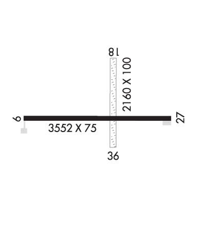
| Rwy | Rwy | |||||||
| 2500x100 | 1730' | 2500x100 | 2400' | |||||
| 3552x75 | 3402' | 3552x75 | 3552' | |||||
| Runway ID | Single Wheel | Double Wheel | Double Tandem Wheel | Dual Double Wheel |
| 01/19 | N/A | N/A | N/A | N/A |
| 10/28 | N/A | N/A | N/A | N/A |
| These numbers are Advisory and are not limits. The Airport Manager should have more accurate Weight Limits | ||||
| FltPlan does not have IFR approach charts available for K3RC. |
 Airport Diagram might not be current. | |
| Facility Name: | ROSCOMMON CONSERVATION |
| City Name: | ROSCOMMON |
| County: | ROSCOMMON |
| State abbrev: | MI |
| State Name: | MICHIGAN |
| Ownership: | PUBLICLY OWNED |
| Use: | OPEN TO THE PUBLIC |
| Owner's Name: | MI DEPT OF NATURAL RESOURCES |
| Address: | 8717 N ROSCOMMON RD |
| ROSCOMMON, MI 48653-9207 | |
| Owner's Phone: | 989-275-5151; EXTN 2722053. |
| Manager's Name: | KEVIN JACOBS |
| Address: | 8717 N ROSCOMMON RD |
| ROSCOMMON, MI 48653-9207 | |
| Phone: | 989-275-1150; EXTN 2051 FOR OFC. |
| FAA Region: | GREAT LAKES |
| FAA Field Office: | DET |
| Date | Sunrise | Sunset |
|---|---|---|
| 06/08/26 Monday | 5:54 | 21:21 |
| 06/09/26 Tuesday | 5:54 | 21:21 |
| 06/10/26 Wednesday | 5:53 | 21:22 |
| 06/11/26 Thursday | 5:53 | 21:23 |
| 06/12/26 Friday | 5:53 | 21:23 |
| 06/13/26 Saturday | 5:53 | 21:24 |
| 06/14/26 Sunday | 5:53 | 21:24 |
| 06/15/26 Monday | 5:53 | 21:25 |
| 06/16/26 Tuesday | 5:53 | 21:25 |
| 06/17/26 Wednesday | 5:53 | 21:25 |
| 06/18/26 Thursday | 5:53 | 21:26 |
| 06/19/26 Friday | 5:53 | 21:26 |
| 06/20/26 Saturday | 5:53 | 21:26 |
| 06/21/26 Sunday | 5:53 | 21:26 |
| Airport Attendance Schedule | UNATTENDED |
| Airport Status | OPERATIONAL (This Status can change at any time - please check NOTAMS) |
| Airport Lighting Schedule | ACTVT LIRL RWY 10/28 - CTAF. |
| Airport Storage Available | Tie Downs |
| Extra Services Available | NONE |
| Wind Indicator | YES - (lighted) |
| Control Tower | NO |
| CTAF Frequency | 122.900 |
| Unicom Frequency | |
| Rotating Beacon Color | |
| Segmented Circle | NO |
| Landing Fee | NO |
| Airport Inspected | STATE - performed by STATE AERONAUTICAL PERSONNEL |
| Inspection Date | 07/10/2023 |
| Type of Fuel Available | None |
| Airframe Repair Service | None |
| Power Plant Repair Service | None |
| Latitude | N4428.4 |
| Longitude | W08433.8 (ESTIMATED) |
| Arpt Elevation | 1157ft (ESTIMATED) |
| Magnetic Variation | 05W |
| 2 miles SE | of ROSCOMMON |
| Traffic Pattern Altitude | |
| Sectional Chart | LAKE HURON |
| Operations (Reported) | Yearly | Avg. Daily |
|---|---|---|
| General Aviation Transient | 0 | 0 |
| General Aviation Local | 0 | 0 |
| Air Taxi | 0 | 0 |
| Commerical | 0 | 0 |
| Commuter | 0 | 0 |
| Military | 0 | 0 |
| Aircraft based on Field | |
|---|---|
| General Aviation Singles | 0 |
| General Aviation Multi | 0 |
| Jet Aircraft | 0 |
| General Aviation Helicopters | 0 |
| Military Aircraft | 0 |
| Gliders | 0 |
| Ultralights | 0 |
| FSS on field | NO |
| FSS tie-in | LANSING |
| FSS Phone | 1-800-WX-BRIEF |
| Who issues Notams | LAN |
| Notam D service at airport | YES |
| ARTCC Name | MINNEAPOLIS |
| Airport Certification | |
| Aircraft Rescue & Firefighting Index | None |
| Airport of Entry | No |
| Custom Landing Rights | No |
| Joint Civil/Military | No |
| Military Landing rights | No |
| LRG BIRDS & LRG MAMMALS ON & INVOF ARPT. |
| FOR CD CTC MINNEAPOLIS ARTCC AT 651-463-5588. |
| RWY 01/1 9 CLSD NOV-APR & WHEN SNOW COVD. |
| RWY 01/1 9 SFC ROUGH WITH PATCHES OF GRVL. |
| Runway: 01 | Runway: 19 | ||
| Mag heading: | 5° | Mag heading: | 185° |
| Rwy Slope: | -.24% Down | Rwy Slope: | .24% Up |
| Approach: | Approach: | ||
| Pattern: | Left Traffic | Pattern: | Left Traffic |
| Markings: | Markings: | ||
| Marking Condition: | 3 FT YELLOW CONES. | Marking Condition: | 3 FT YELLOW CONES. |
| Arresting Dev: | Arresting Dev: | ||
| Lat & Long: | N4428.2 W08433.8 | Lat. & Long.: | N4428.7 W08433.8 |
| Elev: | 1157.0 ft. MSL | Elev: | 1151.0 ft. MSL |
| TCH: | TCH: | ||
| Visual Glide Path: | Visual Glide Path: | ||
| Displaced Threshold: | 770 feet | Displaced Threshold: | 100 feet |
| Touchdown Zone: | YES | Touchdown Zone: | YES |
| Touchdown Elev.: | 1157.0 feet | Touchdown Elev.: | 1157.0 feet |
| Visual Glide Slope: | Visual Glide Slope: | ||
| RVR Equipment: | RVR Equipment: | ||
| RVV Equipment: | NO | RVV Equipment: | NO |
| Approach Lights: | Approach Lights: | ||
| REIL: | NO | REIL: | NO |
| Centerline Lights: | NO | Centerline Lights: | NO |
| Touchdown lights: | NO | Touchdown lights: | NO |
| Runway Category: | Runway with a Visual Approach | Runway Category: | Runway with a Visual Approach |
| Declared Distances: | Declared Distances: | ||
| Obstructions: | TREES | Obstructions: | TREES |
| Marked: | NOT Marked/Lighted | Marked: | NOT Marked/Lighted |
| Clearance slope: | 7:1; APCH RATIO 8:1 TO DTHR OVR +10 FT TREE, 86 FT DIST, 80 FT L. | Clearance slope: | 18:1; APCH RATIO 20:1 TO DTHR. |
| Obstruction height: | 61 feet AGL | Obstruction height: | 56 feet AGL |
| Dist. from runway: | 469 feet | Dist. from runway: | 1029 feet |
| Centerline offset: | 125 right of centerline | Centerline offset: | 30 feet right of centerline |
| Comments: | Comments: |
| Runway: 10 | Runway: 28 | ||
| Mag heading: | 94° | Mag heading: | 274° |
| Rwy Slope: | -.06% Down | Rwy Slope: | .06% Up |
| Approach: | Approach: | ||
| Pattern: | Left Traffic | Pattern: | Left Traffic |
| Markings: | BASIC | Markings: | BASIC |
| Marking Condition: | GOOD | Marking Condition: | GOOD |
| Arresting Dev: | Arresting Dev: | ||
| Lat & Long: | N4428.4 W08434.3 | Lat. & Long.: | N4428.4 W08433.5 |
| Elev: | 1152.0 ft. MSL | Elev: | 1150.0 ft. MSL |
| TCH: | TCH: | ||
| Visual Glide Path: | Visual Glide Path: | ||
| Displaced Threshold: | 150 feet | Displaced Threshold: | No |
| Touchdown Zone: | YES | Touchdown Zone: | YES |
| Touchdown Elev.: | 1156.0 feet | Touchdown Elev.: | 1156.0 feet |
| Visual Glide Slope: | Visual Glide Slope: | ||
| RVR Equipment: | RVR Equipment: | ||
| RVV Equipment: | NO | RVV Equipment: | NO |
| Approach Lights: | Approach Lights: | ||
| REIL: | NO | REIL: | NO |
| Centerline Lights: | NO | Centerline Lights: | NO |
| Touchdown lights: | NO | Touchdown lights: | NO |
| Runway Category: | Runway with a Visual Approach | Runway Category: | Runway with a Visual Approach |
| Declared Distances: | Declared Distances: | ||
| Obstructions: | TREES | Obstructions: | |
| Marked: | NOT Marked/Lighted | Marked: | |
| Clearance slope: | 1:1; APCH RATIO 20:1 TO DTHR. | Clearance slope: | 20:1 |
| Obstruction height: | 30 feet AGL | Obstruction height: | |
| Dist. from runway: | 245 feet | Dist. from runway: | |
| Centerline offset: | 115 left of centerline | Centerline offset: | |
| Comments: | 15 FT ROAD, 145 FT DIST; 25 FT TREES, 178 FT DIST; 4 FT FENCE, 85 FT DIST. | Comments: |
Thanks for using FltPlan.com
all rights reserved © 1999-2026 by Flight Plan LLC
