
| JENNINGS JENNINGS LA |
| |
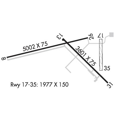
| Lat: N 3014.6 Long: W 09240.4 Elev: 23 Var: -02 Longest Runway: 5002 | ||
| AWOS: 121.15 CTAF: 122.8 | ||
| ||||||||||||||||||||||||||||||||||||||||||||
| ||||||||||||||||||||||||||||||||||||||||||||
| ||||||||||||||||||||||||||||||||||||||||||||
| ||||||||||||||||||||||||||||||||||||||||||||
| Rwy | Rwy | |||||||
| 5002x75 | 5002' | 5002x75 | 5002' | |||||
| 3601x75 | 3601' | 3601x75 | 3013' | |||||
| 1977x150 | 1977' | 1977x150 | 1977' | |||||
| Runway ID | Single Wheel | Double Wheel | Double Tandem Wheel | Dual Double Wheel |
| 08/26 | 12,000 | N/A | N/A | N/A |
| 13/31 | 12,000 | N/A | N/A | N/A |
| 17/35 | N/A | N/A | N/A | N/A |
| These numbers are Advisory and are not limits. The Airport Manager should have more accurate Weight Limits | ||||
 Airport Diagram might not be current. | |
| Facility Name: | JENNINGS |
| City Name: | JENNINGS |
| County: | JEFFERSON DAVIS |
| State abbrev: | LA |
| State Name: | LOUISIANA |
| Ownership: | PUBLICLY OWNED |
| Use: | OPEN TO THE PUBLIC |
| Owner's Name: | JEFFERSON DAVIS PARISH |
| Address: | ARPT COMMISSION DIST NR 1, P.O.BOX 745 |
| JENNINGS, LA 70546 | |
| Owner's Phone: | 337-824-1567 |
| Manager's Name: | DWAYNE BEBEE |
| Address: | P.O.BOX 877 |
| JENNINGS, LA 70546 | |
| Phone: | 337-616-2370 |
| FAA Region: | SOUTHWEST |
| FAA Field Office: | LNM |

| Date | Sunrise | Sunset |
|---|---|---|
| 03/30/26 Monday | 7:03 | 19:28 |
| 03/31/26 Tuesday | 7:01 | 19:29 |
| 04/01/26 Wednesday | 7:00 | 19:29 |
| 04/02/26 Thursday | 6:59 | 19:30 |
| 04/03/26 Friday | 6:58 | 19:31 |
| 04/04/26 Saturday | 6:57 | 19:31 |
| 04/05/26 Sunday | 6:55 | 19:32 |
| 04/06/26 Monday | 6:54 | 19:33 |
| 04/07/26 Tuesday | 6:53 | 19:33 |
| 04/08/26 Wednesday | 6:52 | 19:34 |
| 04/09/26 Thursday | 6:51 | 19:34 |
| 04/10/26 Friday | 6:50 | 19:35 |
| 04/11/26 Saturday | 6:48 | 19:36 |
| 04/12/26 Sunday | 6:47 | 19:36 |
| Airport Attendance Schedule | MON-FRI 0600-1600 |
| Airport Status | OPERATIONAL (This Status can change at any time - please check NOTAMS) |
| Airport Lighting Schedule | ACTVT MIRL RWY 08/26, RWY 13/31 - CTAF. |
| Airport Storage Available | Tie Downs, Hanger |
| Extra Services Available | Crop Dusting, Flight Instruction |
| Wind Indicator | YES - (lighted) |
| Control Tower | NO |
| CTAF Frequency | 122.800 |
| Unicom Frequency | 122.800 |
| Rotating Beacon Color | WG |
| Segmented Circle | NO |
| Landing Fee | NO |
| Airport Inspected | STATE - performed by STATE AERONAUTICAL PERSONNEL |
| Inspection Date | 06/13/2023 |
| Type of Fuel Available | Grade 100LL, JET A (freeze point -40C); -10SELF SERVICE FUEL AVBL AFT HRS WITH CREDIT CARD. |
| Airframe Repair Service | None |
| Power Plant Repair Service | None |
| Latitude | N3014.6 |
| Longitude | W09240.4 (ESTIMATED) |
| Arpt Elevation | 22ft (SURVEYED) |
| Magnetic Variation | 02E |
| 1 miles NW | of JENNINGS |
| Traffic Pattern Altitude | |
| Sectional Chart | HOUSTON |
| Operations (Reported) | Yearly | Avg. Daily |
|---|---|---|
| General Aviation Transient | 0 | 0 |
| General Aviation Local | 0 | 0 |
| Air Taxi | 0 | 0 |
| Commerical | 0 | 0 |
| Commuter | 0 | 0 |
| Military | 0 | 0 |
| Aircraft based on Field | |
|---|---|
| General Aviation Singles | 0 |
| General Aviation Multi | 0 |
| Jet Aircraft | 0 |
| General Aviation Helicopters | 0 |
| Military Aircraft | 0 |
| Gliders | 0 |
| Ultralights | 0 |
| FSS on field | NO |
| FSS tie-in | DE RIDDER |
| FSS Phone | 1-800-WX-BRIEF |
| Who issues Notams | DRI |
| Notam D service at airport | YES |
| ARTCC Name | HOUSTON |
| Airport Certification | |
| Aircraft Rescue & Firefighting Index | None |
| Airport of Entry | No |
| Custom Landing Rights | No |
| Joint Civil/Military | No |
| Military Landing rights | No |
| NATIONAL PLAN OF INTEGRATED AIRPORT SYSTEMS (NPIAS) |
| GRANT AGREEMENTS UNDER FAAP/ADAP/AIP |
| ASSURANCES PURSUANT TO TITLE VI, CIVIL RIGHTS ACT OF 1964 |
| 20 FT UNLGTD TWR 150 FT FM AER 35. |
| ULTRALIGHT ACTVTY INVOF ARPT. |
| NMRS AGRICULTURAL ACFT INVOF ARPT. |
| FOR CD CTC HOUSTON ARTCC AT 281-230-5622. |
| CTC ARPT MGR FOR RAMP SPACE DSNGD FOR PUB USE AT ARPT |
Airport Communications & Frequencies:
| |||||||||||||||||
| Runway: 08 | Runway: 26 | ||
| Mag heading: | 77° | Mag heading: | 257° |
| Rwy Slope: | .07% Up | Rwy Slope: | -.07% Down |
| Approach: | Approach: | ||
| Pattern: | Left Traffic | Pattern: | Right Traffic |
| Markings: | NONPRECISION INSTRUMENT | Markings: | NONPRECISION INSTRUMENT |
| Marking Condition: | GOOD | Marking Condition: | GOOD |
| Arresting Dev: | Arresting Dev: | ||
| Lat & Long: | N3014.5 W09241.1 | Lat. & Long.: | N3014.7 W09240.2 |
| Elev: | 16.6 ft. MSL | Elev: | 20.0 ft. MSL |
| TCH: | 50 ft. AGL | TCH: | 50 ft. AGL |
| Visual Glide Path: | 3.00 degrees | Visual Glide Path: | 3.00 degrees |
| Displaced Threshold: | No | Displaced Threshold: | No |
| Touchdown Zone: | YES | Touchdown Zone: | YES |
| Touchdown Elev.: | 17.2 feet | Touchdown Elev.: | 20.3 feet |
| Visual Glide Slope: | 2-Light PAPI on LEFT side of Runway | Visual Glide Slope: | 2-Light PAPI on LEFT side of Runway |
| RVR Equipment: | RVR Equipment: | ||
| RVV Equipment: | NO | RVV Equipment: | NO |
| Approach Lights: | Approach Lights: | ||
| REIL: | YES | REIL: | YES |
| Centerline Lights: | NO | Centerline Lights: | NO |
| Touchdown lights: | NO | Touchdown lights: | NO |
| Runway Category: | Runway with a Non-precision Approach having visibility minimums greater than 3/4 mile | Runway Category: | Runway with a Non-precision Approach having visibility minimums greater than 3/4 mile |
| Declared Distances: | Declared Distances: | ||
| Obstructions: | TREES | Obstructions: | POLE |
| Marked: | NOT Marked/Lighted | Marked: | MARKED and LIGHTED |
| Clearance slope: | 29:1 | Clearance slope: | 32:1 |
| Obstruction height: | 36 feet AGL | Obstruction height: | 37 feet AGL |
| Dist. from runway: | 1256 feet | Dist. from runway: | 1407 feet |
| Centerline offset: | 1246 left of centerline | Centerline offset: | |
| Comments: | Comments: |
| Runway: 13 | Runway: 31 | ||
| Mag heading: | 133° | Mag heading: | 313° |
| Rwy Slope: | .13% Up | Rwy Slope: | -.13% Down |
| Approach: | Approach: | ||
| Pattern: | Right Traffic | Pattern: | Left Traffic |
| Markings: | BASIC | Markings: | BASIC |
| Marking Condition: | GOOD | Marking Condition: | GOOD |
| Arresting Dev: | Arresting Dev: | ||
| Lat & Long: | N3014.7 W09240.5 | Lat. & Long.: | N3014.3 W09240.0 |
| Elev: | 18.1 ft. MSL | Elev: | 22.8 ft. MSL |
| TCH: | 50 ft. AGL | TCH: | 50 ft. AGL |
| Visual Glide Path: | 3.00 degrees | Visual Glide Path: | 3.00 degrees |
| Displaced Threshold: | No | Displaced Threshold: | 588 feet |
| Touchdown Zone: | YES | Touchdown Zone: | YES |
| Touchdown Elev.: | 22.3 feet | Touchdown Elev.: | 22.8 feet |
| Visual Glide Slope: | 2-Light PAPI on LEFT side of Runway | Visual Glide Slope: | 2-Light PAPI on LEFT side of Runway |
| RVR Equipment: | RVR Equipment: | ||
| RVV Equipment: | NO | RVV Equipment: | NO |
| Approach Lights: | Approach Lights: | ||
| REIL: | YES | REIL: | YES |
| Centerline Lights: | NO | Centerline Lights: | NO |
| Touchdown lights: | NO | Touchdown lights: | NO |
| Runway Category: | Runway with a Visual Approach | Runway Category: | Runway with a Visual Approach |
| Declared Distances: | Declared Distances: | ||
| Obstructions: | SIGN | Obstructions: | BLDG |
| Marked: | LIGHTED | Marked: | NOT Marked/Lighted |
| Clearance slope: | 21:1 | Clearance slope: | 11:1; APCH RATIO 21:1 FM DSPLCD THLD. |
| Obstruction height: | 30 feet AGL | Obstruction height: | 17 feet AGL |
| Dist. from runway: | 827 feet | Dist. from runway: | 396 feet |
| Centerline offset: | 110 right of centerline | Centerline offset: | 109 feet left of centerline |
| Comments: | Comments: | 5 FT FENCE & +15 FT ROAD 140 FT FM EOR. |
| Runway: 17 | Runway: 35 | ||
| Mag heading: | 178° | Mag heading: | 358° |
| Rwy Slope: | .01% Up | Rwy Slope: | -.01% Down |
| Approach: | Approach: | ||
| Pattern: | Right Traffic | Pattern: | Left Traffic |
| Markings: | NONE | Markings: | NONE |
| Marking Condition: | FAIR; RWY 17/35 AND THLD OUTLINED WITH ORANGE CONES. | Marking Condition: | FAIR |
| Arresting Dev: | Arresting Dev: | ||
| Lat & Long: | N3014.7 W09240.1 | Lat. & Long.: | N3014.4 W09240.1 |
| Elev: | 21.5 ft. MSL | Elev: | 21.6 ft. MSL |
| TCH: | TCH: | ||
| Visual Glide Path: | Visual Glide Path: | ||
| Displaced Threshold: | No | Displaced Threshold: | No |
| Touchdown Zone: | YES | Touchdown Zone: | YES |
| Touchdown Elev.: | 21.6 feet | Touchdown Elev.: | 21.6 feet |
| Visual Glide Slope: | Visual Glide Slope: | ||
| RVR Equipment: | RVR Equipment: | ||
| RVV Equipment: | NO | RVV Equipment: | NO |
| Approach Lights: | Approach Lights: | ||
| REIL: | NO | REIL: | NO |
| Centerline Lights: | NO | Centerline Lights: | NO |
| Touchdown lights: | NO | Touchdown lights: | NO |
| Runway Category: | Runway with a Visual Approach | Runway Category: | Runway with a Visual Approach |
| Declared Distances: | Declared Distances: | ||
| Obstructions: | POLE | Obstructions: | PLINE |
| Marked: | NOT Marked/Lighted | Marked: | LIGHTED |
| Clearance slope: | 19:1 | Clearance slope: | 30:1 |
| Obstruction height: | 35 feet AGL | Obstruction height: | 40 feet AGL |
| Dist. from runway: | 682 feet | Dist. from runway: | 1200 feet |
| Centerline offset: | Centerline offset: | ||
| Comments: | Comments: |
Thanks for using FltPlan.com
all rights reserved © 1999-2026 by Flight Plan LLC