| MOUNT HAWLEY AUXILIARY PEORIA IL |
| |
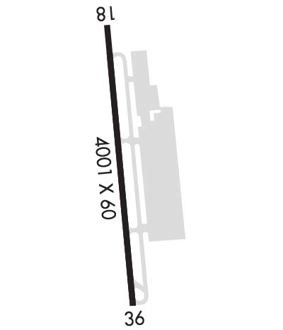
| Lat: N 4047.7 Long: W 08936.8 Elev: 793 Var: +02 Longest Runway: 4001 | ||
| Clr Del: 121.6 CTAF: 122.7 | ||
| |||||||||||||||||||||||
| |||||||||||||||||||||||
| Rwy | Rwy | |||||||
| 4001x60 | 4001' | 4001x60 | 4001' | |||||
| Runway ID | Single Wheel | Double Wheel | Double Tandem Wheel | Dual Double Wheel |
| 18/36 | 20,000 | N/A | N/A | N/A |
| These numbers are Advisory and are not limits. The Airport Manager should have more accurate Weight Limits | ||||
 Airport Diagram might not be current. | |
| Facility Name: | MOUNT HAWLEY AUXILIARY |
| City Name: | PEORIA |
| County: | PEORIA |
| State abbrev: | IL |
| State Name: | ILLINOIS |
| Ownership: | PUBLICLY OWNED |
| Use: | OPEN TO THE PUBLIC |
| Owner's Name: | METROPOLITAN AIRPORT AUTH OF PEORIA |
| Address: | GEN DOWNING PEORIA INTL ARPT, 6100 W. DIRKSEN PKWY |
| PEORIA, IL 61607 | |
| Owner's Phone: | 309-697-8272 |
| Manager's Name: | GENE OLSON |
| Address: | GEN DOWNING PEORIA INTL ARPT, 6100 W. DIRKSEN PKWY; EMAIL ADDRESS: GOLSON@FLYPIA.COM (ALL LOWER CASE) |
| PEORIA, IL 61607 | |
| Phone: | 309-697-8272; EXT 100 OR 103 CELL PHONE: 309-303-0998 |
| FAA Region: | GREAT LAKES |
| FAA Field Office: | CHI |
| Date | Sunrise | Sunset |
|---|---|---|
| 09/24/21 Friday | 6:48 | 18:53 |
| 09/25/21 Saturday | 6:49 | 18:51 |
| 09/26/21 Sunday | 6:50 | 18:49 |
| 09/27/21 Monday | 6:51 | 18:48 |
| 09/28/21 Tuesday | 6:52 | 18:46 |
| 09/29/21 Wednesday | 6:53 | 18:44 |
| 09/30/21 Thursday | 6:54 | 18:43 |
| 10/01/21 Friday | 6:55 | 18:41 |
| 10/02/21 Saturday | 6:56 | 18:39 |
| 10/03/21 Sunday | 6:57 | 18:38 |
| 10/04/21 Monday | 6:58 | 18:36 |
| 10/05/21 Tuesday | 6:59 | 18:34 |
| 10/06/21 Wednesday | 7:00 | 18:33 |
| 10/07/21 Thursday | 7:01 | 18:31 |
| Airport Attendance Schedule | 7 Days A Week DAWN-DUSK |
| Airport Status | OPERATIONAL (This Status can change at any time - please check NOTAMS) |
| Airport Lighting Schedule | ACTVT REIL & VASI RY 36.- CTAF, MIRL RWY 18/36 OPERATES SS-SR. |
| Airport Storage Available | Tie Downs, Hanger |
| Extra Services Available | Flight Instruction, Aircraft Rental, Aircraft Sales |
| Wind Indicator | YES - (lighted) |
| Control Tower | NO |
| CTAF Frequency | 122.700 |
| Unicom Frequency | 122.700 |
| Rotating Beacon Color | CLEAR-GREEN (Light Land Airport) |
| Segmented Circle | NO |
| Landing Fee | NO |
| Airport Inspected | STATE - performed by STATE AERONAUTICAL PERSONNEL |
| Inspection Date | 05/19/2020 |
| Type of Fuel Available | Grade 100LL, JET A (freeze point -40C); -1024 HOUR 100LL AND JET-A AVAILABLE WITH CREDIT CARD |
| Airframe Repair Service | MAJOR |
| Power Plant Repair Service | MAJOR |
| Latitude | N4047.7 |
| Longitude | W08936.8 (ESTIMATED) |
| Arpt Elevation | 793ft (SURVEYED) |
| Magnetic Variation | 02W |
| 7 miles N | of PEORIA |
| Traffic Pattern Altitude | |
| Sectional Chart | CHICAGO |
| Operations (Reported) | Yearly | Avg. Daily |
|---|---|---|
| General Aviation Transient | 8000 | 22 |
| General Aviation Local | 12700 | 35 |
| Air Taxi | 300 | 1 |
| Commerical | 0 | 0 |
| Commuter | 0 | 0 |
| Military | 0 | 0 |
| Aircraft based on Field | |
|---|---|
| General Aviation Singles | 45 |
| General Aviation Multi | 6 |
| Jet Aircraft | 0 |
| General Aviation Helicopters | 0 |
| Military Aircraft | 0 |
| Gliders | 0 |
| Ultralights | 0 |
| FSS on field | NO |
| FSS tie-in | KANKAKEE |
| FSS Phone | 1-800-WX-BRIEF |
| Who issues Notams | IKK |
| Notam D service at airport | YES |
| ARTCC Name | CHICAGO |
| Airport Certification | |
| Aircraft Rescue & Firefighting Index | None |
| Airport of Entry | No |
| Custom Landing Rights | No |
| Joint Civil/Military | No |
| Military Landing rights | YES |
| NATIONAL PLAN OF INTEGRATED AIRPORT SYSTEMS (NPIAS) |
| GRANT AGREEMENTS UNDER FAAP/ADAP/AIP |
| ASSURANCES PURSUANT TO TITLE VI, CIVIL RIGHTS ACT OF 1964 |
Airport Communications & Frequencies:
| ||||||||||||||||
| Runway: 18 | Runway: 36 | ||
| Mag heading: | 177° | Mag heading: | 357° |
| Rwy Slope: | -.49% Down | Rwy Slope: | .49% Up |
| Approach: | Approach: | ||
| Pattern: | Left Traffic | Pattern: | Left Traffic |
| Markings: | NONPRECISION INSTRUMENT | Markings: | BASIC |
| Marking Condition: | GOOD | Marking Condition: | GOOD |
| Arresting Dev: | Arresting Dev: | ||
| Lat & Long: | N4048.1 W08936.8 | Lat. & Long.: | N4047.4 W08936.8 |
| Elev: | 793.4 ft. MSL | Elev: | 773.6 ft. MSL |
| TCH: | TCH: | 32 ft. AGL | |
| Visual Glide Path: | Visual Glide Path: | 3.50 degrees | |
| Displaced Threshold: | No | Displaced Threshold: | No |
| Touchdown Zone: | YES | Touchdown Zone: | YES |
| Touchdown Elev.: | 793.4 feet | Touchdown Elev.: | 773.6 feet |
| Visual Glide Slope: | Visual Glide Slope: | 4-BOX VASI ON LEFT SIDE OF RUNWAY | |
| RVR Equipment: | RVR Equipment: | ||
| RVV Equipment: | NO | RVV Equipment: | NO |
| Approach Lights: | Approach Lights: | ||
| REIL: | NO | REIL: | YES |
| Centerline Lights: | NO | Centerline Lights: | NO |
| Touchdown lights: | NO | Touchdown lights: | NO |
| Runway Category: | Runway with a Non-precision Approach | Runway Category: | Runway with a Visual Approach |
| Declared Distances: | Declared Distances: |
Thanks for using FltPlan.com
all rights reserved © 1999-2021 by Flight Plan LLC