
| WARREN MUNI WARREN AR |
| |
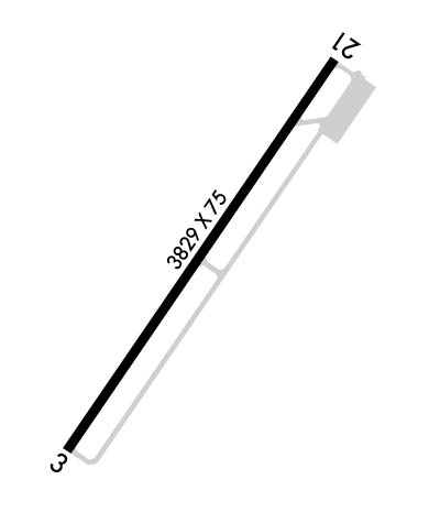
| Lat: N 3333.6 Long: W 09205.1 Elev: 235 Var: -04 Longest Runway: 3829 | ||
| CTAF: 122.9 | ||
| ||||||
|
| Rwy | Rwy | |||||||
| 3829x75 | 3829' | 3829x75 | 3829' | |||||
| Runway ID | Single Wheel | Double Wheel | Double Tandem Wheel | Dual Double Wheel |
| 03/21 | 4,000 | N/A | N/A | N/A |
| These numbers are Advisory and are not limits. The Airport Manager should have more accurate Weight Limits | ||||
 Airport Diagram might not be current. | |
| Facility Name: | WARREN MUNI |
| City Name: | WARREN |
| County: | BRADLEY |
| State abbrev: | AR |
| State Name: | ARKANSAS |
| Ownership: | PUBLICLY OWNED |
| Use: | OPEN TO THE PUBLIC |
| Owner's Name: | CITY OF WARREN |
| Address: | PO BOX 352 |
| WARREN, AR 71671 | |
| Owner's Phone: | 870-226-6743 |
| Manager's Name: | DR. JOE WHARTON; COMMISSION CHAIRMAN. |
| Address: | 10 SYLVAN HILLS DR. |
| WARREN, AR 71671 | |
| Phone: | 870-820-9119 |
| FAA Region: | SOUTHWEST |
| FAA Field Office: | AOK |
| Date | Sunrise | Sunset |
|---|---|---|
| 09/24/21 Friday | 6:58 | 19:03 |
| 09/25/21 Saturday | 6:58 | 19:01 |
| 09/26/21 Sunday | 6:59 | 19:00 |
| 09/27/21 Monday | 7:00 | 18:58 |
| 09/28/21 Tuesday | 7:00 | 18:57 |
| 09/29/21 Wednesday | 7:01 | 18:56 |
| 09/30/21 Thursday | 7:02 | 18:54 |
| 10/01/21 Friday | 7:03 | 18:53 |
| 10/02/21 Saturday | 7:03 | 18:52 |
| 10/03/21 Sunday | 7:04 | 18:50 |
| 10/04/21 Monday | 7:05 | 18:49 |
| 10/05/21 Tuesday | 7:05 | 18:48 |
| 10/06/21 Wednesday | 7:06 | 18:46 |
| 10/07/21 Thursday | 7:07 | 18:45 |
| Airport Attendance Schedule | UNATTENDED; FOR SERVICES CALL 870-226-6743 OR AFT HRS 870-226-3703. |
| Airport Status | OPERATIONAL (This Status can change at any time - please check NOTAMS) |
| Airport Lighting Schedule | ACTVT LIRL & PAPI RWY 03/21 - CTAF |
| Airport Storage Available | Tie Downs |
| Extra Services Available | NONE |
| Wind Indicator | YES - (lighted) |
| Control Tower | NO |
| CTAF Frequency | 122.900 |
| Unicom Frequency | |
| Rotating Beacon Color | CLEAR-GREEN (Light Land Airport) |
| Segmented Circle | NO |
| Landing Fee | NO |
| Airport Inspected | STATE - performed by STATE AERONAUTICAL PERSONNEL |
| Inspection Date | 08/25/2020 |
| Type of Fuel Available | Grade 100LL; -10SELF SVC FUEL AVBL 24 HRS WITH CREDIT CARD. |
| Airframe Repair Service | NONE |
| Power Plant Repair Service | NONE |
| Latitude | N3333.6 |
| Longitude | W09205.1 (ESTIMATED) |
| Arpt Elevation | 235ft (SURVEYED) |
| Magnetic Variation | 04E |
| 3 miles S | of WARREN |
| Traffic Pattern Altitude | |
| Sectional Chart | MEMPHIS |
| Operations (Reported) | Yearly | Avg. Daily |
|---|---|---|
| General Aviation Transient | 1000 | 3 |
| General Aviation Local | 3700 | 10 |
| Air Taxi | 0 | 0 |
| Commerical | 0 | 0 |
| Commuter | 0 | 0 |
| Military | 300 | 1 |
| Aircraft based on Field | |
|---|---|
| General Aviation Singles | 3 |
| General Aviation Multi | 0 |
| Jet Aircraft | 0 |
| General Aviation Helicopters | 0 |
| Military Aircraft | 0 |
| Gliders | 0 |
| Ultralights | 0 |
| FSS on field | NO |
| FSS tie-in | JONESBORO |
| FSS Phone | 1-800-WX-BRIEF |
| Who issues Notams | JBR |
| Notam D service at airport | YES |
| ARTCC Name | MEMPHIS |
| Airport Certification | |
| Aircraft Rescue & Firefighting Index | None |
| Airport of Entry | No |
| Custom Landing Rights | No |
| Joint Civil/Military | No |
| Military Landing rights | YES |
| NATIONAL PLAN OF INTEGRATED AIRPORT SYSTEMS (NPIAS) |
| GRANT AGREEMENTS UNDER FAAP/ADAP/AIP |
| ASSURANCES PURSUANT TO TITLE VI, CIVIL RIGHTS ACT OF 1964 |
| THIS AIRPORT HAS BEEN SURVEYED BY THE NATIONAL GEODETIC SURVEY. |
| DEER ON & INVOF ARPT. CTC POLICE 870-226-3703 TO CLEAR RWY. |
Airport Communications & Frequencies:
| |||||||
| Runway: 03 | Runway: 21 | ||
| Mag heading: | 30° | Mag heading: | 210° |
| Rwy Slope: | .99% Up | Rwy Slope: | -.99% Down |
| Approach: | Approach: | ||
| Pattern: | Left Traffic | Pattern: | Left Traffic |
| Markings: | NONPRECISION INSTRUMENT | Markings: | NONPRECISION INSTRUMENT |
| Marking Condition: | GOOD | Marking Condition: | GOOD |
| Arresting Dev: | Arresting Dev: | ||
| Lat & Long: | N3333.4 W09205.3 | Lat. & Long.: | N3333.9 W09204.9 |
| Elev: | 197.0 ft. MSL | Elev: | 235.0 ft. MSL |
| TCH: | 40 ft. AGL | TCH: | 40 ft. AGL |
| Visual Glide Path: | 3.00 degrees | Visual Glide Path: | 3.50 degrees |
| Displaced Threshold: | No | Displaced Threshold: | No |
| Touchdown Zone: | YES | Touchdown Zone: | YES |
| Touchdown Elev.: | 235.0 feet | Touchdown Elev.: | 235.0 feet |
| Visual Glide Slope: | 2-Light PAPI on LEFT side of Runway; PAPI UNUSBL BYD 2 DEGS LEFT OF CNTRLN. | Visual Glide Slope: | 2-Light PAPI on LEFT side of Runway; PAPI UNUSBL BYD 3 DEGS RIGHT AND LEFT OF CNTRLN. |
| RVR Equipment: | RVR Equipment: | ||
| RVV Equipment: | NO | RVV Equipment: | NO |
| Approach Lights: | Approach Lights: | ||
| REIL: | NO | REIL: | NO |
| Centerline Lights: | NO | Centerline Lights: | NO |
| Touchdown lights: | NO | Touchdown lights: | NO |
| Runway Category: | Runway with a Non-precision Approach | Runway Category: | Runway with a Visual Approach |
| Declared Distances: | Declared Distances: | ||
| Obstructions: | TREES | Obstructions: | ROAD |
| Marked: | NOT Marked/Lighted | Marked: | NOT Marked/Lighted |
| Clearance slope: | 33:1 | Clearance slope: | |
| Obstruction height: | 30 feet AGL | Obstruction height: | 10 feet AGL |
| Dist. from runway: | 1200 feet | Dist. from runway: | 201 feet |
| Centerline offset: | Centerline offset: | 170 feet left of centerline | |
| Comments: | Comments: |
Thanks for using FltPlan.com
all rights reserved © 1999-2021 by Flight Plan LLC
