
| DOUBLE SPRINGS-WINSTON COUNTY DOUBLE SPRINGS AL |
| |
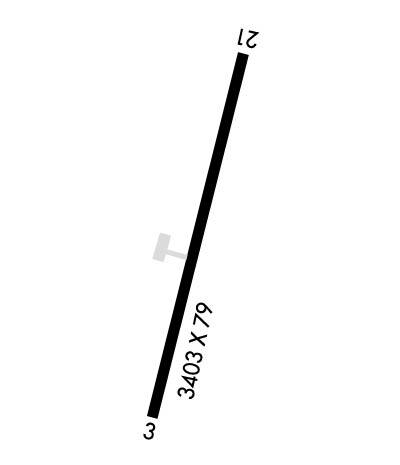
| Lat: N 3408.7 Long: W 08719.7 Elev: 754 Var: -00 Longest Runway: 3331 | ||
| CTAF: 122.9 | ||
| ||||||||||||||||||||||||||||||||
| ||||||||||||||||||||||||||||||||
| Rwy | Rwy | |||||||
| 3331x78 | 3115' | 3331x78 | 3331' | |||||
| Runway ID | Single Wheel | Double Wheel | Double Tandem Wheel | Dual Double Wheel |
| 03/21 | 15,000 | N/A | N/A | N/A |
| These numbers are Advisory and are not limits. The Airport Manager should have more accurate Weight Limits | ||||
| FltPlan does not have IFR approach charts available for K3M2. |
 Airport Diagram might not be current. | |
| Facility Name: | DOUBLE SPRINGS/WINSTON COUNTY |
| City Name: | DOUBLE SPRINGS |
| County: | WINSTON |
| State abbrev: | AL |
| State Name: | ALABAMA |
| Ownership: | PUBLICLY OWNED |
| Use: | OPEN TO THE PUBLIC |
| Owner's Name: | WINSTON COUNTY COMMISSION |
| Address: | P.O. BOX 279 |
| DOUBLE SPRINGS, AL 35553 | |
| Owner's Phone: | 205-489-5031 |
| Manager's Name: | RUSTY BANKS |
| Address: | 231 COUNTY RD 33 |
| DOUBLE SPRINGS, AL 35553 | |
| Phone: | 205-489-5318 |
| FAA Region: | SOUTHERN |
| FAA Field Office: | JAN |
| Date | Sunrise | Sunset |
|---|---|---|
| 09/24/21 Friday | 6:39 | 18:44 |
| 09/25/21 Saturday | 6:39 | 18:42 |
| 09/26/21 Sunday | 6:40 | 18:41 |
| 09/27/21 Monday | 6:41 | 18:39 |
| 09/28/21 Tuesday | 6:41 | 18:38 |
| 09/29/21 Wednesday | 6:42 | 18:37 |
| 09/30/21 Thursday | 6:43 | 18:35 |
| 10/01/21 Friday | 6:44 | 18:34 |
| 10/02/21 Saturday | 6:44 | 18:32 |
| 10/03/21 Sunday | 6:45 | 18:31 |
| 10/04/21 Monday | 6:46 | 18:30 |
| 10/05/21 Tuesday | 6:47 | 18:28 |
| 10/06/21 Wednesday | 6:47 | 18:27 |
| 10/07/21 Thursday | 6:48 | 18:26 |
| Airport Attendance Schedule | UNATTENDED |
| Airport Status | OPERATIONAL (This Status can change at any time - please check NOTAMS) |
| Airport Lighting Schedule | LGT SYS INOP. |
| Airport Storage Available | NONE |
| Extra Services Available | NONE |
| Wind Indicator | YES - (unlit) |
| Control Tower | NO |
| CTAF Frequency | 122.900 |
| Unicom Frequency | |
| Rotating Beacon Color | |
| Segmented Circle | NO |
| Landing Fee | NO |
| Airport Inspected | STATE - performed by STATE AERONAUTICAL PERSONNEL |
| Inspection Date | 07/16/2020 |
| Type of Fuel Available | None |
| Airframe Repair Service | NONE |
| Power Plant Repair Service | NONE |
| Latitude | N3408.7 |
| Longitude | W08719.7 (ESTIMATED) |
| Arpt Elevation | 753ft (SURVEYED) |
| Magnetic Variation | 00E |
| 4 miles E | of DOUBLE SPRINGS |
| Traffic Pattern Altitude | |
| Sectional Chart | ATLANTA |
| Operations (Reported) | Yearly | Avg. Daily |
|---|---|---|
| General Aviation Transient | 3335 | 9 |
| General Aviation Local | 415 | 1 |
| Air Taxi | 0 | 0 |
| Commerical | 0 | 0 |
| Commuter | 0 | 0 |
| Military | 0 | 0 |
| Aircraft based on Field | |
|---|---|
| General Aviation Singles | 0 |
| General Aviation Multi | 0 |
| Jet Aircraft | 1 |
| General Aviation Helicopters | 0 |
| Military Aircraft | 0 |
| Gliders | 0 |
| Ultralights | 0 |
| FSS on field | NO |
| FSS tie-in | ANNISTON |
| FSS Phone | 1-800-WX-BRIEF |
| Who issues Notams | ANB |
| Notam D service at airport | YES |
| ARTCC Name | MEMPHIS |
| Airport Certification | |
| Aircraft Rescue & Firefighting Index | None |
| Airport of Entry | No |
| Custom Landing Rights | No |
| Joint Civil/Military | No |
| Military Landing rights | No |
| FOR CD CTC MEMPHIS ARTCC AT 901-368-8453/8449. |
| LRG AREA OF RAMP IS UNSAFE FOR ACFT DUE TO PAVEMENT FAILURE. |
| RWY 03/2 1 WDSPR CRACKING WITH VEGETATION. |
| Runway: 03 | Runway: 21 | ||
| Mag heading: | 29° | Mag heading: | 209° |
| Rwy Slope: | -.23% Down | Rwy Slope: | .23% Up |
| Approach: | Approach: | ||
| Pattern: | Left Traffic | Pattern: | Left Traffic |
| Markings: | BASIC | Markings: | BASIC |
| Marking Condition: | FAIR | Marking Condition: | FAIR |
| Arresting Dev: | Arresting Dev: | ||
| Lat & Long: | N3408.4 W08719.8 | Lat. & Long.: | N3408.9 W08719.5 |
| Elev: | 753.6 ft. MSL | Elev: | 745.9 ft. MSL |
| TCH: | TCH: | ||
| Visual Glide Path: | Visual Glide Path: | ||
| Displaced Threshold: | 216 feet | Displaced Threshold: | No |
| Touchdown Zone: | NO | Touchdown Zone: | NO |
| Touchdown Elev.: | Touchdown Elev.: | ||
| Visual Glide Slope: | Visual Glide Slope: | ||
| RVR Equipment: | RVR Equipment: | ||
| RVV Equipment: | NO | RVV Equipment: | NO |
| Approach Lights: | Approach Lights: | ||
| REIL: | NO | REIL: | NO |
| Centerline Lights: | NO | Centerline Lights: | NO |
| Touchdown lights: | NO | Touchdown lights: | NO |
| Runway Category: | Runway with a Visual Approach | Runway Category: | Runway with a Visual Approach |
| Declared Distances: | Declared Distances: | ||
| Obstructions: | TREES | Obstructions: | |
| Marked: | NOT Marked/Lighted | Marked: | |
| Clearance slope: | 18:1 | Clearance slope: | 50:1 |
| Obstruction height: | 42 feet AGL | Obstruction height: | |
| Dist. from runway: | 992 feet | Dist. from runway: | |
| Centerline offset: | 179 right of centerline | Centerline offset: | |
| Comments: | Comments: |
Thanks for using FltPlan.com
all rights reserved © 1999-2021 by Flight Plan LLC
