
| SYRACUSE-HAMILTON COUNTY MUNI SYRACUSE KS |
| |
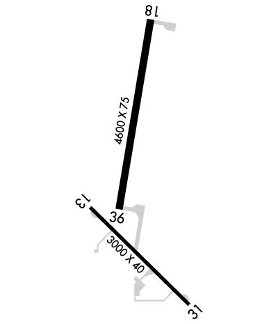
| Lat: N 3759.9 Long: W 10144.9 Elev: 3326 Var: -07 Longest Runway: 4600 | ||
| AWOS: 119.97 CTAF: 122.8 | ||
| ||||||
| ||||||
|
| Rwy | Rwy | |||||||
| 3000x40 | 3000' | 3000x40 | 2645' | |||||
| 4600x75 | 4600' | 4600x75 | 4600' | |||||
| Runway ID | Single Wheel | Double Wheel | Double Tandem Wheel | Dual Double Wheel |
| 13/31 | N/A | N/A | N/A | N/A |
| 18/36 | 30,000 | 30,000 | N/A | N/A |
| These numbers are Advisory and are not limits. The Airport Manager should have more accurate Weight Limits | ||||
 Airport Diagram might not be current. | |
| Facility Name: | SYRACUSE-HAMILTON COUNTY MUNI |
| City Name: | SYRACUSE |
| County: | HAMILTON |
| State abbrev: | KS |
| State Name: | KANSAS |
| Ownership: | PUBLICLY OWNED |
| Use: | OPEN TO THE PUBLIC |
| Owner's Name: | CITY OF SYRACUSE/HAMILTON CO |
| Address: | 109 N. MAIN ST., BOX 1136 |
| SYRACUSE, KS 67878 | |
| Owner's Phone: | 620-384-5629 |
| Manager's Name: | STEVE PHILLIPS |
| Address: | BOX 1136 |
| SYRACUSE, KS 67878 | |
| Phone: | 620-384-5435 |
| FAA Region: | CENTRAL |
| FAA Field Office: | NONE |
| Date | Sunrise | Sunset |
|---|---|---|
| 06/08/26 Monday | 5:24 | 20:08 |
| 06/09/26 Tuesday | 5:24 | 20:09 |
| 06/10/26 Wednesday | 5:24 | 20:09 |
| 06/11/26 Thursday | 5:24 | 20:09 |
| 06/12/26 Friday | 5:24 | 20:10 |
| 06/13/26 Saturday | 5:24 | 20:10 |
| 06/14/26 Sunday | 5:24 | 20:11 |
| 06/15/26 Monday | 5:24 | 20:11 |
| 06/16/26 Tuesday | 5:24 | 20:12 |
| 06/17/26 Wednesday | 5:24 | 20:12 |
| 06/18/26 Thursday | 5:24 | 20:12 |
| 06/19/26 Friday | 5:24 | 20:12 |
| 06/20/26 Saturday | 5:24 | 20:13 |
| 06/21/26 Sunday | 5:25 | 20:13 |
| Airport Attendance Schedule | INTMNT; FOR ATTENDANT AFT HRS CALL 620-384-5835 |
| Airport Status | OPERATIONAL (This Status can change at any time - please check NOTAMS) |
| Airport Lighting Schedule | DUSK-DAWN. ACTVT PAPI RWY 18 & 36, MIRL RWY 13/31, RWY 18/36 - CTAF. |
| Airport Storage Available | Tie Downs, Hanger |
| Extra Services Available | Crop Dusting |
| Wind Indicator | YES - (lighted) |
| Control Tower | NO |
| CTAF Frequency | 122.800 |
| Unicom Frequency | 122.800 |
| Rotating Beacon Color | WG |
| Segmented Circle | NO |
| Landing Fee | NO |
| Airport Inspected | STATE - performed by PRIVATE CONTRACT PERSONNEL |
| Inspection Date | 10/03/2025 |
| Type of Fuel Available | Grade 100LL |
| Airframe Repair Service | MINOR |
| Power Plant Repair Service | MINOR |
| Latitude | N3759.9 |
| Longitude | W10144.9 (ESTIMATED) |
| Arpt Elevation | 3326ft (ESTIMATED) |
| Magnetic Variation | 07E |
| 1 miles N | of SYRACUSE |
| Traffic Pattern Altitude | |
| Sectional Chart | WICHITA |
| Operations (Reported) | Yearly | Avg. Daily |
|---|---|---|
| General Aviation Transient | 0 | 0 |
| General Aviation Local | 0 | 0 |
| Air Taxi | 0 | 0 |
| Commerical | 0 | 0 |
| Commuter | 0 | 0 |
| Military | 0 | 0 |
| Aircraft based on Field | |
|---|---|
| General Aviation Singles | 0 |
| General Aviation Multi | 0 |
| Jet Aircraft | 0 |
| General Aviation Helicopters | 0 |
| Military Aircraft | 0 |
| Gliders | 0 |
| Ultralights | 0 |
| FSS on field | NO |
| FSS tie-in | WICHITA |
| FSS Phone | 1-800-WX-BRIEF |
| Who issues Notams | ICT |
| Notam D service at airport | YES |
| ARTCC Name | DENVER |
| Airport Certification | |
| Aircraft Rescue & Firefighting Index | None |
| Airport of Entry | No |
| Custom Landing Rights | No |
| Joint Civil/Military | No |
| Military Landing rights | YES |
| NATIONAL PLAN OF INTEGRATED AIRPORT SYSTEMS (NPIAS) |
| ASSURANCES PURSUANT TO TITLE VI, CIVIL RIGHTS ACT OF 1964 |
| GRANT AGREEMENT HAS EXPIRED; HOWEVER, AGREEMENT REMAINS IN EFFECT FOR THIS FACILITY AS LONG AS IT IS PUBLIC USE. |
| PUBLIC PHONE 620-384-5835. |
| FOR CD CTC DENVER ARTCC AT 303-651-4257. |
Airport Communications & Frequencies:
| |||||||||
| Runway: 13 | Runway: 31 | ||
| Mag heading: | 128° | Mag heading: | 308° |
| Rwy Slope: | -.31% Down | Rwy Slope: | .31% Up |
| Approach: | Approach: | ||
| Pattern: | Left Traffic | Pattern: | Right Traffic |
| Markings: | BASIC | Markings: | BASIC |
| Marking Condition: | FAIR | Marking Condition: | FAIR |
| Arresting Dev: | Arresting Dev: | ||
| Lat & Long: | N3759.8 W10145.1 | Lat. & Long.: | N3759.4 W10144.6 |
| Elev: | 3312.2 ft. MSL | Elev: | 3303.0 ft. MSL |
| TCH: | TCH: | ||
| Visual Glide Path: | Visual Glide Path: | ||
| Displaced Threshold: | No | Displaced Threshold: | 355 feet |
| Touchdown Zone: | YES | Touchdown Zone: | YES |
| Touchdown Elev.: | 3312.2 feet | Touchdown Elev.: | 3312.2 feet |
| Visual Glide Slope: | Visual Glide Slope: | ||
| RVR Equipment: | RVR Equipment: | ||
| RVV Equipment: | NO | RVV Equipment: | NO |
| Approach Lights: | Approach Lights: | ||
| REIL: | NO | REIL: | NO |
| Centerline Lights: | NO | Centerline Lights: | NO |
| Touchdown lights: | NO | Touchdown lights: | NO |
| Runway Category: | Runway with a Visual Approach | Runway Category: | Runway with a Visual Approach |
| Declared Distances: | Declared Distances: | ||
| Obstructions: | ROAD | Obstructions: | TREE |
| Marked: | NOT Marked/Lighted | Marked: | NOT Marked/Lighted |
| Clearance slope: | CONTROLLING OBSTN EXCEEDS A 45 DEG SLP. | Clearance slope: | OBSTN CLNC SLOPE 21:1 TO DTHR OVR 27 FT TREE, 575 FT DSTC, 87 FT L. |
| Obstruction height: | 13 feet AGL | Obstruction height: | 27 feet AGL |
| Dist. from runway: | 201 feet | Dist. from runway: | 201 feet |
| Centerline offset: | 120 left of centerline | Centerline offset: | 87 feet left of centerline |
| Comments: | Comments: | 27 FT TREE, 190 FT DSTC, 87 FT L; 15 ROAD, 199 FT DSTC 91 FT R. |
| Runway: 18 | Runway: 36 | ||
| Mag heading: | 183° | Mag heading: | 3° |
| Rwy Slope: | -.24% Down | Rwy Slope: | .24% Up |
| Approach: | Approach: | ||
| Pattern: | Right Traffic | Pattern: | Left Traffic |
| Markings: | NONPRECISION INSTRUMENT | Markings: | NONPRECISION INSTRUMENT |
| Marking Condition: | GOOD | Marking Condition: | GOOD |
| Arresting Dev: | Arresting Dev: | ||
| Lat & Long: | N3800.5 W10144.8 | Lat. & Long.: | N3759.7 W10144.9 |
| Elev: | 3326.1 ft. MSL | Elev: | 3314.9 ft. MSL |
| TCH: | 35 ft. AGL | TCH: | 44 ft. AGL |
| Visual Glide Path: | 3.00 degrees | Visual Glide Path: | 3.20 degrees |
| Displaced Threshold: | No | Displaced Threshold: | No |
| Touchdown Zone: | YES | Touchdown Zone: | YES |
| Touchdown Elev.: | 3326.1 feet | Touchdown Elev.: | 3317.5 feet |
| Visual Glide Slope: | 4-Light PAPI on RIGHT side of Runway | Visual Glide Slope: | 4-Light PAPI on LEFT side of Runway |
| RVR Equipment: | RVR Equipment: | ||
| RVV Equipment: | NO | RVV Equipment: | NO |
| Approach Lights: | Approach Lights: | ||
| REIL: | NO | REIL: | NO |
| Centerline Lights: | NO | Centerline Lights: | NO |
| Touchdown lights: | NO | Touchdown lights: | NO |
| Runway Category: | Runway with a Non-precision Approach having visibility minimums greater than 3/4 mile | Runway Category: | Runway with a Non-precision Approach having visibility minimums greater than 3/4 mile |
| Declared Distances: | Declared Distances: | ||
| Obstructions: | PLINE | Obstructions: | TOWER |
| Marked: | MARKED | Marked: | MARKED and LIGHTED |
| Clearance slope: | 20:1 | Clearance slope: | 23:1 |
| Obstruction height: | 55 feet AGL | Obstruction height: | 70 feet AGL |
| Dist. from runway: | 1327 feet | Dist. from runway: | 1870 feet |
| Centerline offset: | Centerline offset: | 350 feet right of centerline | |
| Comments: | Comments: |
Thanks for using FltPlan.com
all rights reserved © 1999-2026 by Flight Plan LLC