
| DAYTON-PHILLIPSBURG DAYTON OH |
| |
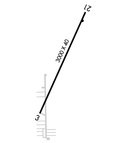
| Lat: N 3954.8 Long: W 08424.0 Elev: 1028 Var: +04 Longest Runway: 3000 | ||
| CTAF: 122.7 | ||
| ||||||||||||||||||||||||||||||||||||||||||||
| ||||||||||||||||||||||||||||||||||||||||||||
| Rwy | Rwy | |||||||
| 3000x40 | 2870' | 3000x40 | 3000' | |||||
| Runway ID | Single Wheel | Double Wheel | Double Tandem Wheel | Dual Double Wheel |
| 03/21 | N/A | N/A | N/A | N/A |
| These numbers are Advisory and are not limits. The Airport Manager should have more accurate Weight Limits | ||||
 Airport Diagram might not be current. | |
| Facility Name: | DAYTON/PHILLIPSBURG |
| City Name: | DAYTON |
| County: | MONTGOMERY |
| State abbrev: | OH |
| State Name: | OHIO |
| Ownership: | PRIVATELY OWNED |
| Use: | OPEN TO THE PUBLIC |
| Owner's Name: | DJTM HOLDINGS |
| Address: | PO BOX 10 |
| PHILLIPSBURG, OH 45354-0010 | |
| Owner's Phone: | 937-884-9795 |
| Manager's Name: | DANNY POTTER |
| Address: | PO BOX 10 |
| PHILLIPSBURG, OH 45354-0010 | |
| Phone: | 937-884-9795 |
| FAA Region: | GREAT LAKES |
| FAA Field Office: | DET |
| Date | Sunrise | Sunset |
|---|---|---|
| 06/08/26 Monday | 6:09 | 21:04 |
| 06/09/26 Tuesday | 6:09 | 21:05 |
| 06/10/26 Wednesday | 6:09 | 21:06 |
| 06/11/26 Thursday | 6:09 | 21:06 |
| 06/12/26 Friday | 6:08 | 21:06 |
| 06/13/26 Saturday | 6:08 | 21:07 |
| 06/14/26 Sunday | 6:08 | 21:07 |
| 06/15/26 Monday | 6:08 | 21:08 |
| 06/16/26 Tuesday | 6:08 | 21:08 |
| 06/17/26 Wednesday | 6:08 | 21:08 |
| 06/18/26 Thursday | 6:09 | 21:09 |
| 06/19/26 Friday | 6:09 | 21:09 |
| 06/20/26 Saturday | 6:09 | 21:09 |
| 06/21/26 Sunday | 6:09 | 21:10 |
| Airport Attendance Schedule | MON-SAT 0900-1700, SUN 1000-1700; UNATNDD NEW YEARS, EASTER, THANKSGIVING, & CHRISTMAS. |
| Airport Status | OPERATIONAL (This Status can change at any time - please check NOTAMS) |
| Airport Lighting Schedule | SS-SR |
| Airport Storage Available | Tie Downs, Hanger |
| Extra Services Available | Avionics, Flight Instruction, Aircraft Rental, Aircraft Sales |
| Wind Indicator | YES - (unlit) |
| Control Tower | NO |
| CTAF Frequency | 122.700 |
| Unicom Frequency | 122.700 |
| Rotating Beacon Color | WG |
| Segmented Circle | NO |
| Landing Fee | NO |
| Airport Inspected | STATE - performed by STATE AERONAUTICAL PERSONNEL |
| Inspection Date | 09/29/2025 |
| Type of Fuel Available | Grade 100LL, JET A (freeze point -40C); -10100LL AVBL H24 SELF SVC VIA CREDIT CARD.; -A JET A AVBL ON REQ. |
| Airframe Repair Service | MAJOR |
| Power Plant Repair Service | MAJOR |
| Latitude | N3954.8 |
| Longitude | W08424.0 (ESTIMATED) |
| Arpt Elevation | 1028ft (SURVEYED) |
| Magnetic Variation | 04W |
| 13 miles NW | of DAYTON |
| Traffic Pattern Altitude | |
| Sectional Chart | CINCINNATI |
| Operations (Reported) | Yearly | Avg. Daily |
|---|---|---|
| General Aviation Transient | 0 | 0 |
| General Aviation Local | 0 | 0 |
| Air Taxi | 0 | 0 |
| Commerical | 0 | 0 |
| Commuter | 0 | 0 |
| Military | 0 | 0 |
| Aircraft based on Field | |
|---|---|
| General Aviation Singles | 0 |
| General Aviation Multi | 0 |
| Jet Aircraft | 0 |
| General Aviation Helicopters | 0 |
| Military Aircraft | 0 |
| Gliders | 0 |
| Ultralights | 0 |
| FSS on field | NO |
| FSS tie-in | DAYTON |
| FSS Phone | 1-800-WX-BRIEF |
| Who issues Notams | DAY |
| Notam D service at airport | YES |
| ARTCC Name | INDIANAPOLIS |
| Airport Certification | |
| Aircraft Rescue & Firefighting Index | None |
| Airport of Entry | No |
| Custom Landing Rights | No |
| Joint Civil/Military | No |
| Military Landing rights | No |
| FOR CD CTC COLUMBUS APCH AT 614-338-8537. |
Airport Communications & Frequencies:
| ||||||||||||||
| Runway: 03 | Runway: 21 | ||
| Mag heading: | 28° | Mag heading: | 208° |
| Rwy Slope: | -.20% Down | Rwy Slope: | .20% Up |
| Approach: | Approach: | ||
| Pattern: | Left Traffic | Pattern: | Left Traffic |
| Markings: | NONSTANDARD | Markings: | NONSTANDARD |
| Marking Condition: | GOOD; NSTD BASIC DUE TO NRS SML SIZE & NOT LCTD AT THR; CNTRLN SPACING; DTHR WHITE LN WITH NO ARROWS. | Marking Condition: | GOOD; NSTD BASIC DUE TO NRS SML SIZE & NOT LCTD AT THR; CNTRLN SPACING. |
| Arresting Dev: | Arresting Dev: | ||
| Lat & Long: | N3954.6 W08424.2 | Lat. & Long.: | N3955.0 W08423.9 |
| Elev: | 1027.4 ft. MSL | Elev: | 1021.5 ft. MSL |
| TCH: | TCH: | ||
| Visual Glide Path: | Visual Glide Path: | ||
| Displaced Threshold: | 130 feet | Displaced Threshold: | No |
| Touchdown Zone: | YES | Touchdown Zone: | YES |
| Touchdown Elev.: | 1028.2 feet | Touchdown Elev.: | 1028.2 feet |
| Visual Glide Slope: | Visual Glide Slope: | ||
| RVR Equipment: | RVR Equipment: | ||
| RVV Equipment: | NO | RVV Equipment: | NO |
| Approach Lights: | Approach Lights: | ||
| REIL: | YES | REIL: | YES |
| Centerline Lights: | NO | Centerline Lights: | NO |
| Touchdown lights: | NO | Touchdown lights: | NO |
| Runway Category: | Runway with a Visual Approach | Runway Category: | Runway with a Visual Approach |
| Declared Distances: | Declared Distances: | ||
| Obstructions: | TREE | Obstructions: | |
| Marked: | NOT Marked/Lighted | Marked: | |
| Clearance slope: | 6:1; APCH SLP 10:1 TO DTHR. | Clearance slope: | 20:1 |
| Obstruction height: | 68 feet AGL | Obstruction height: | |
| Dist. from runway: | 650 feet | Dist. from runway: | |
| Centerline offset: | 82 left of centerline | Centerline offset: | |
| Comments: | 20 FT TWY, 0-92 FT DIST, 80-125 FT R. | Comments: | 20 FT TWY, 0-60 FT DIST, 0-250 FT R. |
Thanks for using FltPlan.com
all rights reserved © 1999-2026 by Flight Plan LLC
