
| RICHWOOD MUNI RICHWOOD WV |
| |
| Lat: N 3815.5 Long: W 08039.1 Elev: 2486 Var: +06 Longest Runway: 3360 | ||
| CTAF: 122.9 | ||
| ||||||||||||||||||||||||||||||||
| ||||||||||||||||||||||||||||||||
| Rwy | Rwy | |||||||
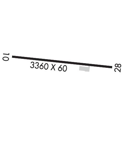
| 3360x60 | 3360' | 3360x60 | 3360' | |||||
| Runway ID | Single Wheel | Double Wheel | Double Tandem Wheel | Dual Double Wheel |
| 10/28 | N/A | N/A | N/A | N/A |
| These numbers are Advisory and are not limits. The Airport Manager should have more accurate Weight Limits | ||||
| FltPlan does not have IFR approach charts available for K3I4. |
 Airport Diagram might not be current. | |
| Facility Name: | RICHWOOD MUNI |
| City Name: | RICHWOOD |
| County: | NICHOLAS |
| State abbrev: | WV |
| State Name: | WEST VIRGINIA |
| Ownership: | PUBLICLY OWNED |
| Use: | OPEN TO THE PUBLIC |
| Owner's Name: | CITY OF RICHWOOD |
| Address: | 6 WHITE AVE |
| RICHWOOD, WV 26261 | |
| Owner's Phone: | 304-846-2596; GARY JOHNSON, MAYOR 304-562-4379; GARYJONHSONMAYOR@GMAIL.COM. |
| Manager's Name: | BOB JOHNSON |
| Address: | RICHWOOD AIRPORT AUTHORITY, 6 WHITE AVE |
| RICHWOOD, WV 26261 | |
| Phone: | 304-618-3611 |
| FAA Region: | EASTERN |
| FAA Field Office: | BKW |
| Date | Sunrise | Sunset |
|---|---|---|
| 06/08/26 Monday | 5:59 | 20:44 |
| 06/09/26 Tuesday | 5:59 | 20:45 |
| 06/10/26 Wednesday | 5:59 | 20:45 |
| 06/11/26 Thursday | 5:59 | 20:46 |
| 06/12/26 Friday | 5:59 | 20:46 |
| 06/13/26 Saturday | 5:59 | 20:47 |
| 06/14/26 Sunday | 5:59 | 20:47 |
| 06/15/26 Monday | 5:59 | 20:48 |
| 06/16/26 Tuesday | 5:59 | 20:48 |
| 06/17/26 Wednesday | 5:59 | 20:48 |
| 06/18/26 Thursday | 5:59 | 20:49 |
| 06/19/26 Friday | 5:59 | 20:49 |
| 06/20/26 Saturday | 5:59 | 20:49 |
| 06/21/26 Sunday | 5:59 | 20:49 |
| Airport Attendance Schedule | UNATTENDED |
| Airport Status | OPERATIONAL (This Status can change at any time - please check NOTAMS) |
| Airport Lighting Schedule | |
| Airport Storage Available | Tie Downs |
| Extra Services Available | NONE |
| Wind Indicator | YES - (unlit) |
| Control Tower | NO |
| CTAF Frequency | 122.900 |
| Unicom Frequency | |
| Rotating Beacon Color | |
| Segmented Circle | NO |
| Landing Fee | NO |
| Airport Inspected | STATE - performed by PRIVATE CONTRACT PERSONNEL |
| Inspection Date | 07/11/2023 |
| Type of Fuel Available | None |
| Airframe Repair Service | None |
| Power Plant Repair Service | None |
| Latitude | N3815.5 |
| Longitude | W08039.1 (ESTIMATED) |
| Arpt Elevation | 2486ft (SURVEYED) |
| Magnetic Variation | 06W |
| 6 miles W | of RICHWOOD |
| Traffic Pattern Altitude | |
| Sectional Chart | CINCINNATI |
| Operations (Reported) | Yearly | Avg. Daily |
|---|---|---|
| General Aviation Transient | 0 | 0 |
| General Aviation Local | 0 | 0 |
| Air Taxi | 0 | 0 |
| Commerical | 0 | 0 |
| Commuter | 0 | 0 |
| Military | 0 | 0 |
| Aircraft based on Field | |
|---|---|
| General Aviation Singles | 0 |
| General Aviation Multi | 0 |
| Jet Aircraft | 0 |
| General Aviation Helicopters | 0 |
| Military Aircraft | 0 |
| Gliders | 0 |
| Ultralights | 0 |
| FSS on field | NO |
| FSS tie-in | ELKINS |
| FSS Phone | 1-800-WX-BRIEF |
| Who issues Notams | EKN |
| Notam D service at airport | YES |
| ARTCC Name | WASHINGTON |
| Airport Certification | |
| Aircraft Rescue & Firefighting Index | None |
| Airport of Entry | No |
| Custom Landing Rights | No |
| Joint Civil/Military | No |
| Military Landing rights | No |
| RWY 10/28 NO SNOW REMOVAL. RWY FREQUENTLY SNOW COVERED WINTER MONTHS. |
| DEER & BIRDS ON & INVOF ARPT. |
| ARPT CLSD NIGHTS. |
| ARPT PHYS. ADDR. 3437 AIRPORT RD. RICHWOOD, WV. |
| FOR CD CTC WASHINGTON ARTCC AT 703-771-3587. |
| ARPT GATE LOCKED. CALL AMGR FOR ACCESS. |
| RWY 10/2 8 PAVEMENT CRACKS WITH VEGETATION. |
| RWY 10/2 8 1SOFT SHOULDERS. |
| Runway: 10 | Runway: 28 | ||
| Mag heading: | 102° | Mag heading: | 282° |
| Rwy Slope: | 2.08% Up | Rwy Slope: | -2.08% Down |
| Approach: | Approach: | ||
| Pattern: | Left Traffic | Pattern: | Left Traffic |
| Markings: | Markings: | BASIC | |
| Marking Condition: | FAIR | Marking Condition: | FAIR |
| Arresting Dev: | Arresting Dev: | ||
| Lat & Long: | N3815.5 W08039.4 | Lat. & Long.: | N3815.5 W08038.7 |
| Elev: | 2416.0 ft. MSL | Elev: | 2486.0 ft. MSL |
| TCH: | TCH: | ||
| Visual Glide Path: | Visual Glide Path: | ||
| Displaced Threshold: | No | Displaced Threshold: | No |
| Touchdown Zone: | NO | Touchdown Zone: | NO |
| Touchdown Elev.: | Touchdown Elev.: | ||
| Visual Glide Slope: | Visual Glide Slope: | ||
| RVR Equipment: | RVR Equipment: | ||
| RVV Equipment: | NO | RVV Equipment: | NO |
| Approach Lights: | Approach Lights: | ||
| REIL: | NO | REIL: | NO |
| Centerline Lights: | NO | Centerline Lights: | NO |
| Touchdown lights: | NO | Touchdown lights: | NO |
| Runway Category: | Runway with a Visual Approach | Runway Category: | Runway with a Visual Approach |
| Declared Distances: | Declared Distances: | ||
| Obstructions: | TREES | Obstructions: | TREES |
| Marked: | NOT Marked/Lighted | Marked: | NOT Marked/Lighted |
| Clearance slope: | 1:1 | Clearance slope: | 1:1 |
| Obstruction height: | 18 feet AGL | Obstruction height: | 70 feet AGL |
| Dist. from runway: | 222 feet | Dist. from runway: | 275 feet |
| Centerline offset: | 60 right of centerline | Centerline offset: | 140 feet right of centerline |
| Comments: | 40 FT TREES, UP TO 199 FT DSTC. | Comments: | 10 FT GND & 50 FT TREES; 30 TO 199 FT DSTC. |
Thanks for using FltPlan.com
all rights reserved © 1999-2026 by Flight Plan LLC
