| EAST KANSAS CITY GRAIN VALLEY MO |
| |
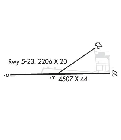
| Lat: N 3900.9 Long: W 09412.9 Elev: 835 Var: -03 Longest Runway: 4507 | ||
| Clr Del: 121.3 CTAF: 122.8 | ||
| |||||||||||||||||||||||||||||||||||||||||||||||||||||||||||||
| |||||||||||||||||||||||||||||||||||||||||||||||||||||||||||||
| Rwy | Rwy | |||||||
| 2206x20 | 2206' | 2206x20 | 2206' | |||||
| 4507x44 | 4204' | 4507x44 | 4507' | |||||
| Runway ID | Single Wheel | Double Wheel | Double Tandem Wheel | Dual Double Wheel |
| 05/23 | 11,000 | N/A | N/A | N/A |
| 09/27 | 11,000 | N/A | N/A | N/A |
| These numbers are Advisory and are not limits. The Airport Manager should have more accurate Weight Limits | ||||
 Airport Diagram might not be current. | |
| Facility Name: | EAST KANSAS CITY |
| City Name: | GRAIN VALLEY |
| County: | JACKSON |
| State abbrev: | MO |
| State Name: | MISSOURI |
| Ownership: | PRIVATELY OWNED |
| Use: | OPEN TO THE PUBLIC |
| Owner's Name: | GRAIN VALLEY AIRPORT CORP |
| Address: | BOX 255 |
| GRAIN VALLEY, MO 64029 | |
| Owner's Phone: | 816-229-8868 |
| Manager's Name: | ROBERT HACKETT |
| Address: | BOX 255, 600 EE KIRBY RD |
| GRAIN VALLEY, MO 64029 | |
| Phone: | 816-229-8868 |
| FAA Region: | CENTRAL |
| FAA Field Office: | NONE |
| Date | Sunrise | Sunset |
|---|---|---|
| 09/24/21 Friday | 7:06 | 19:11 |
| 09/25/21 Saturday | 7:07 | 19:09 |
| 09/26/21 Sunday | 7:08 | 19:08 |
| 09/27/21 Monday | 7:09 | 19:06 |
| 09/28/21 Tuesday | 7:10 | 19:05 |
| 09/29/21 Wednesday | 7:11 | 19:03 |
| 09/30/21 Thursday | 7:12 | 19:01 |
| 10/01/21 Friday | 7:13 | 19:00 |
| 10/02/21 Saturday | 7:14 | 18:58 |
| 10/03/21 Sunday | 7:14 | 18:57 |
| 10/04/21 Monday | 7:15 | 18:55 |
| 10/05/21 Tuesday | 7:16 | 18:54 |
| 10/06/21 Wednesday | 7:17 | 18:52 |
| 10/07/21 Thursday | 7:18 | 18:50 |
| Airport Attendance Schedule | 7 Days A Week 0800-DUSK |
| Airport Status | OPERATIONAL (This Status can change at any time - please check NOTAMS) |
| Airport Lighting Schedule | ACTVT REIL RWY 09; MIRL RWY 09/27 - CTAF. |
| Airport Storage Available | Tie Downs, Hanger |
| Extra Services Available | Flight Instruction, Aircraft Rental |
| Wind Indicator | YES - (lighted) |
| Control Tower | NO |
| CTAF Frequency | 122.800 |
| Unicom Frequency | 122.800 |
| Rotating Beacon Color | CLEAR-GREEN (Light Land Airport) |
| Segmented Circle | NO; R TFC INDICATORS WITH WIND TEE ONLY. |
| Landing Fee | NO |
| Airport Inspected | STATE - performed by STATE AERONAUTICAL PERSONNEL |
| Inspection Date | 07/01/2019 |
| Type of Fuel Available | Grade 100LL, JET A |
| Airframe Repair Service | MAJOR |
| Power Plant Repair Service | MAJOR |
| Latitude | N3900.9 |
| Longitude | W09412.9 (ESTIMATED) |
| Arpt Elevation | 835ft (ESTIMATED) |
| Magnetic Variation | 03E |
| 0 miles | of GRAIN VALLEY |
| Traffic Pattern Altitude | |
| Sectional Chart | KANSAS CITY |
| Operations (Reported) | Yearly | Avg. Daily |
|---|---|---|
| General Aviation Transient | 6000 | 16 |
| General Aviation Local | 15600 | 43 |
| Air Taxi | 2200 | 6 |
| Commerical | 0 | 0 |
| Commuter | 0 | 0 |
| Military | 120 | 0 |
| Aircraft based on Field | |
|---|---|
| General Aviation Singles | 185 |
| General Aviation Multi | 15 |
| Jet Aircraft | 0 |
| General Aviation Helicopters | 1 |
| Military Aircraft | 0 |
| Gliders | 0 |
| Ultralights | 0 |
| FSS on field | NO |
| FSS tie-in | COLUMBIA |
| FSS Phone | 1-800-WX-BRIEF |
| Who issues Notams | COU |
| Notam D service at airport | YES |
| ARTCC Name | KANSAS CITY |
| Airport Certification | |
| Aircraft Rescue & Firefighting Index | None |
| Airport of Entry | No |
| Custom Landing Rights | No |
| Joint Civil/Military | No |
| Military Landing rights | YES |
| WATERFOWL ON & INVOF ARPT. |
| NTSD RWY SAFETY AREA ALL RWY ENDS; INSUFFICIENT LENGTHS & INCORRECT TRRN GRADES; NO RWY SAFETY AREA BYD RWY 05 & 27. |
| FOR CD CTC KANSAS CITY APCH AT 816-329-2710. |
| RWY 05/2 3 STEEP SLOPE 60-235 FT NE OF RWY 05 THR. |
| RWY 05/2 3 WIDTH VARIANCE 20-25 FT. |
| RWY 09/2 7 WIDTH VARIANCE 44-45 FT. |
| RWY 09/2 7 NSTD MIRL; NO YELLOW EDGE LGTS LAST 2000 FT BOTH ENDS; ALL EDGE LGTS LCTD 13-15 FT FM PAVEMENT EDGE; RWY 27 ONLY 6 THR LGTS LCTD 18-20 FT E OF THR. |
Airport Communications & Frequencies:
| ||||||||||||||||
| Runway: 05 | Runway: 23 | ||
| Mag heading: | 54° | Mag heading: | 234° |
| Rwy Slope: | .69% Up | Rwy Slope: | -.69% Down |
| Approach: | Approach: | ||
| Pattern: | Left Traffic | Pattern: | Right Traffic |
| Markings: | BASIC | Markings: | BASIC |
| Marking Condition: | GOOD | Marking Condition: | GOOD |
| Arresting Dev: | Arresting Dev: | ||
| Lat & Long: | N3900.8 W09413.0 | Lat. & Long.: | N3901.0 W09412.6 |
| Elev: | 818.1 ft. MSL | Elev: | 833.4 ft. MSL |
| TCH: | TCH: | ||
| Visual Glide Path: | Visual Glide Path: | ||
| Displaced Threshold: | No | Displaced Threshold: | No |
| Touchdown Zone: | YES | Touchdown Zone: | YES |
| Touchdown Elev.: | 833.4 feet | Touchdown Elev.: | 833.4 feet |
| Visual Glide Slope: | Visual Glide Slope: | ||
| RVR Equipment: | RVR Equipment: | ||
| RVV Equipment: | NO | RVV Equipment: | NO |
| Approach Lights: | Approach Lights: | ||
| REIL: | NO | REIL: | NO |
| Centerline Lights: | NO | Centerline Lights: | NO |
| Touchdown lights: | NO | Touchdown lights: | NO |
| Runway Category: | Runway with a Visual Approach | Runway Category: | Runway with a Non-precision Approach |
| Declared Distances: | Declared Distances: | ||
| Obstructions: | RR | Obstructions: | TREE |
| Marked: | NOT Marked/Lighted | Marked: | NOT Marked/Lighted |
| Clearance slope: | 1:1 | Clearance slope: | 8:1 |
| Obstruction height: | 20 feet AGL | Obstruction height: | 53 feet AGL |
| Dist. from runway: | 225 feet | Dist. from runway: | 656 feet |
| Centerline offset: | 107 right of centerline | Centerline offset: | 207 feet right of centerline |
| Comments: | Comments: |
| Runway: 09 | Runway: 27 | ||
| Mag heading: | 88° | Mag heading: | 268° |
| Rwy Slope: | .02% Up | Rwy Slope: | -.02% Down |
| Approach: | Approach: | ||
| Pattern: | Right Traffic | Pattern: | Left Traffic |
| Markings: | NONPRECISION INSTRUMENT | Markings: | NONPRECISION INSTRUMENT |
| Marking Condition: | GOOD | Marking Condition: | GOOD |
| Arresting Dev: | Arresting Dev: | ||
| Lat & Long: | N3900.9 W09413.4 | Lat. & Long.: | N3900.8 W09412.5 |
| Elev: | 817.0 ft. MSL | Elev: | 817.9 ft. MSL |
| TCH: | TCH: | ||
| Visual Glide Path: | Visual Glide Path: | ||
| Displaced Threshold: | 303 feet; NSTD MKD DSPLCD THR; SMALL ARROW HEAD & INCORRECT SPACED ARROWS & THR BAR. | Displaced Threshold: | No |
| Touchdown Zone: | YES | Touchdown Zone: | YES |
| Touchdown Elev.: | 818.4 feet | Touchdown Elev.: | 818.4 feet |
| Visual Glide Slope: | Visual Glide Slope: | ||
| RVR Equipment: | RVR Equipment: | ||
| RVV Equipment: | NO | RVV Equipment: | NO |
| Approach Lights: | Approach Lights: | ||
| REIL: | YES | REIL: | NO |
| Centerline Lights: | NO | Centerline Lights: | NO |
| Touchdown lights: | NO | Touchdown lights: | NO |
| Runway Category: | Runway with a Non-precision Approach | Runway Category: | Runway with a Non-precision Approach |
| Declared Distances: | Declared Distances: | ||
| Obstructions: | RR | Obstructions: | RR |
| Marked: | NOT Marked/Lighted | Marked: | NOT Marked/Lighted |
| Clearance slope: | 0:1 TO DSPLCD THLD; +1-5 FT GND 0-90 FT FM RWY END 70-130 FT R. | Clearance slope: | |
| Obstruction height: | 20 feet AGL | Obstruction height: | 20 feet AGL |
| Dist. from runway: | 200 feet | Dist. from runway: | 200 feet |
| Centerline offset: | 200 right of centerline | Centerline offset: | 190 feet left of centerline |
| Comments: | 1-20 FT GND 0-200 FT FM RWY END L & R; +16 FT SIGNS 165 FT FM RWY END 80 FT L; 10-25 FT ROAD 0-200 FT FM RWY END 125-160 FT L; +18 FT TREES & BRUSH 60-70 FT FM RWY END 63-90 FT R; +1-50 FT TREES & RR 0-200 FT FM RWY END 200-250 FT R. | Comments: | +1-33 FT BRUSH; TREES; FENCE; RR; ROAD & BLDGS 0-200 FT FM RWY END L & R. |
Thanks for using FltPlan.com
all rights reserved © 1999-2021 by Flight Plan LLC