
| GRAND HAVEN MEML AIRPARK GRAND HAVEN MI |
| |
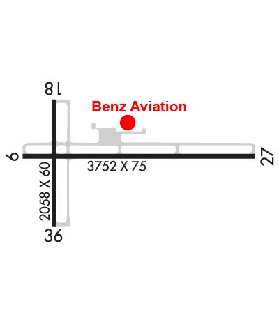
| Lat: N 4302.0 Long: W 08611.9 Elev: 604 Var: +05 Longest Runway: 3752 | ||
| CTAF: 122.7 | ||
| ||||||
|
| Rwy | Rwy | |||||||
| 3752x75 | 3752' | 3752x75 | 3752' | |||||
| 2058x60 | 2058' | 2058x60 | 2058' | |||||
| Runway ID | Single Wheel | Double Wheel | Double Tandem Wheel | Dual Double Wheel |
| 09/27 | 8,000 | N/A | N/A | N/A |
| 18/36 | 8,000 | N/A | N/A | N/A |
| These numbers are Advisory and are not limits. The Airport Manager should have more accurate Weight Limits | ||||
 Airport Diagram might not be current. | |
| Facility Name: | GRAND HAVEN MEML AIRPARK |
| City Name: | GRAND HAVEN |
| County: | OTTAWA |
| State abbrev: | MI |
| State Name: | MICHIGAN |
| Ownership: | PUBLICLY OWNED |
| Use: | OPEN TO THE PUBLIC |
| Owner's Name: | CITY OF GRAND HAVEN |
| Address: | 519 WASHINGTON AVE |
| GRAND HAVEN, MI 49417-1454 | |
| Owner's Phone: | 616-842-3220 |
| Manager's Name: | EARLE BARES |
| Address: | 16446 COMSTOCK ST |
| GRAND HAVEN, MI 49417-9423 | |
| Phone: | 616-842-4430; CELL 616-502-6773 FOR AFT HRS SER & FLD CONDS. |
| FAA Region: | GREAT LAKES |
| FAA Field Office: | DET |
| Date | Sunrise | Sunset |
|---|---|---|
| 09/24/21 Friday | 7:34 | 19:39 |
| 09/25/21 Saturday | 7:35 | 19:37 |
| 09/26/21 Sunday | 7:36 | 19:35 |
| 09/27/21 Monday | 7:37 | 19:34 |
| 09/28/21 Tuesday | 7:38 | 19:32 |
| 09/29/21 Wednesday | 7:40 | 19:30 |
| 09/30/21 Thursday | 7:41 | 19:28 |
| 10/01/21 Friday | 7:42 | 19:26 |
| 10/02/21 Saturday | 7:43 | 19:25 |
| 10/03/21 Sunday | 7:44 | 19:23 |
| 10/04/21 Monday | 7:45 | 19:21 |
| 10/05/21 Tuesday | 7:46 | 19:19 |
| 10/06/21 Wednesday | 7:48 | 19:18 |
| 10/07/21 Thursday | 7:49 | 19:16 |
| Airport Attendance Schedule | 7 Days A Week 0800-1700; UNATNDD MAJOR HOLS. |
| Airport Status | OPERATIONAL (This Status can change at any time - please check NOTAMS) |
| Airport Lighting Schedule | ACTVT REIL RWY 09 & 27; PAPI RWY 09 & 27; MIRL RWY 09/27 & 18/36 - CTAF. |
| Airport Storage Available | Tie Downs, Hanger |
| Extra Services Available | NONE |
| Wind Indicator | YES - (lighted) |
| Control Tower | NO |
| CTAF Frequency | 122.700 |
| Unicom Frequency | 122.700 |
| Rotating Beacon Color | CLEAR-GREEN (Light Land Airport) |
| Segmented Circle | YES |
| Landing Fee | NO |
| Airport Inspected | STATE - performed by STATE AERONAUTICAL PERSONNEL |
| Inspection Date | 07/31/2019 |
| Type of Fuel Available | Grade 100LL; -10FUEL AVBL H24 SELF SER VIA CREDIT CARD. |
| Airframe Repair Service | MAJOR |
| Power Plant Repair Service | MAJOR |
| Latitude | N4302.0 |
| Longitude | W08611.9 (ESTIMATED) |
| Arpt Elevation | 603ft (SURVEYED) |
| Magnetic Variation | 05W |
| 2 miles SE | of GRAND HAVEN |
| Traffic Pattern Altitude | |
| Sectional Chart | CHICAGO |
| Operations (Reported) | Yearly | Avg. Daily |
|---|---|---|
| General Aviation Transient | 4518 | 12 |
| General Aviation Local | 5304 | 15 |
| Air Taxi | 0 | 0 |
| Commerical | 0 | 0 |
| Commuter | 0 | 0 |
| Military | 50 | 0 |
| Aircraft based on Field | |
|---|---|
| General Aviation Singles | 54 |
| General Aviation Multi | 3 |
| Jet Aircraft | 0 |
| General Aviation Helicopters | 1 |
| Military Aircraft | 0 |
| Gliders | 0 |
| Ultralights | 0 |
| FSS on field | NO |
| FSS tie-in | LANSING |
| FSS Phone | 1-800-WX-BRIEF |
| Who issues Notams | LAN |
| Notam D service at airport | YES |
| ARTCC Name | CHICAGO |
| Airport Certification | |
| Aircraft Rescue & Firefighting Index | None |
| Airport of Entry | No |
| Custom Landing Rights | No |
| Joint Civil/Military | No |
| Military Landing rights | YES |
| NATIONAL PLAN OF INTEGRATED AIRPORT SYSTEMS (NPIAS) |
| GRANT AGREEMENTS UNDER FAAP/ADAP/AIP |
| ASSURANCES PURSUANT TO TITLE VI, CIVIL RIGHTS ACT OF 1964 |
| UAS OPS W OF RWY 18 & N OF RWY 09. |
| DEER & BIRDS ON & INVOF ARPT. |
| PJE SFC-14000 FT DLY SR-SS APR-OCT. |
| FOR CD CTC GREAT LAKES APCH AT 269-459-3344, WHEN APCH CLSD CTC CHICAGO ARTCC AT 630-906-8921. |
Airport Communications & Frequencies:
| |||||||||||||||||
| Runway: 09 | Runway: 27 | ||
| Mag heading: | 95° | Mag heading: | 275° |
| Rwy Slope: | -.29% Down | Rwy Slope: | .29% Up |
| Approach: | Approach: | ||
| Pattern: | Left Traffic | Pattern: | Left Traffic |
| Markings: | BASIC | Markings: | BASIC |
| Marking Condition: | GOOD | Marking Condition: | GOOD |
| Arresting Dev: | Arresting Dev: | ||
| Lat & Long: | N4302.0 W08612.2 | Lat. & Long.: | N4302.0 W08611.4 |
| Elev: | 602.3 ft. MSL | Elev: | 591.5 ft. MSL |
| TCH: | 32 ft. AGL | TCH: | 54 ft. AGL |
| Visual Glide Path: | 3.00 degrees | Visual Glide Path: | 4.00 degrees |
| Displaced Threshold: | No | Displaced Threshold: | No |
| Touchdown Zone: | YES | Touchdown Zone: | YES |
| Touchdown Elev.: | 602.7 feet | Touchdown Elev.: | 602.2 feet |
| Visual Glide Slope: | 2-Light PAPI on LEFT side of Runway | Visual Glide Slope: | 2-Light PAPI on LEFT side of Runway |
| RVR Equipment: | RVR Equipment: | ||
| RVV Equipment: | NO | RVV Equipment: | NO |
| Approach Lights: | Approach Lights: | ||
| REIL: | YES | REIL: | YES |
| Centerline Lights: | NO | Centerline Lights: | NO |
| Touchdown lights: | NO | Touchdown lights: | NO |
| Runway Category: | Runway with a Non-precision Approach | Runway Category: | Runway with a Non-precision Approach |
| Declared Distances: | Declared Distances: | ||
| Obstructions: | TREE | Obstructions: | TREES |
| Marked: | NOT Marked/Lighted | Marked: | NOT Marked/Lighted |
| Clearance slope: | 17:1 | Clearance slope: | |
| Obstruction height: | 15 feet AGL | Obstruction height: | 14 feet AGL |
| Dist. from runway: | 445 feet | Dist. from runway: | 200 feet |
| Centerline offset: | Centerline offset: | 250 feet left of centerline | |
| Comments: | Comments: |
| Runway: 18 | Runway: 36 | ||
| Mag heading: | 185° | Mag heading: | 5° |
| Rwy Slope: | -.26% Down | Rwy Slope: | .26% Up |
| Approach: | Approach: | ||
| Pattern: | Left Traffic | Pattern: | Left Traffic |
| Markings: | BASIC | Markings: | BASIC |
| Marking Condition: | GOOD | Marking Condition: | GOOD |
| Arresting Dev: | Arresting Dev: | ||
| Lat & Long: | N4302.2 W08612.1 | Lat. & Long.: | N4301.9 W08612.1 |
| Elev: | 603.8 ft. MSL | Elev: | 598.4 ft. MSL |
| TCH: | TCH: | ||
| Visual Glide Path: | Visual Glide Path: | ||
| Displaced Threshold: | No | Displaced Threshold: | No |
| Touchdown Zone: | YES | Touchdown Zone: | YES |
| Touchdown Elev.: | 603.8 feet | Touchdown Elev.: | 603.8 feet |
| Visual Glide Slope: | Visual Glide Slope: | ||
| RVR Equipment: | RVR Equipment: | ||
| RVV Equipment: | NO | RVV Equipment: | NO |
| Approach Lights: | Approach Lights: | ||
| REIL: | NO | REIL: | NO |
| Centerline Lights: | NO | Centerline Lights: | NO |
| Touchdown lights: | NO | Touchdown lights: | NO |
| Runway Category: | Runway with a Visual Approach | Runway Category: | Runway with a Visual Approach |
| Declared Distances: | Declared Distances: | ||
| Obstructions: | TREES | Obstructions: | TREE |
| Marked: | NOT Marked/Lighted | Marked: | NOT Marked/Lighted |
| Clearance slope: | 20:1 | Clearance slope: | 20:1 |
| Obstruction height: | 39 feet AGL | Obstruction height: | 37 feet AGL |
| Dist. from runway: | 983 feet | Dist. from runway: | 969 feet |
| Centerline offset: | 125 right of centerline | Centerline offset: | 105 feet right of centerline |
| Comments: | Comments: |
Thanks for using FltPlan.com
all rights reserved © 1999-2021 by Flight Plan LLC