
| MINEOLA WISENER FIELD MINEOLA TX |
| |
| Lat: N 3240.6 Long: W 09530.7 Elev: 430 Var: -02 Longest Runway: 3234 | ||
| CTAF: 122.8 | ||
| ||||||
|
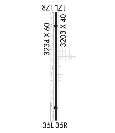
| Rwy | Rwy | |||||||
| 3203x40 | 3203' | 3203x40 | 3203' | |||||
| 3234x60 | 3234' | 3234x60 | 3234' | |||||
| Runway ID | Single Wheel | Double Wheel | Double Tandem Wheel | Dual Double Wheel |
| 18L/36R | 10,000 | N/A | N/A | N/A |
| 18R/36L | N/A | N/A | N/A | N/A |
| These numbers are Advisory and are not limits. The Airport Manager should have more accurate Weight Limits | ||||
 Airport Diagram might not be current. | |
| Facility Name: | MINEOLA WISENER FLD |
| City Name: | MINEOLA |
| County: | WOOD |
| State abbrev: | TX |
| State Name: | TEXAS |
| Ownership: | PRIVATELY OWNED |
| Use: | OPEN TO THE PUBLIC |
| Owner's Name: | R. H. WISENER |
| Address: | P.O. BOX 65 |
| MINEOLA, TX 75773 | |
| Owner's Phone: | 903-569-1929 |
| Manager's Name: | LUPITA A. WISENER; AMGR LIVES ADJ. |
| Address: | 1412 COUNTRY CLUB DRIVE |
| MINEOLA, TX 75773 | |
| Phone: | (903) 569-1929 |
| FAA Region: | SOUTHWEST |
| FAA Field Office: | TEX |
| Date | Sunrise | Sunset |
|---|---|---|
| 09/24/21 Friday | 7:11 | 19:16 |
| 09/25/21 Saturday | 7:12 | 19:15 |
| 09/26/21 Sunday | 7:13 | 19:14 |
| 09/27/21 Monday | 7:13 | 19:12 |
| 09/28/21 Tuesday | 7:14 | 19:11 |
| 09/29/21 Wednesday | 7:15 | 19:10 |
| 09/30/21 Thursday | 7:15 | 19:08 |
| 10/01/21 Friday | 7:16 | 19:07 |
| 10/02/21 Saturday | 7:17 | 19:06 |
| 10/03/21 Sunday | 7:17 | 19:04 |
| 10/04/21 Monday | 7:18 | 19:03 |
| 10/05/21 Tuesday | 7:19 | 19:02 |
| 10/06/21 Wednesday | 7:19 | 19:00 |
| 10/07/21 Thursday | 7:20 | 18:59 |
| Airport Attendance Schedule | CONTINUOUS |
| Airport Status | OPERATIONAL (This Status can change at any time - please check NOTAMS) |
| Airport Lighting Schedule | ACTVT LIRL RWY 18L/36R - CTAF. |
| Airport Storage Available | Tie Downs |
| Extra Services Available | Flight Instruction, Annual Surveying |
| Wind Indicator | YES - (unlit) |
| Control Tower | NO |
| CTAF Frequency | 122.800 |
| Unicom Frequency | 122.800 |
| Rotating Beacon Color | CLEAR-GREEN (Light Land Airport) |
| Segmented Circle | NO |
| Landing Fee | NO |
| Airport Inspected | STATE - performed by PRIVATE CONTRACT PERSONNEL |
| Inspection Date | 03/29/2019 |
| Type of Fuel Available | Grade 100LL; -10FUEL AVBL 24 HR SELF-SERVICE WITH MAJOR CREDIT CARD. |
| Airframe Repair Service | MAJOR |
| Power Plant Repair Service | MAJOR |
| Latitude | N3240.6 |
| Longitude | W09530.7 (ESTIMATED) |
| Arpt Elevation | 430ft (SURVEYED) |
| Magnetic Variation | 02E |
| 1 miles W | of MINEOLA |
| Traffic Pattern Altitude | |
| Sectional Chart | DALLAS-FT WORTH |
| Operations (Reported) | Yearly | Avg. Daily |
|---|---|---|
| General Aviation Transient | 3500 | 10 |
| General Aviation Local | 5000 | 14 |
| Air Taxi | 0 | 0 |
| Commerical | 0 | 0 |
| Commuter | 0 | 0 |
| Military | 0 | 0 |
| Aircraft based on Field | |
|---|---|
| General Aviation Singles | 56 |
| General Aviation Multi | 2 |
| Jet Aircraft | 0 |
| General Aviation Helicopters | 0 |
| Military Aircraft | 0 |
| Gliders | 2 |
| Ultralights | 4 |
| FSS on field | NO |
| FSS tie-in | FORT WORTH |
| FSS Phone | 1-800-WX-BRIEF |
| Who issues Notams | FTW |
| Notam D service at airport | YES |
| ARTCC Name | FORT WORTH |
| Airport Certification | |
| Aircraft Rescue & Firefighting Index | None |
| Airport of Entry | No |
| Custom Landing Rights | No |
| Joint Civil/Military | No |
| Military Landing rights | No |
| FOR CD CTC FORT WORTH ARTCC AT 817-858-7584. |
| RWY 18L/ 36RRWY SFC HAS SOME LOOSE AGGREGATE AND SEVERAL ROUGH PATCHES AT THRS. |
| RWY 18L/ 36RTHLD AT BOTH RY ENDS MARKED BY TWO RED LIGHTS. |
Airport Communications & Frequencies:
| |||||||||||||||||
| Runway: 18L | Runway: 36R | ||
| Mag heading: | 179° | Mag heading: | 359° |
| Rwy Slope: | -.79% Down | Rwy Slope: | .79% Up |
| Approach: | Approach: | ||
| Pattern: | Left Traffic | Pattern: | Left Traffic |
| Markings: | BASIC | Markings: | BASIC |
| Marking Condition: | GOOD | Marking Condition: | GOOD |
| Arresting Dev: | Arresting Dev: | ||
| Lat & Long: | N3240.9 W09530.6 | Lat. & Long.: | N3240.3 W09530.7 |
| Elev: | 429.3 ft. MSL | Elev: | 403.9 ft. MSL |
| TCH: | TCH: | ||
| Visual Glide Path: | Visual Glide Path: | ||
| Displaced Threshold: | RYS 18L & 36R THLDS DSPLCD 140 FT NIGHT ONLY. | Displaced Threshold: | No |
| Touchdown Zone: | YES | Touchdown Zone: | YES |
| Touchdown Elev.: | 429.3 feet | Touchdown Elev.: | 427.6 feet |
| Visual Glide Slope: | Visual Glide Slope: | ||
| RVR Equipment: | RVR Equipment: | ||
| RVV Equipment: | NO | RVV Equipment: | NO |
| Approach Lights: | Approach Lights: | ||
| REIL: | NO | REIL: | NO |
| Centerline Lights: | NO | Centerline Lights: | NO |
| Touchdown lights: | NO | Touchdown lights: | NO |
| Runway Category: | Runway with a Visual Approach | Runway Category: | Runway with a Visual Approach |
| Declared Distances: | Declared Distances: | ||
| Obstructions: | TREES | Obstructions: | TREES |
| Marked: | NOT Marked/Lighted | Marked: | NOT Marked/Lighted |
| Clearance slope: | APCH RATIO 3:1 AT THLD LTS OVR 80 FT TREES, 344 DSTC, 80 FT R. | Clearance slope: | |
| Obstruction height: | 80 feet AGL | Obstruction height: | 80 feet AGL |
| Dist. from runway: | 201 feet | Dist. from runway: | 201 feet |
| Centerline offset: | 65 right of centerline | Centerline offset: | 64 feet right of centerline |
| Comments: | +4 FT FENCE, & 15 FT ROAD AT THLD ACROSS APCH 5 FT DSTC. | Comments: | 15 FT RD; 4 FT FENCE AT THLD. 80 FT TREES 60 FT DSTC 125 FT L. |
| Runway: 18R | Runway: 36L | ||
| Mag heading: | 178° | Mag heading: | 358° |
| Rwy Slope: | .03% Up | Rwy Slope: | -.03% Down |
| Approach: | Approach: | ||
| Pattern: | Left Traffic | Pattern: | Left Traffic |
| Markings: | NONE | Markings: | NONE |
| Marking Condition: | GOOD | Marking Condition: | GOOD |
| Arresting Dev: | Arresting Dev: | ||
| Lat & Long: | N3240.9 W09530.7 | Lat. & Long.: | N3240.3 W09530.7 |
| Elev: | 429.0 ft. MSL | Elev: | 430.0 ft. MSL |
| TCH: | TCH: | ||
| Visual Glide Path: | Visual Glide Path: | ||
| Displaced Threshold: | No | Displaced Threshold: | No |
| Touchdown Zone: | YES | Touchdown Zone: | YES |
| Touchdown Elev.: | 429.0 feet | Touchdown Elev.: | 430.0 feet |
| Visual Glide Slope: | Visual Glide Slope: | ||
| RVR Equipment: | RVR Equipment: | ||
| RVV Equipment: | NO | RVV Equipment: | NO |
| Approach Lights: | Approach Lights: | ||
| REIL: | NO | REIL: | NO |
| Centerline Lights: | NO | Centerline Lights: | NO |
| Touchdown lights: | NO | Touchdown lights: | NO |
| Runway Category: | Runway with a Visual Approach | Runway Category: | Runway with a Visual Approach |
| Declared Distances: | Declared Distances: | ||
| Obstructions: | TREES | Obstructions: | TREES |
| Marked: | NOT Marked/Lighted | Marked: | NOT Marked/Lighted |
| Clearance slope: | Clearance slope: | ||
| Obstruction height: | 80 feet AGL | Obstruction height: | 50 feet AGL |
| Dist. from runway: | 0 feet | Dist. from runway: | 0 feet |
| Centerline offset: | 90 right of centerline | Centerline offset: | 72 |
| Comments: | Comments: |
Thanks for using FltPlan.com
all rights reserved © 1999-2021 by Flight Plan LLC
