
| JONES MEMORIAL BRISTOW OK |
| |
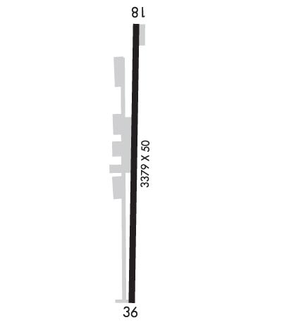
| Lat: N 3548.4 Long: W 09625.3 Elev: 870 Var: -05 Longest Runway: 4001 | ||
| CTAF: 122.9 | ||
| ||||||
|
| Rwy | Rwy | |||||||
| 4001x75 | 4001' | 4001x75 | 4001' | |||||
| Runway ID | Single Wheel | Double Wheel | Double Tandem Wheel | Dual Double Wheel |
| 18/36 | 4,000 | N/A | N/A | N/A |
| These numbers are Advisory and are not limits. The Airport Manager should have more accurate Weight Limits | ||||
 Airport Diagram might not be current. | |
| Facility Name: | JONES MEML |
| City Name: | BRISTOW |
| County: | CREEK |
| State abbrev: | OK |
| State Name: | OKLAHOMA |
| Ownership: | PUBLICLY OWNED |
| Use: | OPEN TO THE PUBLIC |
| Owner's Name: | CITY OF BRISTOW |
| Address: | 110 W 7TH ST |
| BRISTOW, OK 74010 | |
| Owner's Phone: | 918-367-6244 |
| Manager's Name: | VICKI ROTH |
| Address: | 24503 S 385TH WEST AVE |
| BRISTOW, OK 74010 | |
| Phone: | 832-392-9040 |
| FAA Region: | SOUTHWEST |
| FAA Field Office: | AOK |
| Date | Sunrise | Sunset |
|---|---|---|
| 06/08/26 Monday | 6:09 | 20:40 |
| 06/09/26 Tuesday | 6:09 | 20:41 |
| 06/10/26 Wednesday | 6:09 | 20:41 |
| 06/11/26 Thursday | 6:09 | 20:42 |
| 06/12/26 Friday | 6:09 | 20:42 |
| 06/13/26 Saturday | 6:09 | 20:43 |
| 06/14/26 Sunday | 6:09 | 20:43 |
| 06/15/26 Monday | 6:09 | 20:43 |
| 06/16/26 Tuesday | 6:09 | 20:44 |
| 06/17/26 Wednesday | 6:09 | 20:44 |
| 06/18/26 Thursday | 6:09 | 20:44 |
| 06/19/26 Friday | 6:09 | 20:45 |
| 06/20/26 Saturday | 6:10 | 20:45 |
| 06/21/26 Sunday | 6:10 | 20:45 |
| Airport Attendance Schedule | UNATTENDED |
| Airport Status | OPERATIONAL (This Status can change at any time - please check NOTAMS) |
| Airport Lighting Schedule | MIRL RWY 18/36 ON DUSK - DAWN. INCR INTST - CTAF. |
| Airport Storage Available | Tie Downs |
| Extra Services Available | NONE |
| Wind Indicator | YES - (unlit) |
| Control Tower | NO |
| CTAF Frequency | 122.900 |
| Unicom Frequency | |
| Rotating Beacon Color | WG |
| Segmented Circle | NO |
| Landing Fee | NO |
| Airport Inspected | STATE - performed by STATE AERONAUTICAL PERSONNEL |
| Inspection Date | 06/13/2024 |
| Type of Fuel Available | Grade 100LL, JET A; -1024 HR. AUTOMATED FUEL SERVICE SYSTEM. |
| Airframe Repair Service | None |
| Power Plant Repair Service | None |
| Latitude | N3548.4 |
| Longitude | W09625.3 (ESTIMATED) |
| Arpt Elevation | 869ft (SURVEYED) |
| Magnetic Variation | 05E |
| 3 miles SW | of BRISTOW |
| Traffic Pattern Altitude | |
| Sectional Chart | DALLAS-FT WORTH |
| Operations (Reported) | Yearly | Avg. Daily |
|---|---|---|
| General Aviation Transient | 0 | 0 |
| General Aviation Local | 0 | 0 |
| Air Taxi | 0 | 0 |
| Commerical | 0 | 0 |
| Commuter | 0 | 0 |
| Military | 0 | 0 |
| Aircraft based on Field | |
|---|---|
| General Aviation Singles | 0 |
| General Aviation Multi | 0 |
| Jet Aircraft | 0 |
| General Aviation Helicopters | 0 |
| Military Aircraft | 0 |
| Gliders | 0 |
| Ultralights | 0 |
| FSS on field | NO |
| FSS tie-in | MC ALESTER |
| FSS Phone | 1-800-WX-BRIEF |
| Who issues Notams | MLC |
| Notam D service at airport | YES |
| ARTCC Name | KANSAS CITY |
| Airport Certification | |
| Aircraft Rescue & Firefighting Index | None |
| Airport of Entry | No |
| Custom Landing Rights | No |
| Joint Civil/Military | No |
| Military Landing rights | No |
| NATIONAL PLAN OF INTEGRATED AIRPORT SYSTEMS (NPIAS) |
| FOR CD CTC KANSAS CITY ARTCC AT 913-254-8508. |
Airport Communications & Frequencies:
| |||||||
| Runway: 18 | Runway: 36 | ||
| Mag heading: | 176° | Mag heading: | 356° |
| Rwy Slope: | 1.59% Up | Rwy Slope: | -1.59% Down |
| Approach: | Approach: | ||
| Pattern: | Left Traffic | Pattern: | Left Traffic |
| Markings: | PRECISION INSTRUMENT | Markings: | PRECISION INSTRUMENT |
| Marking Condition: | GOOD | Marking Condition: | GOOD |
| Arresting Dev: | Arresting Dev: | ||
| Lat & Long: | N3548.8 W09625.3 | Lat. & Long.: | N3548.1 W09625.3 |
| Elev: | 806.0 ft. MSL | Elev: | 869.6 ft. MSL |
| TCH: | TCH: | ||
| Visual Glide Path: | Visual Glide Path: | ||
| Displaced Threshold: | No | Displaced Threshold: | No |
| Touchdown Zone: | YES | Touchdown Zone: | YES |
| Touchdown Elev.: | 853.9 feet | Touchdown Elev.: | 869.6 feet |
| Visual Glide Slope: | Visual Glide Slope: | ||
| RVR Equipment: | RVR Equipment: | ||
| RVV Equipment: | NO | RVV Equipment: | NO |
| Approach Lights: | Approach Lights: | ||
| REIL: | NO | REIL: | NO |
| Centerline Lights: | NO | Centerline Lights: | NO |
| Touchdown lights: | NO | Touchdown lights: | NO |
| Runway Category: | Runway with a Non-precision Approach having visibility minimums greater than 3/4 mile | Runway Category: | Runway with a Non-precision Approach having visibility minimums greater than 3/4 mile |
| Declared Distances: | Declared Distances: | ||
| Obstructions: | Obstructions: | TREE | |
| Marked: | Marked: | MARKED | |
| Clearance slope: | 34:1 | Clearance slope: | 23:1 |
| Obstruction height: | Obstruction height: | 26 feet AGL | |
| Dist. from runway: | Dist. from runway: | 800 feet | |
| Centerline offset: | Centerline offset: | 230 feet right of centerline | |
| Comments: | Comments: |
Thanks for using FltPlan.com
all rights reserved © 1999-2026 by Flight Plan LLC
