
| EPHRAIM-FISH CREEK EPHRAIM WI |
| |
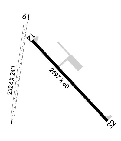
| Lat: N 4508.1 Long: W 08711.3 Elev: 763 Var: +04 Longest Runway: 2697 | ||
| AWOS: 124.17 CTAF: 123.0 | ||
| ||||||||||||||||||||||||||||||||||||||||||||
| ||||||||||||||||||||||||||||||||||||||||||||
| ||||||||||||||||||||||||||||||||||||||||||||
| Rwy | Rwy | |||||||
| 2324x100 | 2324' | 2324x100 | 2324' | |||||
| 2697x60 | 2697' | 2697x60 | 2697' | |||||
| Runway ID | Single Wheel | Double Wheel | Double Tandem Wheel | Dual Double Wheel |
| 01/19 | N/A | N/A | N/A | N/A |
| 14/32 | 12,500 | N/A | N/A | N/A |
| These numbers are Advisory and are not limits. The Airport Manager should have more accurate Weight Limits | ||||
 Airport Diagram might not be current. | |
| Facility Name: | EPHRAIM-GIBRALTAR |
| City Name: | EPHRAIM |
| County: | DOOR |
| State abbrev: | WI |
| State Name: | WISCONSIN |
| Ownership: | PUBLICLY OWNED |
| Use: | OPEN TO THE PUBLIC |
| Owner's Name: | VILLAGE OF EPHRAIM; & TOWN OF GIBRALTAR, BETH HAGEN TOWN CLERK. |
| Address: | PO BOX 850 |
| FISH CREEK, WI 54212 | |
| Owner's Phone: | 920-868-1714 |
| Manager's Name: | BETH HAGEN |
| Address: | P O BOX 850 |
| FISH CREEK, WI 54212 | |
| Phone: | 920-868-1714 |
| FAA Region: | GREAT LAKES |
| FAA Field Office: | CHI |
| Date | Sunrise | Sunset |
|---|---|---|
| 09/24/21 Friday | 6:38 | 18:43 |
| 09/25/21 Saturday | 6:39 | 18:41 |
| 09/26/21 Sunday | 6:40 | 18:39 |
| 09/27/21 Monday | 6:42 | 18:37 |
| 09/28/21 Tuesday | 6:43 | 18:35 |
| 09/29/21 Wednesday | 6:44 | 18:33 |
| 09/30/21 Thursday | 6:45 | 18:31 |
| 10/01/21 Friday | 6:47 | 18:30 |
| 10/02/21 Saturday | 6:48 | 18:28 |
| 10/03/21 Sunday | 6:49 | 18:26 |
| 10/04/21 Monday | 6:50 | 18:24 |
| 10/05/21 Tuesday | 6:52 | 18:22 |
| 10/06/21 Wednesday | 6:53 | 18:20 |
| 10/07/21 Thursday | 6:54 | 18:18 |
| Airport Attendance Schedule | JUN-OCT FRI 1500-1800, JUN-OCT SAT-SUN 1000-1700 |
| Airport Status | OPERATIONAL (This Status can change at any time - please check NOTAMS) |
| Airport Lighting Schedule | ACTVT PAPI RWY 14 & 32; MIRL RWY 14/32 - CTAF. |
| Airport Storage Available | Tie Downs |
| Extra Services Available | NONE |
| Wind Indicator | YES - (lighted) |
| Control Tower | NO |
| CTAF Frequency | 123.000 |
| Unicom Frequency | 123.000 |
| Rotating Beacon Color | CLEAR-GREEN (Light Land Airport) |
| Segmented Circle | YES |
| Landing Fee | NO |
| Airport Inspected | STATE - performed by STATE AERONAUTICAL PERSONNEL |
| Inspection Date | 06/25/2020 |
| Type of Fuel Available | Grade 100LL; -1024 SELF SVC FUEL AVBL. |
| Airframe Repair Service | NONE |
| Power Plant Repair Service | NONE |
| Latitude | N4508.1 |
| Longitude | W08711.3 (ESTIMATED) |
| Arpt Elevation | 763ft (SURVEYED) |
| Magnetic Variation | 04W |
| 1 miles SW | of EPHRAIM |
| Traffic Pattern Altitude | |
| Sectional Chart | GREEN BAY |
| Operations (Reported) | Yearly | Avg. Daily |
|---|---|---|
| General Aviation Transient | 5500 | 15 |
| General Aviation Local | 3500 | 10 |
| Air Taxi | 300 | 1 |
| Commerical | 0 | 0 |
| Commuter | 0 | 0 |
| Military | 0 | 0 |
| Aircraft based on Field | |
|---|---|
| General Aviation Singles | 16 |
| General Aviation Multi | 1 |
| Jet Aircraft | 0 |
| General Aviation Helicopters | 1 |
| Military Aircraft | 0 |
| Gliders | 0 |
| Ultralights | 0 |
| FSS on field | NO |
| FSS tie-in | GREEN BAY |
| FSS Phone | 1-800-WX-BRIEF |
| Who issues Notams | GRB |
| Notam D service at airport | YES |
| ARTCC Name | MINNEAPOLIS |
| Airport Certification | |
| Aircraft Rescue & Firefighting Index | None |
| Airport of Entry | No |
| Custom Landing Rights | No |
| Joint Civil/Military | No |
| Military Landing rights | YES |
| NATIONAL PLAN OF INTEGRATED AIRPORT SYSTEMS (NPIAS) |
| ASSURANCES PURSUANT TO TITLE VI, CIVIL RIGHTS ACT OF 1964 |
| GRANT AGREEMENT HAS EXPIRED; HOWEVER, AGREEMENT REMAINS IN EFFECT FOR THIS FACILITY AS LONG AS IT IS PUBLIC USE. |
| DEER NR MOVEMENT AREAS. |
| FOR CD CTC GREEN BAY APCH AT 920-431-5741, WHEN GREEN BAY APCH CLSD, FOR CD CTC MINNEAPOLIS ARTCC AT 651-463-5588. |
| RWY 01/1 9 SLOPES MDTELY DOWN TO SOUTH--CANNOT SEE ONE END FM THE OTHER. |
Airport Communications & Frequencies:
| |||||||||||||||||
| Runway: 01 | Runway: 19 | ||
| Mag heading: | 12° | Mag heading: | 192° |
| Rwy Slope: | .34% Up | Rwy Slope: | -.34% Down |
| Approach: | Approach: | ||
| Pattern: | Left Traffic | Pattern: | Left Traffic |
| Markings: | NONE | Markings: | NONE |
| Marking Condition: | RY 01 /19 ENDS & EDGES MKD WITH YELLOW CONES. | Marking Condition: | |
| Arresting Dev: | Arresting Dev: | ||
| Lat & Long: | N4508.0 W08711.5 | Lat. & Long.: | N4508.4 W08711.4 |
| Elev: | 754.9 ft. MSL | Elev: | 762.9 ft. MSL |
| TCH: | TCH: | ||
| Visual Glide Path: | Visual Glide Path: | ||
| Displaced Threshold: | No | Displaced Threshold: | No |
| Touchdown Zone: | YES | Touchdown Zone: | YES |
| Touchdown Elev.: | 762.9 feet | Touchdown Elev.: | 762.9 feet |
| Visual Glide Slope: | Visual Glide Slope: | ||
| RVR Equipment: | RVR Equipment: | ||
| RVV Equipment: | NO | RVV Equipment: | NO |
| Approach Lights: | Approach Lights: | ||
| REIL: | NO | REIL: | NO |
| Centerline Lights: | NO | Centerline Lights: | NO |
| Touchdown lights: | NO | Touchdown lights: | NO |
| Runway Category: | Runway with a Visual Approach | Runway Category: | Runway with a Visual Approach |
| Declared Distances: | Declared Distances: | ||
| Obstructions: | TREE | Obstructions: | |
| Marked: | NOT Marked/Lighted | Marked: | |
| Clearance slope: | 10:1 | Clearance slope: | 20:1 |
| Obstruction height: | 16 feet AGL | Obstruction height: | |
| Dist. from runway: | 160 feet | Dist. from runway: | |
| Centerline offset: | 100 right of centerline | Centerline offset: | |
| Comments: | Comments: |
| Runway: 14 | Runway: 32 | ||
| Mag heading: | 140° | Mag heading: | 320° |
| Rwy Slope: | -.46% Down | Rwy Slope: | .46% Up |
| Approach: | Approach: | ||
| Pattern: | Left Traffic | Pattern: | Left Traffic |
| Markings: | NONPRECISION INSTRUMENT | Markings: | NONPRECISION INSTRUMENT |
| Marking Condition: | GOOD | Marking Condition: | GOOD |
| Arresting Dev: | Arresting Dev: | ||
| Lat & Long: | N4508.3 W08711.4 | Lat. & Long.: | N4508.0 W08710.9 |
| Elev: | 763.2 ft. MSL | Elev: | 750.9 ft. MSL |
| TCH: | 24 ft. AGL | TCH: | 25 ft. AGL |
| Visual Glide Path: | 3.50 degrees | Visual Glide Path: | 3.00 degrees |
| Displaced Threshold: | No | Displaced Threshold: | No |
| Touchdown Zone: | YES | Touchdown Zone: | YES |
| Touchdown Elev.: | 763.2 feet | Touchdown Elev.: | 763.2 feet |
| Visual Glide Slope: | 2-Light PAPI on LEFT side of Runway | Visual Glide Slope: | 2-Light PAPI on LEFT side of Runway |
| RVR Equipment: | RVR Equipment: | ||
| RVV Equipment: | NO | RVV Equipment: | NO |
| Approach Lights: | Approach Lights: | ||
| REIL: | NO | REIL: | NO |
| Centerline Lights: | NO | Centerline Lights: | NO |
| Touchdown lights: | NO | Touchdown lights: | NO |
| Runway Category: | Runway with a Non-precision Approach | Runway Category: | Runway with a Non-precision Approach |
| Declared Distances: | Declared Distances: |
Thanks for using FltPlan.com
all rights reserved © 1999-2021 by Flight Plan LLC