
| CABLE UNION CABLE WI |
| |
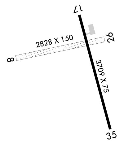
| Lat: N 4611.7 Long: W 09114.9 Elev: 1360 Var: +02 Longest Runway: 3709 | ||
| CTAF: 122.8 | ||
| ||||||||||||||||||||||||||||||||||||||||||||
| ||||||||||||||||||||||||||||||||||||||||||||
| Rwy | Rwy | |||||||
| 2194x150 | 1816' | 2194x150 | 2194' | |||||
| 3709x75 | 3518' | 3709x75 | 3146' | |||||
| Runway ID | Single Wheel | Double Wheel | Double Tandem Wheel | Dual Double Wheel |
| 08/26 | N/A | N/A | N/A | N/A |
| 17/35 | 28,000 | N/A | N/A | N/A |
| These numbers are Advisory and are not limits. The Airport Manager should have more accurate Weight Limits | ||||
 Airport Diagram might not be current. | |
| Facility Name: | CABLE UNION |
| City Name: | CABLE |
| County: | BAYFIELD |
| State abbrev: | WI |
| State Name: | WISCONSIN |
| Ownership: | PUBLICLY OWNED |
| Use: | OPEN TO THE PUBLIC |
| Owner's Name: | TOWN OF CABLE; AND TOWN OF DRUMMOND & NAMEGAGON. |
| Address: | PO BOX 476 |
| CABLE, WI 54821 | |
| Owner's Phone: | 715-798-4440 |
| Manager's Name: | MIKE NICHOLS |
| Address: | 42905 TELEMARK RD, PO BOX 248 |
| CABLE, WI 54821 | |
| Phone: | 715-798-3240 |
| FAA Region: | GREAT LAKES |
| FAA Field Office: | CHI |
| Date | Sunrise | Sunset |
|---|---|---|
| 06/12/26 Friday | 5:13 | 20:57 |
| 06/13/26 Saturday | 5:13 | 20:57 |
| 06/14/26 Sunday | 5:13 | 20:58 |
| 06/15/26 Monday | 5:13 | 20:58 |
| 06/16/26 Tuesday | 5:13 | 20:59 |
| 06/17/26 Wednesday | 5:13 | 20:59 |
| 06/18/26 Thursday | 5:13 | 20:59 |
| 06/19/26 Friday | 5:13 | 21:00 |
| 06/20/26 Saturday | 5:13 | 21:00 |
| 06/21/26 Sunday | 5:13 | 21:00 |
| 06/22/26 Monday | 5:13 | 21:00 |
| 06/23/26 Tuesday | 5:14 | 21:01 |
| 06/24/26 Wednesday | 5:14 | 21:01 |
| 06/25/26 Thursday | 5:14 | 21:01 |
| Airport Attendance Schedule | UNATTENDED |
| Airport Status | OPERATIONAL (This Status can change at any time - please check NOTAMS) |
| Airport Lighting Schedule | MIRL RWY 17/35 PRESET TO LOW SS-SR; TO INCR INTST AND ACTVT - CTAF. |
| Airport Storage Available | Tie Downs |
| Extra Services Available | NONE |
| Wind Indicator | YES - (lighted) |
| Control Tower | NO |
| CTAF Frequency | 122.800 |
| Unicom Frequency | 122.800 |
| Rotating Beacon Color | WG |
| Segmented Circle | NO |
| Landing Fee | NO |
| Airport Inspected | STATE - performed by STATE AERONAUTICAL PERSONNEL |
| Inspection Date | 06/20/2024 |
| Type of Fuel Available | Grade 100LL; -1024 HR SELF SVC FUEL AVBL WITH CREDIT CARD. |
| Airframe Repair Service | NONE |
| Power Plant Repair Service | NONE |
| Latitude | N4611.7 |
| Longitude | W09114.9 (ESTIMATED) |
| Arpt Elevation | 1360ft (SURVEYED) |
| Magnetic Variation | 02W |
| 2 miles SE | of CABLE |
| Traffic Pattern Altitude | |
| Sectional Chart | GREEN BAY |
| Operations (Reported) | Yearly | Avg. Daily |
|---|---|---|
| General Aviation Transient | 0 | 0 |
| General Aviation Local | 0 | 0 |
| Air Taxi | 0 | 0 |
| Commerical | 0 | 0 |
| Commuter | 0 | 0 |
| Military | 0 | 0 |
| Aircraft based on Field | |
|---|---|
| General Aviation Singles | 0 |
| General Aviation Multi | 0 |
| Jet Aircraft | 0 |
| General Aviation Helicopters | 0 |
| Military Aircraft | 0 |
| Gliders | 0 |
| Ultralights | 0 |
| FSS on field | NO |
| FSS tie-in | GREEN BAY |
| FSS Phone | 1-800-WX-BRIEF |
| Who issues Notams | GRB |
| Notam D service at airport | YES |
| ARTCC Name | MINNEAPOLIS |
| Airport Certification | |
| Aircraft Rescue & Firefighting Index | None |
| Airport of Entry | No |
| Custom Landing Rights | No |
| Joint Civil/Military | No |
| Military Landing rights | YES |
| NATIONAL PLAN OF INTEGRATED AIRPORT SYSTEMS (NPIAS) |
| GRANT AGREEMENTS UNDER FAAP/ADAP/AIP |
| ASSURANCES PURSUANT TO TITLE VI, CIVIL RIGHTS ACT OF 1964 |
| RY 08/26 CLSD NOV 21 - MAY 1. |
| TWY LGTS AT ENTRANCE TO TWY ONLY. |
| PLUG IN AVBL. NO HEATING UNITS AVBL TO START ACFT. |
| RY CONDITIONS NOT REPORTED. |
| FOR CD CTC MINNEAPOLIS ARTCC AT 651-463-5588. |
| FQT WILDLIFE ON & INVOF ARPT. |
Airport Communications & Frequencies:
| |||||||||
| Runway: 08 | Runway: 26 | ||
| Mag heading: | 80° | Mag heading: | 260° |
| Rwy Slope: | .00% | Rwy Slope: | .00% |
| Approach: | Approach: | ||
| Pattern: | Left Traffic | Pattern: | Left Traffic |
| Markings: | NONE | Markings: | NONE |
| Marking Condition: | FAIR; RWY 08/26 MKD WITH YELLOW CONES. | Marking Condition: | FAIR |
| Arresting Dev: | Arresting Dev: | ||
| Lat & Long: | N4611.7 W09115.4 | Lat. & Long.: | N4611.8 W09114.9 |
| Elev: | 1344.0 ft. MSL | Elev: | 1344.0 ft. MSL |
| TCH: | TCH: | ||
| Visual Glide Path: | Visual Glide Path: | ||
| Displaced Threshold: | 378 feet | Displaced Threshold: | No |
| Touchdown Zone: | YES | Touchdown Zone: | YES |
| Touchdown Elev.: | 1344.0 feet | Touchdown Elev.: | 1344.0 feet |
| Visual Glide Slope: | Visual Glide Slope: | ||
| RVR Equipment: | RVR Equipment: | ||
| RVV Equipment: | NO | RVV Equipment: | NO |
| Approach Lights: | Approach Lights: | ||
| REIL: | NO | REIL: | NO |
| Centerline Lights: | NO | Centerline Lights: | NO |
| Touchdown lights: | NO | Touchdown lights: | NO |
| Runway Category: | Runway with a Visual Approach | Runway Category: | Runway with a Visual Approach |
| Declared Distances: | Declared Distances: | ||
| Obstructions: | TREES | Obstructions: | |
| Marked: | NOT Marked/Lighted | Marked: | |
| Clearance slope: | 12:1; APCH RATIO 20:1 TO DSPLCD THR. | Clearance slope: | 20:1 |
| Obstruction height: | 47 feet AGL | Obstruction height: | |
| Dist. from runway: | 610 feet | Dist. from runway: | |
| Centerline offset: | 50 right of centerline | Centerline offset: | |
| Comments: | Comments: |
| Runway: 17 | Runway: 35 | ||
| Mag heading: | 167° | Mag heading: | 347° |
| Rwy Slope: | .35% Up | Rwy Slope: | -.35% Down |
| Approach: | Approach: | ||
| Pattern: | Left Traffic | Pattern: | Left Traffic |
| Markings: | NONPRECISION INSTRUMENT | Markings: | NONPRECISION INSTRUMENT |
| Marking Condition: | GOOD | Marking Condition: | GOOD |
| Arresting Dev: | Arresting Dev: | ||
| Lat & Long: | N4611.9 W09114.9 | Lat. & Long.: | N4611.4 W09114.7 |
| Elev: | 1347.1 ft. MSL | Elev: | 1360.2 ft. MSL |
| TCH: | TCH: | ||
| Visual Glide Path: | Visual Glide Path: | ||
| Displaced Threshold: | 191 feet | Displaced Threshold: | 563 feet |
| Touchdown Zone: | YES | Touchdown Zone: | YES |
| Touchdown Elev.: | 1357.7 feet | Touchdown Elev.: | 1357.2 feet |
| Visual Glide Slope: | Visual Glide Slope: | ||
| RVR Equipment: | RVR Equipment: | ||
| RVV Equipment: | NO | RVV Equipment: | NO |
| Approach Lights: | Approach Lights: | ||
| REIL: | NO | REIL: | NO |
| Centerline Lights: | NO | Centerline Lights: | NO |
| Touchdown lights: | NO | Touchdown lights: | NO |
| Runway Category: | Runway with a Visual Approach | Runway Category: | Runway with a Non-precision Approach |
| Declared Distances: | TORA:3709' TODA:3709' ASDA:3709' LDA:3519' | Declared Distances: | TORA:3709' TODA:3709' ASDA:3709' LDA:3146' |
| Obstructions: | TREES | Obstructions: | TREES |
| Marked: | NOT Marked/Lighted | Marked: | NOT Marked/Lighted |
| Clearance slope: | 1:1; APCH RATIO 12:1 TO DSPLCD THR; 40 FT TREES 431 FT FM DSPCLD THR, 220 FT R. | Clearance slope: | 7:1; APCH RATIO 20:1 TO DSPLCD THR. |
| Obstruction height: | 40 feet AGL | Obstruction height: | 60 feet AGL |
| Dist. from runway: | 240 feet | Dist. from runway: | 670 feet |
| Centerline offset: | 220 right of centerline | Centerline offset: | 270 feet left of centerline |
| Comments: | Comments: |
Thanks for using FltPlan.com
all rights reserved © 1999-2026 by Flight Plan LLC
