
| LITTLEBROOK AIR PARK ELIOT ME |
| |
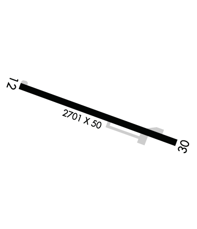
| Lat: N 4308.6 Long: W 07046.4 Elev: 125 Var: +16 Longest Runway: 2701 | ||
| CTAF: 122.9 | ||
| ||
| Rwy | Rwy | |||||||
| 2701x50 | 2701' | 2701x50 | 2615' | |||||
| Runway ID | Single Wheel | Double Wheel | Double Tandem Wheel | Dual Double Wheel |
| 12/30 | 8,000 | N/A | N/A | N/A |
| These numbers are Advisory and are not limits. The Airport Manager should have more accurate Weight Limits | ||||
 Airport Diagram might not be current. | |
| Facility Name: | SEACOAST AIRFIELD |
| City Name: | ELIOT |
| County: | YORK |
| State abbrev: | ME |
| State Name: | MAINE |
| Ownership: | PRIVATELY OWNED |
| Use: | OPEN TO THE PUBLIC |
| Owner's Name: | SHAMROCK AVIATION |
| Address: | 380 LAFAYETTE RD, UNIT 11-209 |
| SEABROOK, NH 03874 | |
| Owner's Phone: | 207-200-5019 |
| Manager's Name: | THOMAS SHAUGHNESSY |
| Address: | 380 LAFAYETTE RD, SUITE 11-209 |
| SEABROOK, NH 03874 | |
| Phone: | 949-378-8405 |
| FAA Region: | NEW ENGLAND |
| FAA Field Office: | NONE |
| Date | Sunrise | Sunset |
|---|---|---|
| 06/08/26 Monday | 5:04 | 20:21 |
| 06/09/26 Tuesday | 5:03 | 20:21 |
| 06/10/26 Wednesday | 5:03 | 20:22 |
| 06/11/26 Thursday | 5:03 | 20:23 |
| 06/12/26 Friday | 5:03 | 20:23 |
| 06/13/26 Saturday | 5:03 | 20:24 |
| 06/14/26 Sunday | 5:03 | 20:24 |
| 06/15/26 Monday | 5:03 | 20:24 |
| 06/16/26 Tuesday | 5:03 | 20:25 |
| 06/17/26 Wednesday | 5:03 | 20:25 |
| 06/18/26 Thursday | 5:03 | 20:25 |
| 06/19/26 Friday | 5:03 | 20:26 |
| 06/20/26 Saturday | 5:03 | 20:26 |
| 06/21/26 Sunday | 5:03 | 20:26 |
| Airport Attendance Schedule | UNATTENDED |
| Airport Status | CLOSED INDEFINITELY (This Status can change at any time - please check NOTAMS) |
| Airport Lighting Schedule | |
| Airport Storage Available | Tie Downs |
| Extra Services Available | NONE |
| Wind Indicator | YES - (unlit) |
| Control Tower | NO |
| CTAF Frequency | 122.900 |
| Unicom Frequency | |
| Rotating Beacon Color | |
| Segmented Circle | NO |
| Landing Fee |
| Airport Inspected | STATE - performed by PRIVATE CONTRACT PERSONNEL |
| Inspection Date | 08/14/2023 |
| Type of Fuel Available | None |
| Airframe Repair Service | NONE |
| Power Plant Repair Service | NONE |
| Latitude | N4308.6 |
| Longitude | W07046.4 (ESTIMATED) |
| Arpt Elevation | 124ft (ESTIMATED) |
| Magnetic Variation | 16W |
| 2 miles SE | of ELIOT |
| Traffic Pattern Altitude | |
| Sectional Chart | NEW YORK |
| Operations (Reported) | Yearly | Avg. Daily |
|---|---|---|
| General Aviation Transient | 0 | 0 |
| General Aviation Local | 0 | 0 |
| Air Taxi | 0 | 0 |
| Commerical | 0 | 0 |
| Commuter | 0 | 0 |
| Military | 0 | 0 |
| Aircraft based on Field | |
|---|---|
| General Aviation Singles | 0 |
| General Aviation Multi | 0 |
| Jet Aircraft | 0 |
| General Aviation Helicopters | 0 |
| Military Aircraft | 0 |
| Gliders | 0 |
| Ultralights | 0 |
| FSS on field | NO |
| FSS tie-in | BANGOR |
| FSS Phone | 1-800-WX-BRIEF |
| Who issues Notams | BGR |
| Notam D service at airport | YES |
| ARTCC Name | BOSTON |
| Airport Certification | |
| Aircraft Rescue & Firefighting Index | None |
| Airport of Entry | No |
| Custom Landing Rights | No |
| Joint Civil/Military | No |
| Military Landing rights | No |
| BIRDS & DEER ON & INVOF ARPT. |
| FOR CD CTC BOSTON APCH AT 603-594-5551. |
| (ARPT STATUS) ARPT CLSD INDEFLY. |
Airport Communications & Frequencies:
| ||||||||||||
| Runway: 12 | Runway: 30 | ||
| Mag heading: | 126° | Mag heading: | 306° |
| Rwy Slope: | -.66% Down | Rwy Slope: | .66% Up |
| Approach: | Approach: | ||
| Pattern: | Left Traffic | Pattern: | Left Traffic |
| Markings: | NONPRECISION INSTRUMENT | Markings: | NONPRECISION INSTRUMENT |
| Marking Condition: | GOOD | Marking Condition: | GOOD |
| Arresting Dev: | Arresting Dev: | ||
| Lat & Long: | N4308.7 W07046.7 | Lat. & Long.: | N4308.5 W07046.1 |
| Elev: | 123.6 ft. MSL | Elev: | 105.7 ft. MSL |
| TCH: | TCH: | ||
| Visual Glide Path: | Visual Glide Path: | ||
| Displaced Threshold: | No | Displaced Threshold: | 86 feet |
| Touchdown Zone: | YES | Touchdown Zone: | YES |
| Touchdown Elev.: | 124.8 feet | Touchdown Elev.: | 124.8 feet |
| Visual Glide Slope: | Visual Glide Slope: | ||
| RVR Equipment: | RVR Equipment: | ||
| RVV Equipment: | NO | RVV Equipment: | NO |
| Approach Lights: | Approach Lights: | ||
| REIL: | NO | REIL: | NO |
| Centerline Lights: | NO | Centerline Lights: | NO |
| Touchdown lights: | NO | Touchdown lights: | NO |
| Runway Category: | Runway with a Visual Approach | Runway Category: | Runway with a Non-precision Approach |
| Declared Distances: | Declared Distances: | ||
| Obstructions: | TREES | Obstructions: | TREES |
| Marked: | NOT Marked/Lighted | Marked: | NOT Marked/Lighted |
| Clearance slope: | Clearance slope: | 5:1; 30 FT TREE 5 FT FM DTHR, 180 FT L; 0:1 SLP TO DTHR. | |
| Obstruction height: | 25 feet AGL | Obstruction height: | 30 feet AGL |
| Dist. from runway: | 201 feet | Dist. from runway: | 360 feet |
| Centerline offset: | 60 left of centerline | Centerline offset: | 130 feet right of centerline |
| Comments: | 20-25 FT TREES AND BRUSH 0-200 FT FM THR, 115-125 FT L OF CNTRLN; 5-25 FT TREES 5-150 FT FM THR, 15-150 FT R OF CNTRLN AND 15-250 FT L OF CNTRLN. | Comments: | 20 FT TREES 90-135 FT FM THR, 90 FT R OF CNTRLN; 23 FT HOUSE 68 FT FM THR, 118 FT L OF CNTRLN; 35 FT TREES 90 FT FM THR, 100 FT L OF CNTRLN. |
Thanks for using FltPlan.com
all rights reserved © 1999-2026 by Flight Plan LLC
