
| SOUTHEAST GREENSBORO GREENSBORO NC |
| |
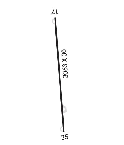
| Lat: N 3556.5 Long: W 07941.1 Elev: 739 Var: +06 Longest Runway: 3064 | ||
| CTAF: 122.8 | ||
| ||||||||||||||||||||||||||||||||
| ||||||||||||||||||||||||||||||||
| Rwy | Rwy | |||||||
| 3064x30 | 3064' | 3064x30 | 3064' | |||||
| Runway ID | Single Wheel | Double Wheel | Double Tandem Wheel | Dual Double Wheel |
| 17/35 | 8,000 | N/A | N/A | N/A |
| These numbers are Advisory and are not limits. The Airport Manager should have more accurate Weight Limits | ||||
| FltPlan does not have IFR approach charts available for K3A4. |
 Airport Diagram might not be current. | |
| Facility Name: | GREENSBORO EXEC |
| City Name: | GREENSBORO |
| County: | GUILFORD |
| State abbrev: | NC |
| State Name: | NORTH CAROLINA |
| Ownership: | PRIVATELY OWNED |
| Use: | OPEN TO THE PUBLIC |
| Owner's Name: | 3A4, LLC |
| Address: | 4505 SELLERS AVE |
| GREENSBORO, NC 27407-0007 | |
| Owner's Phone: | 336-420-8623 |
| Manager's Name: | ANTHONY VOGT |
| Address: | 6334 MONNETT ROAD |
| CLIMAX, NC 27233-8088 | |
| Phone: | 336-420-8623 |
| FAA Region: | SOUTHERN |
| FAA Field Office: | MEM |
| Date | Sunrise | Sunset |
|---|---|---|
| 06/08/26 Monday | 6:02 | 20:34 |
| 06/09/26 Tuesday | 6:02 | 20:34 |
| 06/10/26 Wednesday | 6:02 | 20:35 |
| 06/11/26 Thursday | 6:02 | 20:35 |
| 06/12/26 Friday | 6:02 | 20:36 |
| 06/13/26 Saturday | 6:02 | 20:36 |
| 06/14/26 Sunday | 6:02 | 20:36 |
| 06/15/26 Monday | 6:02 | 20:37 |
| 06/16/26 Tuesday | 6:02 | 20:37 |
| 06/17/26 Wednesday | 6:02 | 20:38 |
| 06/18/26 Thursday | 6:02 | 20:38 |
| 06/19/26 Friday | 6:02 | 20:38 |
| 06/20/26 Saturday | 6:02 | 20:38 |
| 06/21/26 Sunday | 6:02 | 20:39 |
| Airport Attendance Schedule | 7 Days A Week 0700 TO 1700 |
| Airport Status | OPERATIONAL (This Status can change at any time - please check NOTAMS) |
| Airport Lighting Schedule | ACTVT MIRL RWY 17/35, 5 CLICKS ONLY - CTAF MORE THAN 5 LOCK OUT CTL FOR 10 MIN. |
| Airport Storage Available | Tie Downs, Hanger |
| Extra Services Available | Flight Instruction, Aircraft Rental |
| Wind Indicator | YES - (lighted) |
| Control Tower | NO |
| CTAF Frequency | 122.800 |
| Unicom Frequency | 122.800 |
| Rotating Beacon Color | |
| Segmented Circle | NO |
| Landing Fee | NO |
| Airport Inspected | STATE - performed by STATE AERONAUTICAL PERSONNEL |
| Inspection Date | 07/12/2025 |
| Type of Fuel Available | None |
| Airframe Repair Service | MAJOR |
| Power Plant Repair Service | MAJOR |
| Latitude | N3556.5 |
| Longitude | W07941.1 (ESTIMATED) |
| Arpt Elevation | 739ft (ESTIMATED) |
| Magnetic Variation | 06W |
| 8 miles SE | of GREENSBORO |
| Traffic Pattern Altitude | |
| Sectional Chart | CHARLOTTE |
| Operations (Reported) | Yearly | Avg. Daily |
|---|---|---|
| General Aviation Transient | 0 | 0 |
| General Aviation Local | 0 | 0 |
| Air Taxi | 0 | 0 |
| Commerical | 0 | 0 |
| Commuter | 0 | 0 |
| Military | 0 | 0 |
| Aircraft based on Field | |
|---|---|
| General Aviation Singles | 0 |
| General Aviation Multi | 0 |
| Jet Aircraft | 0 |
| General Aviation Helicopters | 0 |
| Military Aircraft | 0 |
| Gliders | 0 |
| Ultralights | 0 |
| FSS on field | NO |
| FSS tie-in | RALEIGH |
| FSS Phone | 1-800-WX-BRIEF |
| Who issues Notams | RDU |
| Notam D service at airport | YES |
| ARTCC Name | WASHINGTON |
| Airport Certification | |
| Aircraft Rescue & Firefighting Index | None |
| Airport of Entry | No |
| Custom Landing Rights | No |
| Joint Civil/Military | No |
| Military Landing rights | No |
| RWY 17 UPHILL LNDG PREF. |
| RWY 17 HAS 50 FT DROP-OFF 60 FT FROM RWY END OFFSET 30 FT BOTH SIDES OF CNTRLN. |
| FOR CD CTC GREENSBORO APCH AT 743-222-6129. |
| RWY 17/35 TURN-AROUNDS ARE PART OF THE RWY THERE IS NO RUNUP AREA AT EITHER END. |
| RWY 17/3 5 ONLY TWO END LGTS EACH SIDE. |
| Runway: 17 | Runway: 35 | ||
| Mag heading: | 170° | Mag heading: | 350° |
| Rwy Slope: | 2.19% Up | Rwy Slope: | -2.19% Down |
| Approach: | Approach: | ||
| Pattern: | Left Traffic | Pattern: | Left Traffic |
| Markings: | NONSTANDARD | Markings: | NONSTANDARD |
| Marking Condition: | FAIR; RWY NRS SMALLER THAN STD. | Marking Condition: | FAIR; RWY NRS SMALLER THAN STD. |
| Arresting Dev: | Arresting Dev: | ||
| Lat & Long: | N3556.8 W07941.2 | Lat. & Long.: | N3556.3 W07941.0 |
| Elev: | 672.0 ft. MSL | Elev: | 739.0 ft. MSL |
| TCH: | TCH: | ||
| Visual Glide Path: | Visual Glide Path: | ||
| Displaced Threshold: | No | Displaced Threshold: | No |
| Touchdown Zone: | YES | Touchdown Zone: | YES |
| Touchdown Elev.: | 739.0 feet | Touchdown Elev.: | 739.0 feet |
| Visual Glide Slope: | Visual Glide Slope: | ||
| RVR Equipment: | RVR Equipment: | ||
| RVV Equipment: | NO | RVV Equipment: | NO |
| Approach Lights: | Approach Lights: | ||
| REIL: | NO | REIL: | NO |
| Centerline Lights: | NO | Centerline Lights: | NO |
| Touchdown lights: | NO | Touchdown lights: | NO |
| Runway Category: | Runway Category: | ||
| Declared Distances: | Declared Distances: | ||
| Obstructions: | TREES | Obstructions: | TREES |
| Marked: | NOT Marked/Lighted | Marked: | NOT Marked/Lighted |
| Clearance slope: | 3:1 | Clearance slope: | 4:1 |
| Obstruction height: | 16 feet AGL | Obstruction height: | 54 feet AGL |
| Dist. from runway: | 257 feet | Dist. from runway: | 447 feet |
| Centerline offset: | 67 left of centerline | Centerline offset: | 17 feet right of centerline |
| Comments: | HAS 15 FT TREES 22 FT FM THR, OFFSET 77 FT L OF CNTRLN. | Comments: | 6 FT EQUIPMENT 83 FT FR THR OFFSET 57 L OF CNTRLN. |
Thanks for using FltPlan.com
all rights reserved © 1999-2026 by Flight Plan LLC
