| SALEM AIRPARK INC SALEM OH |
| |
| Lat: N 4056.9 Long: W 08051.7 Elev: 1162 Var: +07 Longest Runway: 3404 | ||
| CTAF: 122.7 | ||
| |||||||||||||||||||||||
| |||||||||||||||||||||||
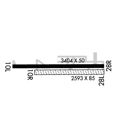
| Rwy | Rwy | |||||||
| 3404x50 | 3404' | 3404x50 | 3138' | |||||
| 2550x60 | 2550' | 2550x60 | 2550' | |||||
| Runway ID | Single Wheel | Double Wheel | Double Tandem Wheel | Dual Double Wheel |
| 10L/28R | 8,000 | N/A | N/A | N/A |
| 10R/28L | N/A | N/A | N/A | N/A |
| These numbers are Advisory and are not limits. The Airport Manager should have more accurate Weight Limits | ||||
 Airport Diagram might not be current. | |
| Facility Name: | SALEM AIRPARK INC |
| City Name: | SALEM |
| County: | MAHONING |
| State abbrev: | OH |
| State Name: | OHIO |
| Ownership: | PRIVATELY OWNED |
| Use: | OPEN TO THE PUBLIC |
| Owner's Name: | MICHAEL PIDGEON |
| Address: | 11718 SALEM WARREN RD |
| SALEM, OH 44460-9667 | |
| Owner's Phone: | 330-332-4400 |
| Manager's Name: | MICHAEL PIDGEON; SALEMAIRPARK@YAHOO.COM. |
| Address: | 11718 SALEM WARREN RD |
| SALEM, OH 44460-9667 | |
| Phone: | 330-402-1136 |
| FAA Region: | GREAT LAKES |
| FAA Field Office: | DET |
| Date | Sunrise | Sunset |
|---|---|---|
| 09/24/21 Friday | 7:13 | 19:18 |
| 09/25/21 Saturday | 7:14 | 19:16 |
| 09/26/21 Sunday | 7:15 | 19:14 |
| 09/27/21 Monday | 7:16 | 19:13 |
| 09/28/21 Tuesday | 7:17 | 19:11 |
| 09/29/21 Wednesday | 7:18 | 19:09 |
| 09/30/21 Thursday | 7:19 | 19:08 |
| 10/01/21 Friday | 7:20 | 19:06 |
| 10/02/21 Saturday | 7:21 | 19:04 |
| 10/03/21 Sunday | 7:22 | 19:03 |
| 10/04/21 Monday | 7:23 | 19:01 |
| 10/05/21 Tuesday | 7:24 | 18:59 |
| 10/06/21 Wednesday | 7:25 | 18:58 |
| 10/07/21 Thursday | 7:26 | 18:56 |
| Airport Attendance Schedule | UNATTENDED |
| Airport Status | OPERATIONAL (This Status can change at any time - please check NOTAMS) |
| Airport Lighting Schedule | ACTVT NSTD LIRL RWY 10L/28R - CTAF. |
| Airport Storage Available | Tie Downs, Hanger |
| Extra Services Available | NONE |
| Wind Indicator | YES - (unlit) |
| Control Tower | NO |
| CTAF Frequency | 122.700 |
| Unicom Frequency | 122.700 |
| Rotating Beacon Color | |
| Segmented Circle | NO |
| Landing Fee | YES |
| Airport Inspected | STATE - performed by PRIVATE CONTRACT PERSONNEL |
| Inspection Date | 07/24/2020 |
| Type of Fuel Available | Grade 100LL |
| Airframe Repair Service | NONE |
| Power Plant Repair Service | NONE |
| Latitude | N4056.9 |
| Longitude | W08051.7 (ESTIMATED) |
| Arpt Elevation | 1162ft (ESTIMATED) |
| Magnetic Variation | 07W |
| 3 miles N | of SALEM |
| Traffic Pattern Altitude | |
| Sectional Chart | DETROIT |
| Operations (Reported) | Yearly | Avg. Daily |
|---|---|---|
| General Aviation Transient | 200 | 1 |
| General Aviation Local | 5400 | 15 |
| Air Taxi | 0 | 0 |
| Commerical | 0 | 0 |
| Commuter | 0 | 0 |
| Military | 0 | 0 |
| Aircraft based on Field | |
|---|---|
| General Aviation Singles | 66 |
| General Aviation Multi | 0 |
| Jet Aircraft | 0 |
| General Aviation Helicopters | 0 |
| Military Aircraft | 0 |
| Gliders | 0 |
| Ultralights | 0 |
| FSS on field | NO |
| FSS tie-in | CLEVELAND |
| FSS Phone | 1-800-WX-BRIEF |
| Who issues Notams | CLE |
| Notam D service at airport | YES |
| ARTCC Name | CLEVELAND |
| Airport Certification | |
| Aircraft Rescue & Firefighting Index | None |
| Airport of Entry | No |
| Custom Landing Rights | No |
| Joint Civil/Military | No |
| Military Landing rights | No |
| DRAG STRIP 3500 FT SE LOOKS LIKE ARPT. |
| FOR CD CTC CLEVELAND APCH AT 216-352-2323, WHEN APCH CLSD CTC CLEVELAND ARTCC AT 440-774-0223. |
| DEER, BIRDS, & WILDLIFE ON & INVOF ARPT. |
| RWY 10R/28L: CTC AMGR FOR RSCD PRIOR TO USE; TWY CONNECTOR AT E END UNUSBL DUE TO PAVEMENT HEAVE; UNMKD DITCH ON N SIDE. |
| RWY 10L/28R: ONLY 2829 FT AVBL FOR NGT OPS. |
| RWY 28R: ACFT ON TURN FM DNWND TO B MAY BE OBSC BY TREES IN APCH. |
| RWY 10L/ 28RALL PAVEMENT RSTRD ACFT MAX GWT LESS THAN 8000 LBS. |
| RWY 10L/ 28RNSTD LIRL DUE TO LAYOUT & COLORS; 2829 FT LGTD. |
Airport Communications & Frequencies:
| |||||||||||||||||
| Runway: 10L | Runway: 28R | ||
| Mag heading: | 97° | Mag heading: | 277° |
| Rwy Slope: | .26% Up | Rwy Slope: | -.26% Down |
| Approach: | Approach: | ||
| Pattern: | Left Traffic | Pattern: | Left Traffic |
| Markings: | NONSTANDARD | Markings: | NONSTANDARD |
| Marking Condition: | FAIR; NSTD DUE TO YELLOW DTHR. | Marking Condition: | FAIR; NSTD DUE TO YELLOW DTHR. |
| Arresting Dev: | Arresting Dev: | ||
| Lat & Long: | N4056.9 W08052.1 | Lat. & Long.: | N4056.9 W08051.4 |
| Elev: | 1153.0 ft. MSL | Elev: | 1162.0 ft. MSL |
| TCH: | TCH: | ||
| Visual Glide Path: | Visual Glide Path: | ||
| Displaced Threshold: | No | Displaced Threshold: | 266 feet |
| Touchdown Zone: | YES | Touchdown Zone: | YES |
| Touchdown Elev.: | 1160.0 feet | Touchdown Elev.: | 1160.0 feet |
| Visual Glide Slope: | Visual Glide Slope: | ||
| RVR Equipment: | RVR Equipment: | ||
| RVV Equipment: | NO | RVV Equipment: | NO |
| Approach Lights: | Approach Lights: | ||
| REIL: | NO | REIL: | NO |
| Centerline Lights: | NO | Centerline Lights: | NO |
| Touchdown lights: | NO | Touchdown lights: | NO |
| Runway Category: | Runway with a Visual Approach | Runway Category: | Runway with a Visual Approach |
| Declared Distances: | Declared Distances: | ||
| Obstructions: | TREES | Obstructions: | HILL |
| Marked: | NOT Marked/Lighted | Marked: | NOT Marked/Lighted |
| Clearance slope: | 5:1 | Clearance slope: | 16:1; OBST CLNC SLOPE 7:1 TO THR OVR 96 FT TREE, 742 FT DIST, 195 FT L. |
| Obstruction height: | 22 feet AGL | Obstruction height: | 45 feet AGL |
| Dist. from runway: | 322 feet | Dist. from runway: | 950 feet |
| Centerline offset: | 120 left of centerline | Centerline offset: | |
| Comments: | Comments: | +18 FT ROAD, 80 FT DIST, ACRS APCH, 19:1 TO DTHR. |
| Runway: 10R | Runway: 28L | ||
| Mag heading: | 97° | Mag heading: | 277° |
| Rwy Slope: | .35% Up | Rwy Slope: | -.35% Down |
| Approach: | Approach: | ||
| Pattern: | Left Traffic | Pattern: | Left Traffic |
| Markings: | Markings: | ||
| Marking Condition: | RWY END NOT MKD. | Marking Condition: | RWY END NOT MKD. |
| Arresting Dev: | Arresting Dev: | ||
| Lat & Long: | N4056.9 W08052.0 | Lat. & Long.: | N4056.9 W08051.4 |
| Elev: | 1153.0 ft. MSL | Elev: | 1162.0 ft. MSL |
| TCH: | TCH: | ||
| Visual Glide Path: | Visual Glide Path: | ||
| Displaced Threshold: | No | Displaced Threshold: | No |
| Touchdown Zone: | YES | Touchdown Zone: | YES |
| Touchdown Elev.: | 1162.0 feet | Touchdown Elev.: | 1162.0 feet |
| Visual Glide Slope: | Visual Glide Slope: | ||
| RVR Equipment: | RVR Equipment: | ||
| RVV Equipment: | NO | RVV Equipment: | NO |
| Approach Lights: | Approach Lights: | ||
| REIL: | NO | REIL: | NO |
| Centerline Lights: | NO | Centerline Lights: | NO |
| Touchdown lights: | NO | Touchdown lights: | NO |
| Runway Category: | Runway with a Visual Approach | Runway Category: | Runway with a Visual Approach |
| Declared Distances: | Declared Distances: | ||
| Obstructions: | TREES; ALSO 35 FT UNMKD/UNLGTD POLE, 83 FT DIST, 47 FT L. | Obstructions: | ROAD |
| Marked: | NOT Marked/Lighted | Marked: | NOT Marked/Lighted |
| Clearance slope: | Clearance slope: | ||
| Obstruction height: | 85 feet AGL | Obstruction height: | 17 feet AGL |
| Dist. from runway: | 15 feet | Dist. from runway: | 0 feet |
| Centerline offset: | 45 right of centerline | Centerline offset: | 60 feet left of centerline |
| Comments: | Comments: |
Thanks for using FltPlan.com
all rights reserved © 1999-2021 by Flight Plan LLC