
| PADGHAM FIELD ALLEGAN MI |
| |
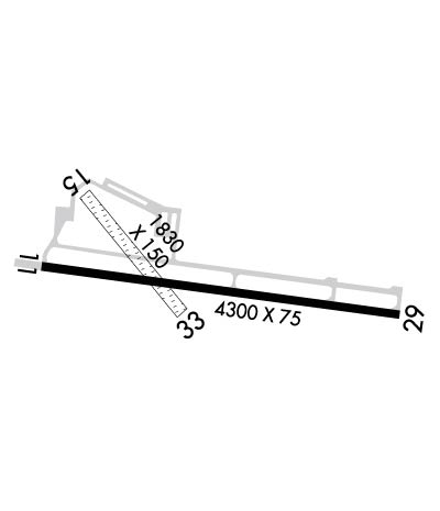
| Lat: N 4231.8 Long: W 08549.4 Elev: 706 Var: +05 Longest Runway: 4300 | ||
| CTAF: 122.8 | ||
| ||||||
|
| Rwy | Rwy | |||||||
| 4300x75 | 4300' | 4300x75 | 4300' | |||||
| 1830x150 | 1300' | 1830x150 | 1830' | |||||
| Runway ID | Single Wheel | Double Wheel | Double Tandem Wheel | Dual Double Wheel |
| 11/29 | 18,000 | N/A | N/A | N/A |
| 15/33 | N/A | N/A | N/A | N/A |
| These numbers are Advisory and are not limits. The Airport Manager should have more accurate Weight Limits | ||||
 Airport Diagram might not be current. | |
| Facility Name: | PADGHAM FLD |
| City Name: | ALLEGAN |
| County: | ALLEGAN |
| State abbrev: | MI |
| State Name: | MICHIGAN |
| Ownership: | PUBLICLY OWNED |
| Use: | OPEN TO THE PUBLIC |
| Owner's Name: | CITY OF ALLEGAN |
| Address: | 112 LOCUST STREET |
| ALLEGAN, MI 49010 | |
| Owner's Phone: | 269-673-5511 |
| Manager's Name: | AARON HASKIN; CITY DPW DIRECTOR. |
| Address: | 112 LOCUST ST |
| ALLEGAN, MI 49010 | |
| Phone: | 269-686-1115; AMGR CELL PH 269-217-7928 |
| FAA Region: | GREAT LAKES |
| FAA Field Office: | DET |
| Date | Sunrise | Sunset |
|---|---|---|
| 09/24/21 Friday | 7:32 | 19:37 |
| 09/25/21 Saturday | 7:34 | 19:36 |
| 09/26/21 Sunday | 7:35 | 19:34 |
| 09/27/21 Monday | 7:36 | 19:32 |
| 09/28/21 Tuesday | 7:37 | 19:30 |
| 09/29/21 Wednesday | 7:38 | 19:29 |
| 09/30/21 Thursday | 7:39 | 19:27 |
| 10/01/21 Friday | 7:40 | 19:25 |
| 10/02/21 Saturday | 7:41 | 19:23 |
| 10/03/21 Sunday | 7:42 | 19:22 |
| 10/04/21 Monday | 7:43 | 19:20 |
| 10/05/21 Tuesday | 7:45 | 19:18 |
| 10/06/21 Wednesday | 7:46 | 19:16 |
| 10/07/21 Thursday | 7:47 | 19:15 |
| Airport Attendance Schedule | 7 Days A Week 0800-1700 |
| Airport Status | OPERATIONAL (This Status can change at any time - please check NOTAMS) |
| Airport Lighting Schedule | ACTVT MIRL RY 11/29; PAPI RYS 11 & 29; REIL RY 11 & 29-CTAF. |
| Airport Storage Available | Tie Downs, Hanger |
| Extra Services Available | Flight Instruction, Parachute Jumping, Aircraft Rental, Aircraft Sales |
| Wind Indicator | YES - (lighted) |
| Control Tower | NO |
| CTAF Frequency | 122.800 |
| Unicom Frequency | 122.800 |
| Rotating Beacon Color | CLEAR-GREEN (Light Land Airport) |
| Segmented Circle | YES |
| Landing Fee | NO |
| Airport Inspected | STATE - performed by STATE AERONAUTICAL PERSONNEL |
| Inspection Date | 05/30/2017 |
| Type of Fuel Available | Grade 100LL |
| Airframe Repair Service | MAJOR; SERVICES: ACE AVIATION 888-588-2755. |
| Power Plant Repair Service | MAJOR |
| Latitude | N4231.8 |
| Longitude | W08549.4 (ESTIMATED) |
| Arpt Elevation | 706ft (SURVEYED) |
| Magnetic Variation | 05W |
| 1 miles E | of ALLEGAN |
| Traffic Pattern Altitude | |
| Sectional Chart | CHICAGO |
| Operations (Reported) | Yearly | Avg. Daily |
|---|---|---|
| General Aviation Transient | 5000 | 14 |
| General Aviation Local | 5000 | 14 |
| Air Taxi | 100 | 0 |
| Commerical | 0 | 0 |
| Commuter | 0 | 0 |
| Military | 0 | 0 |
| Aircraft based on Field | |
|---|---|
| General Aviation Singles | 26 |
| General Aviation Multi | 1 |
| Jet Aircraft | 0 |
| General Aviation Helicopters | 0 |
| Military Aircraft | 0 |
| Gliders | 0 |
| Ultralights | 0 |
| FSS on field | NO |
| FSS tie-in | LANSING |
| FSS Phone | 1-800-WX-BRIEF |
| Who issues Notams | LAN |
| Notam D service at airport | YES |
| ARTCC Name | CHICAGO |
| Airport Certification | |
| Aircraft Rescue & Firefighting Index | None |
| Airport of Entry | No |
| Custom Landing Rights | No |
| Joint Civil/Military | No |
| Military Landing rights | YES |
| NATIONAL PLAN OF INTEGRATED AIRPORT SYSTEMS (NPIAS) |
| GRANT AGREEMENTS UNDER FAAP/ADAP/AIP |
| ASSURANCES PURSUANT TO TITLE VI, CIVIL RIGHTS ACT OF 1964 |
| ADMIN BLDG ACCESS, PRESS 5-3-2-1. |
| SKYDIVING ACTIVITY THU - SUN. |
| FOR CD CTC GREAT LAKES APCH AT 269-459-3344, WHEN APCH CLSD CTC CHICAGO ARTCC AT 630-906-8921. |
| RWY 11/2 9 RWY CONDS NOT MONITORED AT NIGHT. |
| RWY 15/3 3 CLSD NOV 15 THRU MAR & WHEN SNOW COVERED. |
Airport Communications & Frequencies:
| |||||||||||||||||
| Runway: 11 | Runway: 29 | ||
| Mag heading: | 103° | Mag heading: | 283° |
| Rwy Slope: | -.02% Down | Rwy Slope: | .02% Up |
| Approach: | Approach: | ||
| Pattern: | Left Traffic | Pattern: | Left Traffic |
| Markings: | NONPRECISION INSTRUMENT | Markings: | NONPRECISION INSTRUMENT |
| Marking Condition: | FAIR | Marking Condition: | FAIR |
| Arresting Dev: | Arresting Dev: | ||
| Lat & Long: | N4231.9 W08549.8 | Lat. & Long.: | N4231.8 W08548.9 |
| Elev: | 703.6 ft. MSL | Elev: | 702.7 ft. MSL |
| TCH: | 40 ft. AGL | TCH: | 40 ft. AGL |
| Visual Glide Path: | 3.00 degrees | Visual Glide Path: | 3.00 degrees |
| Displaced Threshold: | No | Displaced Threshold: | No |
| Touchdown Zone: | YES | Touchdown Zone: | YES |
| Touchdown Elev.: | 705.6 feet | Touchdown Elev.: | 705.3 feet |
| Visual Glide Slope: | 4-Light PAPI on LEFT side of Runway | Visual Glide Slope: | 4-Light PAPI on LEFT side of Runway |
| RVR Equipment: | RVR Equipment: | ||
| RVV Equipment: | NO | RVV Equipment: | NO |
| Approach Lights: | Approach Lights: | ||
| REIL: | YES | REIL: | YES |
| Centerline Lights: | NO | Centerline Lights: | NO |
| Touchdown lights: | NO | Touchdown lights: | NO |
| Runway Category: | Runway with a Non-precision Approach | Runway Category: | Runway with a Non-precision Approach |
| Declared Distances: | Declared Distances: | ||
| Obstructions: | TREES | Obstructions: | TREES |
| Marked: | NOT Marked/Lighted | Marked: | NOT Marked/Lighted |
| Clearance slope: | 20:1 | Clearance slope: | 20:1 |
| Obstruction height: | 54 feet AGL | Obstruction height: | 60 feet AGL |
| Dist. from runway: | 1280 feet | Dist. from runway: | 1400 feet |
| Centerline offset: | Centerline offset: | 270 feet right of centerline | |
| Comments: | Comments: |
| Runway: 15 | Runway: 33 | ||
| Mag heading: | 145° | Mag heading: | 325° |
| Rwy Slope: | .20% Up | Rwy Slope: | -.20% Down |
| Approach: | Approach: | ||
| Pattern: | Left Traffic | Pattern: | Left Traffic |
| Markings: | NONE | Markings: | NONE |
| Marking Condition: | RY 15/33 MKD WITH 3 FT YELLOW CONES. | Marking Condition: | |
| Arresting Dev: | Arresting Dev: | ||
| Lat & Long: | N4232.0 W08549.7 | Lat. & Long.: | N4231.8 W08549.5 |
| Elev: | 700.0 ft. MSL | Elev: | 703.6 ft. MSL |
| TCH: | TCH: | ||
| Visual Glide Path: | Visual Glide Path: | ||
| Displaced Threshold: | 530 feet | Displaced Threshold: | No |
| Touchdown Zone: | YES | Touchdown Zone: | YES |
| Touchdown Elev.: | 705.3 feet | Touchdown Elev.: | 705.3 feet |
| Visual Glide Slope: | Visual Glide Slope: | ||
| RVR Equipment: | RVR Equipment: | ||
| RVV Equipment: | NO | RVV Equipment: | NO |
| Approach Lights: | Approach Lights: | ||
| REIL: | NO | REIL: | NO |
| Centerline Lights: | NO | Centerline Lights: | NO |
| Touchdown lights: | NO | Touchdown lights: | NO |
| Runway Category: | Runway with a Visual Approach | Runway Category: | Runway with a Visual Approach |
| Declared Distances: | Declared Distances: | ||
| Obstructions: | TREES | Obstructions: | TREES |
| Marked: | NOT Marked/Lighted | Marked: | NOT Marked/Lighted |
| Clearance slope: | 14:1; APCH RATIO 20:1 TO DSPLCD THLD. | Clearance slope: | 2:1; APCH RATIO 20:1 BASED ON STRAIGHT OUT OVR 85 FT TREES, 1700 FT DSTC. |
| Obstruction height: | 80 feet AGL | Obstruction height: | 45 feet AGL |
| Dist. from runway: | 1150 feet | Dist. from runway: | 95 feet |
| Centerline offset: | Centerline offset: | 100 feet left of centerline | |
| Comments: | Comments: |
Thanks for using FltPlan.com
all rights reserved © 1999-2021 by Flight Plan LLC
