| UNION COUNTY, TROY SHELTON FLD UNION SC |
| |
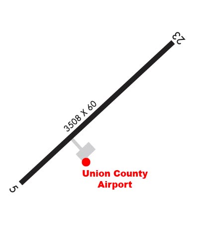
| Lat: N 3441.2 Long: W 08138.5 Elev: 610 Var: +06 Longest Runway: 3508 | ||
| CTAF: 122.7 | ||
| |||||||||||||||||||||||
| |||||||||||||||||||||||
| Rwy | Rwy | |||||||
| 3508x60 | 3508' | 3508x60 | 3508' | |||||
| Runway ID | Single Wheel | Double Wheel | Double Tandem Wheel | Dual Double Wheel |
| 05/23 | 12,500 | N/A | N/A | N/A |
| These numbers are Advisory and are not limits. The Airport Manager should have more accurate Weight Limits | ||||
 Airport Diagram might not be current. | |
| Facility Name: | UNION COUNTY, TROY SHELTON FLD |
| City Name: | UNION |
| County: | UNION |
| State abbrev: | SC |
| State Name: | SOUTH CAROLINA |
| Ownership: | PUBLICLY OWNED |
| Use: | OPEN TO THE PUBLIC |
| Owner's Name: | UNION COUNTY |
| Address: | PO DRAWER G |
| UNION, SC 29379 | |
| Owner's Phone: | 864-429-1600 |
| Manager's Name: | RONNIE WADE |
| Address: | UNION COUNTY AIRPORT, 198 AIRPORT RD |
| UNION, SC 29379 | |
| Phone: | 864-429-1680 |
| FAA Region: | SOUTHERN |
| FAA Field Office: | ATL |
| Date | Sunrise | Sunset |
|---|---|---|
| 06/08/26 Monday | 6:13 | 20:38 |
| 06/09/26 Tuesday | 6:13 | 20:39 |
| 06/10/26 Wednesday | 6:13 | 20:39 |
| 06/11/26 Thursday | 6:13 | 20:40 |
| 06/12/26 Friday | 6:13 | 20:40 |
| 06/13/26 Saturday | 6:13 | 20:40 |
| 06/14/26 Sunday | 6:13 | 20:41 |
| 06/15/26 Monday | 6:13 | 20:41 |
| 06/16/26 Tuesday | 6:13 | 20:41 |
| 06/17/26 Wednesday | 6:13 | 20:42 |
| 06/18/26 Thursday | 6:13 | 20:42 |
| 06/19/26 Friday | 6:13 | 20:42 |
| 06/20/26 Saturday | 6:14 | 20:43 |
| 06/21/26 Sunday | 6:14 | 20:43 |
| Airport Attendance Schedule | MON-FRI 0800-1700 |
| Airport Status | OPERATIONAL (This Status can change at any time - please check NOTAMS) |
| Airport Lighting Schedule | REIL RWY 23 OPR PHOTOCELL. MIRL RWY 05/23 PRESET MED INTST DUSK-0000; AFTER 0000 ACTVT - CTAF. ACTVT PAPI RWY 05 & 23 - CTAF. |
| Airport Storage Available | Tie Downs, Hanger |
| Extra Services Available | NONE |
| Wind Indicator | YES - (lighted) |
| Control Tower | NO |
| CTAF Frequency | 122.700 |
| Unicom Frequency | 122.700 |
| Rotating Beacon Color | WG |
| Segmented Circle | YES |
| Landing Fee | NO |
| Airport Inspected | STATE - performed by STATE AERONAUTICAL PERSONNEL |
| Inspection Date | 09/18/2024 |
| Type of Fuel Available | Grade 100LL; -10SELF-SERVE FUEL AVBL 24 HRS. FOR SVC AFT HRS CALL 864-426-3003. |
| Airframe Repair Service | MAJOR |
| Power Plant Repair Service | MAJOR |
| Latitude | N3441.2 |
| Longitude | W08138.5 (ESTIMATED) |
| Arpt Elevation | 609ft (SURVEYED) |
| Magnetic Variation | 06W |
| 1 miles SW | of UNION |
| Traffic Pattern Altitude | |
| Sectional Chart | ATLANTA |
| Operations (Reported) | Yearly | Avg. Daily |
|---|---|---|
| General Aviation Transient | 0 | 0 |
| General Aviation Local | 0 | 0 |
| Air Taxi | 0 | 0 |
| Commerical | 0 | 0 |
| Commuter | 0 | 0 |
| Military | 0 | 0 |
| Aircraft based on Field | |
|---|---|
| General Aviation Singles | 0 |
| General Aviation Multi | 0 |
| Jet Aircraft | 0 |
| General Aviation Helicopters | 0 |
| Military Aircraft | 0 |
| Gliders | 0 |
| Ultralights | 0 |
| FSS on field | NO |
| FSS tie-in | ANDERSON |
| FSS Phone | 1-800-WX-BRIEF |
| Who issues Notams | AND |
| Notam D service at airport | YES |
| ARTCC Name | ATLANTA |
| Airport Certification | |
| Aircraft Rescue & Firefighting Index | None |
| Airport of Entry | No |
| Custom Landing Rights | No |
| Joint Civil/Military | No |
| Military Landing rights | YES |
| NATIONAL PLAN OF INTEGRATED AIRPORT SYSTEMS (NPIAS) |
| GRANT AGREEMENTS UNDER FAAP/ADAP/AIP |
| ASSURANCES PURSUANT TO TITLE VI, CIVIL RIGHTS ACT OF 1964 |
| FOR CD CTC GREER APCH AT 864-877-8275. WHEN GREER APCH CLSD, FOR CD CTC ATLANTA ARTCC AT 770-210-7692. |
Airport Communications & Frequencies:
| |||||||||||||||||
| Runway: 05 | Runway: 23 | ||
| Mag heading: | 53° | Mag heading: | 233° |
| Rwy Slope: | 1.04% Up | Rwy Slope: | -1.04% Down |
| Approach: | Approach: | ||
| Pattern: | Left Traffic | Pattern: | Left Traffic |
| Markings: | NONPRECISION INSTRUMENT | Markings: | BASIC |
| Marking Condition: | GOOD | Marking Condition: | GOOD |
| Arresting Dev: | Arresting Dev: | ||
| Lat & Long: | N3441.0 W08138.7 | Lat. & Long.: | N3441.4 W08138.2 |
| Elev: | 573.2 ft. MSL | Elev: | 609.8 ft. MSL |
| TCH: | 40 ft. AGL | TCH: | 38 ft. AGL |
| Visual Glide Path: | 4.00 degrees | Visual Glide Path: | 4.00 degrees |
| Displaced Threshold: | No | Displaced Threshold: | No |
| Touchdown Zone: | YES | Touchdown Zone: | YES |
| Touchdown Elev.: | 604.9 feet | Touchdown Elev.: | 609.9 feet |
| Visual Glide Slope: | 2-Light PAPI on LEFT side of Runway | Visual Glide Slope: | 2-Light PAPI on LEFT side of Runway |
| RVR Equipment: | RVR Equipment: | ||
| RVV Equipment: | NO | RVV Equipment: | NO |
| Approach Lights: | Approach Lights: | ||
| REIL: | NO | REIL: | YES |
| Centerline Lights: | NO | Centerline Lights: | NO |
| Touchdown lights: | NO | Touchdown lights: | NO |
| Runway Category: | Runway with a Non-precision Approach | Runway Category: | Runway with a Non-precision Approach |
| Declared Distances: | Declared Distances: | ||
| Comments: | TREES CLOSE-IN, 142 FT FROM RWY END BOTH SIDES OF RWY 5 APCH 112 FT FROM CNTRLN. | Comments: |
Thanks for using FltPlan.com
all rights reserved © 1999-2026 by Flight Plan LLC