| WALDEN-JACKSON COUNTY WALDEN CO |
| |
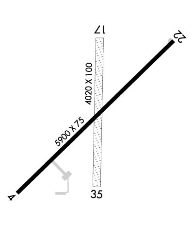
| Lat: N 4045.0 Long: W 10616.3 Elev: 8154 Var: -10 Longest Runway: 5900 | ||
| AWOS: 118.62 CTAF: 122.9 | ||
| |||||||||||||||||||||||
| |||||||||||||||||||||||
| |||||||||||||||||||||||
| Rwy | Rwy | |||||||
| 5900x75 | 5900' | 5900x75 | 5900' | |||||
| 4020x100 | 4020' | 4020x100 | 4020' | |||||
| Runway ID | Single Wheel | Double Wheel | Double Tandem Wheel | Dual Double Wheel |
| 04/22 | 25,000 | N/A | N/A | N/A |
| 17/35 | N/A | N/A | N/A | N/A |
| These numbers are Advisory and are not limits. The Airport Manager should have more accurate Weight Limits | ||||
 Airport Diagram might not be current. | |
| Facility Name: | WALDEN-JACKSON COUNTY |
| City Name: | WALDEN |
| County: | JACKSON |
| State abbrev: | CO |
| State Name: | COLORADO |
| Ownership: | PUBLICLY OWNED |
| Use: | OPEN TO THE PUBLIC |
| Owner's Name: | JACKSON COUNTY |
| Address: | CO COURTHOUSE PO BOX 1019 |
| WALDEN, CO 80480 | |
| Owner's Phone: | 970-723-4660 |
| Manager's Name: | KENT CROWDER |
| Address: | P. O. BOX 1019 |
| WALDEN, CO 80480 | |
| Phone: | 970-723-4660 |
| FAA Region: | NORTHWEST MOUNTAIN |
| FAA Field Office: | DEN |

| Date | Sunrise | Sunset |
|---|---|---|
| 09/24/21 Friday | 6:54 | 18:59 |
| 09/25/21 Saturday | 6:55 | 18:57 |
| 09/26/21 Sunday | 6:56 | 18:56 |
| 09/27/21 Monday | 6:57 | 18:54 |
| 09/28/21 Tuesday | 6:58 | 18:52 |
| 09/29/21 Wednesday | 6:59 | 18:51 |
| 09/30/21 Thursday | 7:00 | 18:49 |
| 10/01/21 Friday | 7:01 | 18:47 |
| 10/02/21 Saturday | 7:02 | 18:46 |
| 10/03/21 Sunday | 7:03 | 18:44 |
| 10/04/21 Monday | 7:04 | 18:42 |
| 10/05/21 Tuesday | 7:06 | 18:41 |
| 10/06/21 Wednesday | 7:07 | 18:39 |
| 10/07/21 Thursday | 7:08 | 18:38 |
| Airport Attendance Schedule | ON CALL; ATTENDED ON CALL. PHONE 970-723-4660 OR 970-723-4481 OR 970-846-6971. |
| Airport Status | OPERATIONAL (This Status can change at any time - please check NOTAMS) |
| Airport Lighting Schedule | ACTVT MIRL RY 04/22, PAPI RY 04 & RY 22 - CTAF. |
| Airport Storage Available | Tie Downs |
| Extra Services Available | NONE |
| Wind Indicator | YES - (lighted) |
| Control Tower | NO |
| CTAF Frequency | 122.900 |
| Unicom Frequency | |
| Rotating Beacon Color | CLEAR-GREEN (Light Land Airport) |
| Segmented Circle | YES; SEGMENTED CIRCLE MKD WITH YELLOW & BLACK TIRES. |
| Landing Fee | NO |
| Airport Inspected | STATE - performed by STATE AERONAUTICAL PERSONNEL |
| Inspection Date | 07/29/2019 |
| Type of Fuel Available | None |
| Airframe Repair Service | NONE |
| Power Plant Repair Service | NONE |
| Latitude | N4045.0 |
| Longitude | W10616.3 (ESTIMATED) |
| Arpt Elevation | 8153ft (SURVEYED) |
| Magnetic Variation | 10E |
| 1 miles NE | of WALDEN |
| Traffic Pattern Altitude | |
| Sectional Chart | CHEYENNE |
| Operations (Reported) | Yearly | Avg. Daily |
|---|---|---|
| General Aviation Transient | 800 | 2 |
| General Aviation Local | 200 | 1 |
| Air Taxi | 0 | 0 |
| Commerical | 0 | 0 |
| Commuter | 0 | 0 |
| Military | 0 | 0 |
| Aircraft based on Field | |
|---|---|
| General Aviation Singles | 8 |
| General Aviation Multi | 0 |
| Jet Aircraft | 1 |
| General Aviation Helicopters | 0 |
| Military Aircraft | 0 |
| Gliders | 0 |
| Ultralights | 0 |
| FSS on field | NO |
| FSS tie-in | DENVER |
| FSS Phone | 1-800-WX-BRIEF |
| Who issues Notams | DEN |
| Notam D service at airport | YES |
| ARTCC Name | DENVER |
| Airport Certification | |
| Aircraft Rescue & Firefighting Index | None |
| Airport of Entry | No |
| Custom Landing Rights | No |
| Joint Civil/Military | No |
| Military Landing rights | YES |
| GRANT AGREEMENTS UNDER FAAP/ADAP/AIP |
| ASSURANCES PURSUANT TO TITLE VI, CIVIL RIGHTS ACT OF 1964 |
| RWY 35 +4 FT FENCE AT THR 0B; YELLOW PAINT AT TOPS OF FENCE POSTS EXTREMELY WORN, FADED AND DIFFICULT TO DETECT. |
| RWY 17 HAS 6 FT METAL POLE 100 FT FROM THLD, 10 FT LEFT OF RWY EDGE. |
| RWY 35 PUB ROAD 24 FT FROM THLD, TREES 300 FT FROM THLD +38 FT, 154 FT RIGHT OF APCH. |
| OCCASIONAL DEER & ANTELOPE ON RUNWAYS. |
| RWY 04 HAS -50 FT DROPOFF 450 FT FM THLD. |
| RADIO CONTROLLED MODEL ACFT OPERATE ON ARPT AT SE CORNER. |
| RESTROOMS AVBL MAY-SEP ON ARPT. |
| RWY 04 +20' POWERLINE 660' FROM RWY END 750' L OF EXTD CNTRLN. |
| FOR CD CTC DENVER ARTCC AT 303-651-4257. |
Airport Communications & Frequencies:
| |||||||
| Runway: 04 | Runway: 22 | ||
| Mag heading: | 35° | Mag heading: | 215° |
| Rwy Slope: | -.05% Down | Rwy Slope: | .05% Up |
| Approach: | Approach: | ||
| Pattern: | Left Traffic | Pattern: | Left Traffic |
| Markings: | NONPRECISION INSTRUMENT | Markings: | NONPRECISION INSTRUMENT |
| Marking Condition: | GOOD | Marking Condition: | GOOD |
| Arresting Dev: | Arresting Dev: | ||
| Lat & Long: | N4044.7 W10616.8 | Lat. & Long.: | N4045.3 W10615.8 |
| Elev: | 8153.1 ft. MSL | Elev: | 8150.0 ft. MSL |
| TCH: | 35 ft. AGL | TCH: | 35 ft. AGL |
| Visual Glide Path: | 3.00 degrees | Visual Glide Path: | 3.00 degrees |
| Displaced Threshold: | No | Displaced Threshold: | No |
| Touchdown Zone: | YES | Touchdown Zone: | YES |
| Touchdown Elev.: | 8153.3 feet | Touchdown Elev.: | 8152.0 feet |
| Visual Glide Slope: | 4-Light PAPI on LEFT side of Runway | Visual Glide Slope: | 4-Light PAPI on LEFT side of Runway |
| RVR Equipment: | RVR Equipment: | ||
| RVV Equipment: | NO | RVV Equipment: | NO |
| Approach Lights: | Approach Lights: | ||
| REIL: | NO | REIL: | NO |
| Centerline Lights: | NO | Centerline Lights: | NO |
| Touchdown lights: | NO | Touchdown lights: | NO |
| Runway Category: | Runway with a Visual Approach | Runway Category: | Runway with a Visual Approach |
| Declared Distances: | Declared Distances: | ||
| Comments: | Comments: | RY 22 +4FT BRUSH 10 FT FROM APCH END. |
| Runway: 17 | Runway: 35 | ||
| Mag heading: | 171° | Mag heading: | 351° |
| Rwy Slope: | .37% Up | Rwy Slope: | -.37% Down |
| Approach: | Approach: | ||
| Pattern: | Left Traffic | Pattern: | Left Traffic |
| Markings: | Markings: | ||
| Marking Condition: | RWY 17 RY 17/35 MKD WITH INOPERABLE RY EDGE LIGHTS & ORANGE CONES; RY 22 NUMBER LCTD 125 FT FM PAVEMENT END. | Marking Condition: | |
| Arresting Dev: | Arresting Dev: | ||
| Lat & Long: | N4045.4 W10616.3 | Lat. & Long.: | N4044.7 W10616.3 |
| Elev: | 8138.6 ft. MSL | Elev: | 8153.6 ft. MSL |
| TCH: | TCH: | ||
| Visual Glide Path: | Visual Glide Path: | ||
| Displaced Threshold: | No | Displaced Threshold: | No |
| Touchdown Zone: | YES | Touchdown Zone: | YES |
| Touchdown Elev.: | 8149.5 feet | Touchdown Elev.: | 8153.8 feet |
| Visual Glide Slope: | Visual Glide Slope: | ||
| RVR Equipment: | RVR Equipment: | ||
| RVV Equipment: | NO | RVV Equipment: | NO |
| Approach Lights: | Approach Lights: | ||
| REIL: | NO | REIL: | NO |
| Centerline Lights: | NO | Centerline Lights: | NO |
| Touchdown lights: | NO | Touchdown lights: | NO |
| Runway Category: | Runway with a Visual Approach | Runway Category: | Runway with a Visual Approach |
| Declared Distances: | Declared Distances: | ||
| Obstructions: | FENCE | Obstructions: | ROAD |
| Marked: | MARKED; RWY 17/35 YELLOW PAINT AT TOPS OF FENCE POSTS EXTREMELY WORN, FADED AND DIFFICULT TO DETECT. | Marked: | NOT Marked/Lighted |
| Clearance slope: | Clearance slope: | ||
| Obstruction height: | 4 feet AGL | Obstruction height: | 10 feet AGL |
| Dist. from runway: | 0 feet | Dist. from runway: | 0 feet |
| Centerline offset: | Centerline offset: | ||
| Comments: | Comments: |
Thanks for using FltPlan.com
all rights reserved © 1999-2021 by Flight Plan LLC