
| ST. MARY'S COUNTY RGNL LEONARDTOWN MD |
| |
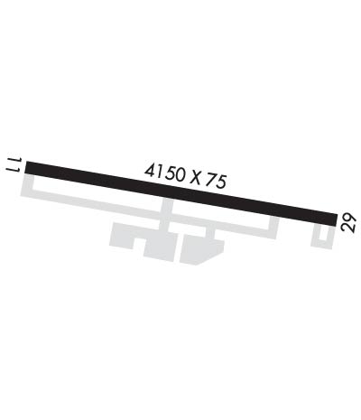
| Lat: N 3818.9 Long: W 07633.0 Elev: 142 Var: +10 Longest Runway: 4150 | ||
| AWOS: 119.57 CTAF: 123.0 | ||
| ||||||
| ||||||
|
| Rwy | Rwy | |||||||
| 4150x75 | 4150' | 4150x75 | 4150' | |||||
| Runway ID | Single Wheel | Double Wheel | Double Tandem Wheel | Dual Double Wheel |
| 11/29 | 12,500 | N/A | N/A | N/A |
| These numbers are Advisory and are not limits. The Airport Manager should have more accurate Weight Limits | ||||
 Airport Diagram might not be current. | |
| Facility Name: | ST MARY'S COUNTY RGNL |
| City Name: | LEONARDTOWN |
| County: | ST MARYS |
| State abbrev: | MD |
| State Name: | MARYLAND |
| Ownership: | PUBLICLY OWNED |
| Use: | OPEN TO THE PUBLIC |
| Owner's Name: | THE COMMISSIONERS OF ST. MARYS CO. |
| Address: | P.O. BOX 653, 41770 BALDRIDGE STREET |
| LEONARDTOWN, MD 20650 | |
| Owner's Phone: | 301-475-4200; EXT 1320 |
| Manager's Name: | ALLISON SWINT |
| Address: | 44825 ST ANDREWS CHURCH ROAD; AIRPORT'S PHYSICAL ADDRESS IS 44200 AIRPORT ROAD, CALIFORNIA, MD 20619 |
| CALIFORNIA, MD 20619 | |
| Phone: | (301) 475-4200; EXT 73511 |
| FAA Region: | EASTERN |
| FAA Field Office: | DCA |
| Date | Sunrise | Sunset |
|---|---|---|
| 09/24/21 Friday | 6:55 | 19:00 |
| 09/25/21 Saturday | 6:56 | 18:59 |
| 09/26/21 Sunday | 6:57 | 18:57 |
| 09/27/21 Monday | 6:58 | 18:56 |
| 09/28/21 Tuesday | 6:59 | 18:54 |
| 09/29/21 Wednesday | 7:00 | 18:53 |
| 09/30/21 Thursday | 7:01 | 18:51 |
| 10/01/21 Friday | 7:02 | 18:49 |
| 10/02/21 Saturday | 7:03 | 18:48 |
| 10/03/21 Sunday | 7:04 | 18:46 |
| 10/04/21 Monday | 7:04 | 18:45 |
| 10/05/21 Tuesday | 7:05 | 18:43 |
| 10/06/21 Wednesday | 7:06 | 18:42 |
| 10/07/21 Thursday | 7:07 | 18:40 |
| Airport Attendance Schedule | 7 Days A Week 0800-1700 |
| Airport Status | OPERATIONAL (This Status can change at any time - please check NOTAMS) |
| Airport Lighting Schedule | ACTVT REIL RWYS 11 & 29; MIRL RWY 11/29 - CTAF. |
| Airport Storage Available | Tie Downs |
| Extra Services Available | Air Freight, Air Ambulance, Avionics, Charter, Flight Instruction, Aircraft Rental, Aircraft Sales |
| Wind Indicator | YES - (lighted) |
| Control Tower | NO |
| CTAF Frequency | 123.000 |
| Unicom Frequency | 123.000 |
| Rotating Beacon Color | CLEAR-GREEN (Light Land Airport) |
| Segmented Circle | YES |
| Landing Fee | NO |
| Airport Inspected | STATE - performed by STATE AERONAUTICAL PERSONNEL |
| Inspection Date | 04/15/2021 |
| Type of Fuel Available | Grade 100LL, JET A (freeze point -40C); -10SELF SERVE 100LL AVBL WITH CREDIT CARD. |
| Airframe Repair Service | MAJOR |
| Power Plant Repair Service | MAJOR |
| Latitude | N3818.9 |
| Longitude | W07633.0 (ESTIMATED) |
| Arpt Elevation | 141ft (SURVEYED) |
| Magnetic Variation | 10W |
| 4 miles NE | of LEONARDTOWN |
| Traffic Pattern Altitude | |
| Sectional Chart | WASHINGTON |
| Operations (Reported) | Yearly | Avg. Daily |
|---|---|---|
| General Aviation Transient | 15586 | 43 |
| General Aviation Local | 23380 | 64 |
| Air Taxi | 1126 | 3 |
| Commerical | 0 | 0 |
| Commuter | 0 | 0 |
| Military | 216 | 1 |
| Aircraft based on Field | |
|---|---|
| General Aviation Singles | 165 |
| General Aviation Multi | 13 |
| Jet Aircraft | 4 |
| General Aviation Helicopters | 5 |
| Military Aircraft | 0 |
| Gliders | 7 |
| Ultralights | 1 |
| FSS on field | NO |
| FSS tie-in | LEESBURG |
| FSS Phone | 1-800-WX-BRIEF |
| Who issues Notams | DCA |
| Notam D service at airport | YES |
| ARTCC Name | WASHINGTON |
| Airport Certification | |
| Aircraft Rescue & Firefighting Index | None |
| Airport of Entry | No |
| Custom Landing Rights | No |
| Joint Civil/Military | No |
| Military Landing rights | YES |
| NATIONAL PLAN OF INTEGRATED AIRPORT SYSTEMS (NPIAS) |
| GRANT AGREEMENTS UNDER FAAP/ADAP/AIP |
| ASSURANCES PURSUANT TO TITLE VI, CIVIL RIGHTS ACT OF 1964 |
| THIS AIRPORT HAS BEEN SURVEYED BY THE NATIONAL GEODETIC SURVEY. |
| DEER ON & INVOF RY 11/29 SS-SR. |
| GLIDER AND ULTRALIGHT ACTIVITY ON & INVOF ARPT. |
| RY 29 15 FT DEPRESSION (DOWNSLOPE) 300 FT FM THLD 150 FT R-125 L. |
| FOR CD WHEN NHK APCH IS CLSD CTC POTOMAC APCH AT 866-640-4124. |
| WHEN R-4007 IN EFFECT, ACFT OPRNG VFR AT ARPT MUST RMN WITHIN 1.5 NM OF ARPT, AT OR BLW 1500 FT MSL, AND ABV 700 FT AGL. |
| ALL VFR FLT OPS CONDUCTED WI R-4007 SHALL BE AT OR BLW 1000 FT MSL. IFR AND VFR APCHS WI R-4007 WILL BE COORDD WITH PATUXENT APCH ON 121.0 OR BY PHONE 301-342-3740. |
Airport Communications & Frequencies:
| |||||||||||||||||||||||||
| Runway: 11 | Runway: 29 | ||
| Mag heading: | 112° | Mag heading: | 292° |
| Rwy Slope: | -.40% Down | Rwy Slope: | .40% Up |
| Approach: | Approach: | ||
| Pattern: | Left Traffic | Pattern: | Left Traffic |
| Markings: | NONPRECISION INSTRUMENT | Markings: | NONPRECISION INSTRUMENT |
| Marking Condition: | FAIR | Marking Condition: | FAIR |
| Arresting Dev: | Arresting Dev: | ||
| Lat & Long: | N3819.0 W07633.4 | Lat. & Long.: | N3818.8 W07632.6 |
| Elev: | 141.8 ft. MSL | Elev: | 125.1 ft. MSL |
| TCH: | 37 ft. AGL | TCH: | 32 ft. AGL |
| Visual Glide Path: | 3.00 degrees | Visual Glide Path: | 3.00 degrees |
| Displaced Threshold: | No | Displaced Threshold: | No |
| Touchdown Zone: | YES | Touchdown Zone: | YES |
| Touchdown Elev.: | 141.8 feet | Touchdown Elev.: | 137.0 feet |
| Visual Glide Slope: | 2-Light PAPI on LEFT side of Runway | Visual Glide Slope: | 2-Light PAPI on LEFT side of Runway |
| RVR Equipment: | RVR Equipment: | ||
| RVV Equipment: | NO | RVV Equipment: | NO |
| Approach Lights: | Approach Lights: | ||
| REIL: | YES | REIL: | YES |
| Centerline Lights: | NO | Centerline Lights: | NO |
| Touchdown lights: | NO | Touchdown lights: | NO |
| Runway Category: | Runway with a Non-precision Approach | Runway Category: | Runway with a Non-precision Approach |
| Declared Distances: | Declared Distances: | ||
| Obstructions: | TREES | Obstructions: | TREES |
| Marked: | NOT Marked/Lighted | Marked: | NOT Marked/Lighted |
| Clearance slope: | 10:1 | Clearance slope: | 26:1 |
| Obstruction height: | 38 feet AGL | Obstruction height: | 84 feet AGL |
| Dist. from runway: | 617 feet | Dist. from runway: | 2455 feet |
| Centerline offset: | 212 left of centerline | Centerline offset: | 258 feet right of centerline |
| Comments: | 28 FT TREES AT THLD, 160 FT L. | Comments: |
Thanks for using FltPlan.com
all rights reserved © 1999-2021 by Flight Plan LLC
