
| MARYLAND INDIAN HEAD MD |
| |
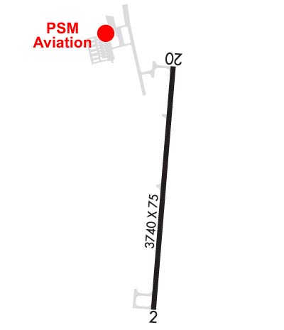
| Lat: N 3835.8 Long: W 07704.3 Elev: 175 Var: +09 Longest Runway: 3740 | ||
| CTAF: 122.7 | ||
| |||||||||||||||||||||||
| |||||||||||||||||||||||
| Rwy | Rwy | |||||||
| 3740x75 | 3740' | 3740x75 | 3740' | |||||
| Runway ID | Single Wheel | Double Wheel | Double Tandem Wheel | Dual Double Wheel |
| 02/20 | N/A | N/A | N/A | N/A |
| These numbers are Advisory and are not limits. The Airport Manager should have more accurate Weight Limits | ||||
 Airport Diagram might not be current. | |
| Facility Name: | MARYLAND |
| City Name: | INDIAN HEAD |
| County: | CHARLES |
| State abbrev: | MD |
| State Name: | MARYLAND |
| Ownership: | PRIVATELY OWNED |
| Use: | OPEN TO THE PUBLIC |
| Owner's Name: | PSM AVIATION LLC |
| Address: | 3900 LIVINGSTON RD, |
| INDIAN HEAD, MD 20640 | |
| Owner's Phone: | 301-283-6202 |
| Manager's Name: | SHEEL PATEL |
| Address: | 3900 LIVINGSTON RD |
| INDIAN HEAD, MD 20640 | |
| Phone: | 301-283-6202 |
| FAA Region: | EASTERN |
| FAA Field Office: | DCA |
| Date | Sunrise | Sunset |
|---|---|---|
| 09/24/21 Friday | 6:58 | 19:03 |
| 09/25/21 Saturday | 6:58 | 19:01 |
| 09/26/21 Sunday | 6:59 | 18:59 |
| 09/27/21 Monday | 7:00 | 18:58 |
| 09/28/21 Tuesday | 7:01 | 18:56 |
| 09/29/21 Wednesday | 7:02 | 18:55 |
| 09/30/21 Thursday | 7:03 | 18:53 |
| 10/01/21 Friday | 7:04 | 18:51 |
| 10/02/21 Saturday | 7:05 | 18:50 |
| 10/03/21 Sunday | 7:06 | 18:48 |
| 10/04/21 Monday | 7:07 | 18:47 |
| 10/05/21 Tuesday | 7:08 | 18:45 |
| 10/06/21 Wednesday | 7:09 | 18:44 |
| 10/07/21 Thursday | 7:09 | 18:42 |
| Airport Attendance Schedule | MON-SUN 0900-1700; UNATTENDED THANKSGIVING, CHRISTMAS AND NEW YEAR'S DAYS. |
| Airport Status | OPERATIONAL (This Status can change at any time - please check NOTAMS) |
| Airport Lighting Schedule | ACTIVATE REIL RY 02; MIRL RY 02/20 - CTAF. |
| Airport Storage Available | Tie Downs |
| Extra Services Available | Avionics, Flight Instruction |
| Wind Indicator | YES - (unlit) |
| Control Tower | NO |
| CTAF Frequency | 122.700 |
| Unicom Frequency | 122.700 |
| Rotating Beacon Color | CLEAR-GREEN (Light Land Airport) |
| Segmented Circle | NO |
| Landing Fee | NO |
| Airport Inspected | STATE - performed by STATE AERONAUTICAL PERSONNEL |
| Inspection Date | 09/09/2020 |
| Type of Fuel Available | Grade 100LL, JET A (freeze point -40C) |
| Airframe Repair Service | MINOR |
| Power Plant Repair Service | MINOR |
| Latitude | N3835.8 |
| Longitude | W07704.3 (ESTIMATED) |
| Arpt Elevation | 175ft (ESTIMATED) |
| Magnetic Variation | 09W |
| 4 miles E | of INDIAN HEAD |
| Traffic Pattern Altitude | 830 |
| Sectional Chart | WASHINGTON |
| Operations (Reported) | Yearly | Avg. Daily |
|---|---|---|
| General Aviation Transient | 1500 | 4 |
| General Aviation Local | 20000 | 55 |
| Air Taxi | 50 | 0 |
| Commerical | 0 | 0 |
| Commuter | 0 | 0 |
| Military | 500 | 1 |
| Aircraft based on Field | |
|---|---|
| General Aviation Singles | 103 |
| General Aviation Multi | 3 |
| Jet Aircraft | 0 |
| General Aviation Helicopters | 1 |
| Military Aircraft | 0 |
| Gliders | 1 |
| Ultralights | 0 |
| FSS on field | NO |
| FSS tie-in | LEESBURG |
| FSS Phone | 1-800-WX-BRIEF |
| Who issues Notams | DCA |
| Notam D service at airport | YES |
| ARTCC Name | WASHINGTON |
| Airport Certification | |
| Aircraft Rescue & Firefighting Index | None |
| Airport of Entry | No |
| Custom Landing Rights | No |
| Joint Civil/Military | No |
| Military Landing rights | No |
| NATIONAL PLAN OF INTEGRATED AIRPORT SYSTEMS (NPIAS) |
| BIRDS & WILDLIFE ON & INVOF ARPT. |
| FOR CD CTC POTOMAC APCH AT 866-599-3874. |
Airport Communications & Frequencies:
| ||||||||||||||||||||||
| Runway: 02 | Runway: 20 | ||
| Mag heading: | 14° | Mag heading: | 194° |
| Rwy Slope: | .51% Up | Rwy Slope: | -.51% Down |
| Approach: | Approach: | ||
| Pattern: | Left Traffic | Pattern: | Left Traffic |
| Markings: | NONPRECISION INSTRUMENT | Markings: | BASIC |
| Marking Condition: | GOOD | Marking Condition: | GOOD |
| Arresting Dev: | Arresting Dev: | ||
| Lat & Long: | N3835.5 W07704.4 | Lat. & Long.: | N3836.1 W07704.3 |
| Elev: | 156.1 ft. MSL | Elev: | 175.0 ft. MSL |
| TCH: | 40 ft. AGL | TCH: | |
| Visual Glide Path: | 3.00 degrees | Visual Glide Path: | |
| Displaced Threshold: | No | Displaced Threshold: | No |
| Touchdown Zone: | YES | Touchdown Zone: | YES |
| Touchdown Elev.: | 163.1 feet | Touchdown Elev.: | 169.8 feet |
| Visual Glide Slope: | 4-Light PAPI on LEFT side of Runway; ARPT DEACTIVATES PAPI WHEN WINDS FAVOR RWY 20. | Visual Glide Slope: | |
| RVR Equipment: | RVR Equipment: | ||
| RVV Equipment: | NO | RVV Equipment: | NO |
| Approach Lights: | Approach Lights: | ||
| REIL: | YES | REIL: | NO |
| Centerline Lights: | NO | Centerline Lights: | NO |
| Touchdown lights: | NO | Touchdown lights: | NO |
| Runway Category: | Runway with a Non-precision Approach having visibility minimums greater than 3/4 mile | Runway Category: | Runway with a Visual Approach |
| Declared Distances: | Declared Distances: | ||
| Obstructions: | TREES | Obstructions: | TREES |
| Marked: | NOT Marked/Lighted | Marked: | NOT Marked/Lighted |
| Clearance slope: | 21:1 | Clearance slope: | 18:1 |
| Obstruction height: | 94 feet AGL | Obstruction height: | 86 feet AGL |
| Dist. from runway: | 2254 feet | Dist. from runway: | 1811 feet |
| Centerline offset: | 256 left of centerline | Centerline offset: | 270 feet left of centerline |
| Comments: | Comments: |
Thanks for using FltPlan.com
all rights reserved © 1999-2021 by Flight Plan LLC

