
| FRANKLINTON FRANKLINTON LA |
| |
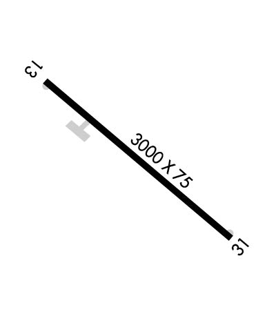
| Lat: N 3049.2 Long: W 09006.8 Elev: 175 Var: -03 Longest Runway: 3000 | ||
| CTAF: 122.9 | ||
| ||||||||||||||||||||||||||||||||
| ||||||||||||||||||||||||||||||||
| Rwy | Rwy | |||||||
| 3000x75 | 3000' | 3000x75 | 3000' | |||||
| Runway ID | Single Wheel | Double Wheel | Double Tandem Wheel | Dual Double Wheel |
| 13/31 | 20,000 | N/A | N/A | N/A |
| These numbers are Advisory and are not limits. The Airport Manager should have more accurate Weight Limits | ||||
| FltPlan does not have IFR approach charts available for K2R7. |
 Airport Diagram might not be current. | |
| Facility Name: | FRANKLINTON |
| City Name: | FRANKLINTON |
| County: | WASHINGTON |
| State abbrev: | LA |
| State Name: | LOUISIANA |
| Ownership: | PUBLICLY OWNED |
| Use: | OPEN TO THE PUBLIC |
| Owner's Name: | TOWN OF FRANKLINTON |
| Address: | 301 11TH AVE |
| FRANKLINTON, LA 70438 | |
| Owner's Phone: | 985-839-3569 |
| Manager's Name: | MARTY ROBERTS |
| Address: | 26469 OLD LAKE ROAD |
| MOUNT HERMON, LA 70450 | |
| Phone: | (225) 333-1579 |
| FAA Region: | SOUTHWEST |
| FAA Field Office: | LNM |
| Date | Sunrise | Sunset |
|---|---|---|
| 09/24/21 Friday | 6:50 | 18:55 |
| 09/25/21 Saturday | 6:50 | 18:53 |
| 09/26/21 Sunday | 6:51 | 18:52 |
| 09/27/21 Monday | 6:51 | 18:51 |
| 09/28/21 Tuesday | 6:52 | 18:50 |
| 09/29/21 Wednesday | 6:53 | 18:48 |
| 09/30/21 Thursday | 6:53 | 18:47 |
| 10/01/21 Friday | 6:54 | 18:46 |
| 10/02/21 Saturday | 6:54 | 18:45 |
| 10/03/21 Sunday | 6:55 | 18:43 |
| 10/04/21 Monday | 6:56 | 18:42 |
| 10/05/21 Tuesday | 6:56 | 18:41 |
| 10/06/21 Wednesday | 6:57 | 18:40 |
| 10/07/21 Thursday | 6:58 | 18:39 |
| Airport Attendance Schedule | UNATTENDED |
| Airport Status | OPERATIONAL (This Status can change at any time - please check NOTAMS) |
| Airport Lighting Schedule | MIRL RWY 13/31 PRESET LOW INTST; TO INCR INTST ACTVT - CTAF. |
| Airport Storage Available | Tie Downs, Hanger |
| Extra Services Available | NONE |
| Wind Indicator | YES - (lighted) |
| Control Tower | NO |
| CTAF Frequency | 122.900 |
| Unicom Frequency | |
| Rotating Beacon Color | CLEAR-GREEN (Light Land Airport) |
| Segmented Circle | NO |
| Landing Fee | NO |
| Airport Inspected | STATE - performed by STATE AERONAUTICAL PERSONNEL |
| Inspection Date | 09/03/2020 |
| Type of Fuel Available | None |
| Airframe Repair Service | None |
| Power Plant Repair Service | None |
| Latitude | N3049.2 |
| Longitude | W09006.8 (ESTIMATED) |
| Arpt Elevation | 175ft (ESTIMATED) |
| Magnetic Variation | 03E |
| 3 miles SE | of FRANKLINTON |
| Traffic Pattern Altitude | |
| Sectional Chart | NEW ORLEANS |
| Operations (Reported) | Yearly | Avg. Daily |
|---|---|---|
| General Aviation Transient | 5500 | 15 |
| General Aviation Local | 8500 | 23 |
| Air Taxi | 0 | 0 |
| Commerical | 0 | 0 |
| Commuter | 0 | 0 |
| Military | 0 | 0 |
| Aircraft based on Field | |
|---|---|
| General Aviation Singles | 7 |
| General Aviation Multi | 0 |
| Jet Aircraft | 0 |
| General Aviation Helicopters | 0 |
| Military Aircraft | 0 |
| Gliders | 0 |
| Ultralights | 0 |
| FSS on field | NO |
| FSS tie-in | DE RIDDER |
| FSS Phone | 1-800-WX-BRIEF |
| Who issues Notams | DRI |
| Notam D service at airport | YES |
| ARTCC Name | HOUSTON |
| Airport Certification | |
| Aircraft Rescue & Firefighting Index | None |
| Airport of Entry | No |
| Custom Landing Rights | No |
| Joint Civil/Military | No |
| Military Landing rights | No |
| GOLF COURSE .25 MILES NORTH OF AIRPORT. |
| FOR CD CTC HOUSTON ARTCC AT 281-230-5622. |
| ARPT LGTG OTS. VFR ONLY |
| Runway: 13 | Runway: 31 | ||
| Mag heading: | 128° | Mag heading: | 308° |
| Rwy Slope: | .07% Up | Rwy Slope: | -.07% Down |
| Approach: | Approach: | ||
| Pattern: | Left Traffic | Pattern: | Left Traffic |
| Markings: | NONPRECISION INSTRUMENT | Markings: | NONPRECISION INSTRUMENT |
| Marking Condition: | FAIR | Marking Condition: | FAIR |
| Arresting Dev: | Arresting Dev: | ||
| Lat & Long: | N3049.3 W09007.0 | Lat. & Long.: | N3049.0 W09006.5 |
| Elev: | 172.0 ft. MSL | Elev: | 174.0 ft. MSL |
| TCH: | 50 ft. AGL | TCH: | 50 ft. AGL |
| Visual Glide Path: | 3.00 degrees | Visual Glide Path: | 3.00 degrees |
| Displaced Threshold: | No | Displaced Threshold: | No |
| Touchdown Zone: | NO | Touchdown Zone: | NO |
| Touchdown Elev.: | Touchdown Elev.: | ||
| Visual Glide Slope: | 2-Light PAPI on LEFT side of Runway; RY 13 PAPI OTS INDEFLY. | Visual Glide Slope: | 2-Light PAPI on LEFT side of Runway; RY 31 PAPI OTS INDEFLY. |
| RVR Equipment: | RVR Equipment: | ||
| RVV Equipment: | NO | RVV Equipment: | NO |
| Approach Lights: | Approach Lights: | ||
| REIL: | YES; RWY 13 LEFT SIDE REIL LIGHT OTS. | REIL: | YES; RWY 31 REILS OTS. |
| Centerline Lights: | NO | Centerline Lights: | NO |
| Touchdown lights: | NO | Touchdown lights: | NO |
| Runway Category: | Runway with a Visual Approach | Runway Category: | Runway with a Visual Approach |
| Declared Distances: | Declared Distances: | ||
| Obstructions: | TREES | Obstructions: | TREES |
| Marked: | NOT Marked/Lighted | Marked: | NOT Marked/Lighted |
| Clearance slope: | 11:1 | Clearance slope: | 9:1 |
| Obstruction height: | 76 feet AGL | Obstruction height: | 73 feet AGL |
| Dist. from runway: | 1069 feet | Dist. from runway: | 901 feet |
| Centerline offset: | 185 right of centerline | Centerline offset: | 171 feet right of centerline |
| Comments: | Comments: |
Thanks for using FltPlan.com
all rights reserved © 1999-2021 by Flight Plan LLC
