| PETER PRINCE FIELD MILTON FL |
| |
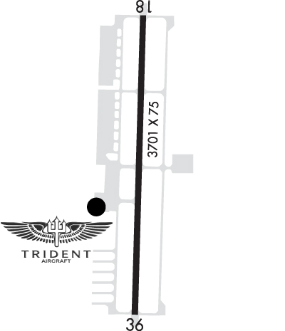
| Lat: N 3038.3 Long: W 08659.6 Elev: 82 Var: +01 Longest Runway: 3701 | ||
| CTAF: 122.97 | ||
| |||||||||||||||||||||||||||||||||||||||
| |||||||||||||||||||||||||||||||||||||||
| |||||||||||||||||||||||||||||||||||||||
| Rwy | Rwy | |||||||
| 3701x75 | 3701' | 3701x75 | 3701' | |||||
| Runway ID | Single Wheel | Double Wheel | Double Tandem Wheel | Dual Double Wheel |
| 18/36 | 22,000 | N/A | N/A | N/A |
| These numbers are Advisory and are not limits. The Airport Manager should have more accurate Weight Limits | ||||
 Airport Diagram might not be current. | |
| Facility Name: | PETER PRINCE FLD |
| City Name: | MILTON |
| County: | SANTA ROSA |
| State abbrev: | FL |
| State Name: | FLORIDA |
| Ownership: | PUBLICLY OWNED |
| Use: | OPEN TO THE PUBLIC |
| Owner's Name: | SANTA ROSA COUNTY; CTC PERSON: TINA STEWART 850-981-2071. |
| Address: | 6495 CAROLINE STREET |
| MILTON, FL 32570 | |
| Owner's Phone: | 850-983-1855 |
| Manager's Name: | TINA STEWART; AIRPORT PHYSICAL ADDRESS: 5550 NORTH AIRPORT RD. |
| Address: | 6491 CAROLINE ST, SUITE 4 |
| MILTON, FL 32570 | |
| Phone: | 850-623-0174 |
| FAA Region: | SOUTHERN |
| FAA Field Office: | ORL |
| Date | Sunrise | Sunset |
|---|---|---|
| 09/24/21 Friday | 6:37 | 18:42 |
| 09/25/21 Saturday | 6:38 | 18:41 |
| 09/26/21 Sunday | 6:38 | 18:40 |
| 09/27/21 Monday | 6:39 | 18:38 |
| 09/28/21 Tuesday | 6:40 | 18:37 |
| 09/29/21 Wednesday | 6:40 | 18:36 |
| 09/30/21 Thursday | 6:41 | 18:35 |
| 10/01/21 Friday | 6:41 | 18:33 |
| 10/02/21 Saturday | 6:42 | 18:32 |
| 10/03/21 Sunday | 6:43 | 18:31 |
| 10/04/21 Monday | 6:43 | 18:30 |
| 10/05/21 Tuesday | 6:44 | 18:29 |
| 10/06/21 Wednesday | 6:44 | 18:27 |
| 10/07/21 Thursday | 6:45 | 18:26 |
| Airport Attendance Schedule | 7 Days A Week 0700-DUSK |
| Airport Status | OPERATIONAL (This Status can change at any time - please check NOTAMS) |
| Airport Lighting Schedule | ACTVT PAPI 18 & 36; MIRL RWY 18/36 - CTAF. |
| Airport Storage Available | Tie Downs |
| Extra Services Available | NONE |
| Wind Indicator | YES - (lighted) |
| Control Tower | NO |
| CTAF Frequency | 122.975 |
| Unicom Frequency | 122.975; AUTOMATED UNICOM |
| Rotating Beacon Color | CLEAR-GREEN (Light Land Airport) |
| Segmented Circle | YES |
| Landing Fee | NO |
| Airport Inspected | STATE - performed by STATE AERONAUTICAL PERSONNEL |
| Inspection Date | 03/07/2018 |
| Type of Fuel Available | Grade 100LL, JET A-1 (icing inhibitor, freeze point -50C); -10FUEL 24 HR CREDIT CARD SVC AVBL. |
| Airframe Repair Service | MAJOR |
| Power Plant Repair Service | MAJOR |
| Latitude | N3038.3 |
| Longitude | W08659.6 (ESTIMATED) |
| Arpt Elevation | 81ft (SURVEYED) |
| Magnetic Variation | 01W |
| 3 miles E | of MILTON |
| Traffic Pattern Altitude | |
| Sectional Chart | NEW ORLEANS |
| Operations (Reported) | Yearly | Avg. Daily |
|---|---|---|
| General Aviation Transient | 7500 | 21 |
| General Aviation Local | 86400 | 237 |
| Air Taxi | 0 | 0 |
| Commerical | 0 | 0 |
| Commuter | 0 | 0 |
| Military | 50 | 0 |
| Aircraft based on Field | |
|---|---|
| General Aviation Singles | 108 |
| General Aviation Multi | 17 |
| Jet Aircraft | 0 |
| General Aviation Helicopters | 4 |
| Military Aircraft | 0 |
| Gliders | 0 |
| Ultralights | 4 |
| FSS on field | NO |
| FSS tie-in | GAINESVILLE |
| FSS Phone | 1-800-WX-BRIEF |
| Who issues Notams | GNV |
| Notam D service at airport | YES |
| ARTCC Name | JACKSONVILLE |
| Airport Certification | |
| Aircraft Rescue & Firefighting Index | None |
| Airport of Entry | No |
| Custom Landing Rights | No |
| Joint Civil/Military | No |
| Military Landing rights | YES |
| NATIONAL PLAN OF INTEGRATED AIRPORT SYSTEMS (NPIAS) |
| GRANT AGREEMENTS UNDER FAAP/ADAP/AIP |
| ASSURANCES PURSUANT TO TITLE VI, CIVIL RIGHTS ACT OF 1964 |
| BE ALERT ARPT SITUATED IN CUT-OFF OF NAS WHITING CASS C AIRSPACE LOCATED 1400 FT OVERHEAD WITHIN 1 MILE FROM THE CENTER OF THE ARPT ON THREE SIDES TO THE EAST, NORTH, AND WEST FROM SURFACE TO 4200 FT. |
| GCO AVBL ON FREQ 121.725 THRU PENSACOLA APCH. |
| INTENSIVE FLIGHT TRAINING INVOF ARPT. |
| LIMITED PARKING ON WEST RAMP FOR TRANSIENT ACFT URGED TO BRING TIE-DOWN ROPES FOR EAST RAMP PARKING. |
| FOR CD IF UNA VIA GCO CTC JACKSONVILLE ARTCC AT 904-845-1592. |
Airport Communications & Frequencies:
| ||||||||||||||
| Runway: 18 | Runway: 36 | ||
| Mag heading: | 183° | Mag heading: | 3° |
| Rwy Slope: | .02% Up | Rwy Slope: | -.02% Down |
| Approach: | Approach: | ||
| Pattern: | Right Traffic | Pattern: | Left Traffic |
| Markings: | BASIC | Markings: | NONPRECISION INSTRUMENT |
| Marking Condition: | FAIR | Marking Condition: | FAIR |
| Arresting Dev: | Arresting Dev: | ||
| Lat & Long: | N3038.6 W08659.6 | Lat. & Long.: | N3038.0 W08659.6 |
| Elev: | 78.6 ft. MSL | Elev: | 79.2 ft. MSL |
| TCH: | 58 ft. AGL | TCH: | 72 ft. AGL |
| Visual Glide Path: | 3.10 degrees | Visual Glide Path: | 4.05 degrees |
| Displaced Threshold: | No | Displaced Threshold: | No |
| Touchdown Zone: | YES | Touchdown Zone: | YES |
| Touchdown Elev.: | 81.6 feet | Touchdown Elev.: | 81.6 feet |
| Visual Glide Slope: | 2-Light PAPI on LEFT side of Runway | Visual Glide Slope: | 2-Light PAPI on LEFT side of Runway |
| RVR Equipment: | RVR Equipment: | ||
| RVV Equipment: | NO | RVV Equipment: | NO |
| Approach Lights: | Approach Lights: | ||
| REIL: | YES | REIL: | YES |
| Centerline Lights: | NO | Centerline Lights: | NO |
| Touchdown lights: | NO | Touchdown lights: | NO |
| Runway Category: | Runway with a Visual Approach | Runway Category: | Runway with a Non-precision Approach |
| Declared Distances: | Declared Distances: | ||
| Obstructions: | BRUSH | Obstructions: | TREES |
| Marked: | NOT Marked/Lighted | Marked: | NOT Marked/Lighted |
| Clearance slope: | 1:1 | Clearance slope: | 15:1 |
| Obstruction height: | 4 feet AGL | Obstruction height: | 44 feet AGL |
| Dist. from runway: | 50 feet | Dist. from runway: | 880 feet |
| Centerline offset: | 98 left of centerline | Centerline offset: | 225 feet right of centerline |
| Comments: | RWY 18 HAS 4 FT BRUSH 50 FT FROM RWY END 98 FT LEFT. | Comments: |
Thanks for using FltPlan.com
all rights reserved © 1999-2021 by Flight Plan LLC