
| HENDRICKS COUNTY-GORDON GRAHAM INDIANAPOLIS IN |
| |
| Lat: N 3944.8 Long: W 08628.5 Elev: 898 Var: +03 Longest Runway: 4400 | ||
| AWOS: 118.02 CTAF: 122.7 | ||
| ||||||
| ||||||
|
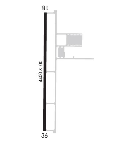
| Rwy | Rwy | |||||||
| 4400x100 | 4400' | 4400x100 | 4400' | |||||
| Runway ID | Single Wheel | Double Wheel | Double Tandem Wheel | Dual Double Wheel |
| 18/36 | N/A | N/A | N/A | N/A |
| These numbers are Advisory and are not limits. The Airport Manager should have more accurate Weight Limits | ||||
 Airport Diagram might not be current. | |
| Facility Name: | HENDRICKS COUNTY-GORDON GRAHAM FLD |
| City Name: | INDIANAPOLIS |
| County: | HENDRICKS |
| State abbrev: | IN |
| State Name: | INDIANA |
| Ownership: | PUBLICLY OWNED |
| Use: | OPEN TO THE PUBLIC |
| Owner's Name: | INDIANAPOLIS AIRPORT AUTHORITY |
| Address: | 7800 COL. H. WEIR COOK MEMORIAL DR., SUITE 100 |
| INDIANAPOLIS, IN 46241 | |
| Owner's Phone: | (317) 487-5022 |
| Manager's Name: | KEITH BERLEN |
| Address: | 7800 COL. H. WEIR COOK MEMORIAL DR., SUITE 100 |
| INDIANAPOLIS, IN 46241 | |
| Phone: | (317) 487-5022 |
| FAA Region: | GREAT LAKES |
| FAA Field Office: | CHI |
| Date | Sunrise | Sunset |
|---|---|---|
| 09/24/21 Friday | 7:35 | 19:40 |
| 09/25/21 Saturday | 7:36 | 19:38 |
| 09/26/21 Sunday | 7:37 | 19:37 |
| 09/27/21 Monday | 7:38 | 19:35 |
| 09/28/21 Tuesday | 7:39 | 19:34 |
| 09/29/21 Wednesday | 7:40 | 19:32 |
| 09/30/21 Thursday | 7:41 | 19:30 |
| 10/01/21 Friday | 7:42 | 19:29 |
| 10/02/21 Saturday | 7:43 | 19:27 |
| 10/03/21 Sunday | 7:44 | 19:25 |
| 10/04/21 Monday | 7:45 | 19:24 |
| 10/05/21 Tuesday | 7:46 | 19:22 |
| 10/06/21 Wednesday | 7:47 | 19:21 |
| 10/07/21 Thursday | 7:48 | 19:19 |
| Airport Attendance Schedule | MON-FRI 0700-1530 |
| Airport Status | OPERATIONAL (This Status can change at any time - please check NOTAMS) |
| Airport Lighting Schedule | ACTVT REIL RWY 18 & 36; MIRL RWY 18/36 - CTAF. MIRL RWY 18/36 PRESET TO LOW INTST, TO INCR INTST - CTAF. |
| Airport Storage Available | Tie Downs, Hanger |
| Extra Services Available | Flight Instruction, Aircraft Rental |
| Wind Indicator | YES - (lighted) |
| Control Tower | NO |
| CTAF Frequency | 122.700 |
| Unicom Frequency | 122.700 |
| Rotating Beacon Color | CLEAR-GREEN (Light Land Airport) |
| Segmented Circle | YES |
| Landing Fee |
| Airport Inspected | STATE - performed by STATE AERONAUTICAL PERSONNEL |
| Inspection Date | 04/23/2020 |
| Type of Fuel Available | Grade 100LLMOGAS |
| Airframe Repair Service | None |
| Power Plant Repair Service | None |
| Latitude | N3944.8 |
| Longitude | W08628.5 (ESTIMATED) |
| Arpt Elevation | 897ft (SURVEYED) |
| Magnetic Variation | 03W |
| 13 miles W | of INDIANAPOLIS |
| Traffic Pattern Altitude | |
| Sectional Chart | ST LOUIS |
| Operations (Reported) | Yearly | Avg. Daily |
|---|---|---|
| General Aviation Transient | 5869 | 16 |
| General Aviation Local | 6747 | 18 |
| Air Taxi | 269 | 1 |
| Commerical | 0 | 0 |
| Commuter | 0 | 0 |
| Military | 546 | 1 |
| Aircraft based on Field | |
|---|---|
| General Aviation Singles | 48 |
| General Aviation Multi | 3 |
| Jet Aircraft | 0 |
| General Aviation Helicopters | 0 |
| Military Aircraft | 0 |
| Gliders | 0 |
| Ultralights | 0 |
| FSS on field | NO |
| FSS tie-in | TERRE HAUTE |
| FSS Phone | 1-800-WX-BRIEF |
| Who issues Notams | HUF |
| Notam D service at airport | YES |
| ARTCC Name | INDIANAPOLIS |
| Airport Certification | |
| Aircraft Rescue & Firefighting Index | None |
| Airport of Entry | No |
| Custom Landing Rights | No |
| Joint Civil/Military | No |
| Military Landing rights | No |
| NATIONAL PLAN OF INTEGRATED AIRPORT SYSTEMS (NPIAS) |
| USE CAUTION FOR RC MODEL AIRCRAFT ACTIVITY LOCATED APPROXIMATELY 1 NM WEST OF THE RWY 18 THRESHOLD OPERATING BLO 400 FT AGL. |
| FOR CD CTC INDIANAPOLIS APCH AT 317-227-5743. |
Airport Communications & Frequencies:
|
| Runway: 18 | Runway: 36 | ||
| Mag heading: | 183° | Mag heading: | 3° |
| Rwy Slope: | -.76% Down | Rwy Slope: | .76% Up |
| Approach: | Approach: | ||
| Pattern: | Left Traffic | Pattern: | Left Traffic |
| Markings: | NONPRECISION INSTRUMENT | Markings: | NONPRECISION INSTRUMENT |
| Marking Condition: | GOOD | Marking Condition: | GOOD |
| Arresting Dev: | Arresting Dev: | ||
| Lat & Long: | N3945.2 W08628.5 | Lat. & Long.: | N3944.4 W08628.5 |
| Elev: | 897.8 ft. MSL | Elev: | 864.3 ft. MSL |
| TCH: | 44 ft. AGL | TCH: | 43 ft. AGL |
| Visual Glide Path: | 3.00 degrees | Visual Glide Path: | 3.00 degrees |
| Displaced Threshold: | No | Displaced Threshold: | No |
| Touchdown Zone: | YES | Touchdown Zone: | YES |
| Touchdown Elev.: | 897.8 feet | Touchdown Elev.: | 884.4 feet |
| Visual Glide Slope: | 2-Light PAPI on LEFT side of Runway | Visual Glide Slope: | 2-Light PAPI on LEFT side of Runway |
| RVR Equipment: | RVR Equipment: | ||
| RVV Equipment: | NO | RVV Equipment: | NO |
| Approach Lights: | Approach Lights: | ||
| REIL: | YES | REIL: | YES |
| Centerline Lights: | NO | Centerline Lights: | NO |
| Touchdown lights: | NO | Touchdown lights: | NO |
| Runway Category: | Runway with a Non-precision Approach | Runway Category: | Runway with a Non-precision Approach |
| Declared Distances: | Declared Distances: | ||
| Obstructions: | Obstructions: | PLINE | |
| Marked: | Marked: | LIGHTED | |
| Clearance slope: | 34:1 | Clearance slope: | 21:1 |
| Obstruction height: | Obstruction height: | 25 feet AGL | |
| Dist. from runway: | Dist. from runway: | 726 feet | |
| Centerline offset: | Centerline offset: | 230 feet left of centerline | |
| Comments: | Comments: |
Thanks for using FltPlan.com
all rights reserved © 1999-2021 by Flight Plan LLC
