
| LE MAIRE MEMORIAL JEANERETTE LA |
| |
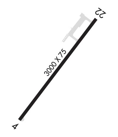
| Lat: N 2953.9 Long: W 09140.0 Elev: 14 Var: -04 Longest Runway: 3000 | ||
| CTAF: 122.9 | ||
| ||||||||||||||||||||||||||||||||||||||||||||
| ||||||||||||||||||||||||||||||||||||||||||||
| Rwy | Rwy | |||||||
| 3000x75 | 3000' | 3000x75 | 2397' | |||||
| Runway ID | Single Wheel | Double Wheel | Double Tandem Wheel | Dual Double Wheel |
| 04/22 | 6,000 | N/A | N/A | N/A |
| These numbers are Advisory and are not limits. The Airport Manager should have more accurate Weight Limits | ||||
| FltPlan does not have IFR approach charts available for K2R1. |
 Airport Diagram might not be current. | |
| Facility Name: | LE MAIRE MEML |
| City Name: | JEANERETTE |
| County: | IBERIA |
| State abbrev: | LA |
| State Name: | LOUISIANA |
| Ownership: | PUBLICLY OWNED |
| Use: | OPEN TO THE PUBLIC |
| Owner's Name: | IBERIA PARISH AIRPORT AUTHORITY |
| Address: | 1404 HANGAR DR. |
| NEW IBERIA, LA 70560 | |
| Owner's Phone: | 337-365-7202 |
| Manager's Name: | MAURICE SONGY |
| Address: | 1404 HANGAR DR. |
| NEW IBERIA, LA 70560 | |
| Phone: | 337-365-7202 |
| FAA Region: | SOUTHWEST |
| FAA Field Office: | LNM |

| Date | Sunrise | Sunset |
|---|---|---|
| 06/07/26 Sunday | 6:05 | 20:06 |
| 06/08/26 Monday | 6:05 | 20:06 |
| 06/09/26 Tuesday | 6:05 | 20:07 |
| 06/10/26 Wednesday | 6:05 | 20:07 |
| 06/11/26 Thursday | 6:05 | 20:07 |
| 06/12/26 Friday | 6:05 | 20:08 |
| 06/13/26 Saturday | 6:05 | 20:08 |
| 06/14/26 Sunday | 6:05 | 20:09 |
| 06/15/26 Monday | 6:05 | 20:09 |
| 06/16/26 Tuesday | 6:05 | 20:09 |
| 06/17/26 Wednesday | 6:06 | 20:10 |
| 06/18/26 Thursday | 6:06 | 20:10 |
| 06/19/26 Friday | 6:06 | 20:10 |
| 06/20/26 Saturday | 6:06 | 20:10 |
| Airport Attendance Schedule | UNATTENDED; FOR ARPT ATTENDANT CALL 337-365-7202. |
| Airport Status | OPERATIONAL (This Status can change at any time - please check NOTAMS) |
| Airport Lighting Schedule | SS-SR. MIRL RY 04/22 & REIL RYS 04 & 22 PRESET LOW INTST SS-SR; TO INCR INTST ACTVT -122.90. |
| Airport Storage Available | Tie Downs, Hanger |
| Extra Services Available | Crop Dusting |
| Wind Indicator | YES - (lighted) |
| Control Tower | NO |
| CTAF Frequency | 122.900 |
| Unicom Frequency | |
| Rotating Beacon Color | WG |
| Segmented Circle | NO |
| Landing Fee | NO |
| Airport Inspected | STATE - performed by STATE AERONAUTICAL PERSONNEL |
| Inspection Date | 05/31/2022 |
| Type of Fuel Available | Grade 100LL; -10FUEL AVBL 24 HRS SELF SERVICE WITH CREDIT CARD. |
| Airframe Repair Service | NONE |
| Power Plant Repair Service | NONE |
| Latitude | N2953.9 |
| Longitude | W09140.0 (ESTIMATED) |
| Arpt Elevation | 14ft (ESTIMATED) |
| Magnetic Variation | 04E |
| 1 miles S | of JEANERETTE |
| Traffic Pattern Altitude | |
| Sectional Chart | HOUSTON |
| Operations (Reported) | Yearly | Avg. Daily |
|---|---|---|
| General Aviation Transient | 0 | 0 |
| General Aviation Local | 0 | 0 |
| Air Taxi | 0 | 0 |
| Commerical | 0 | 0 |
| Commuter | 0 | 0 |
| Military | 0 | 0 |
| Aircraft based on Field | |
|---|---|
| General Aviation Singles | 0 |
| General Aviation Multi | 0 |
| Jet Aircraft | 0 |
| General Aviation Helicopters | 0 |
| Military Aircraft | 0 |
| Gliders | 0 |
| Ultralights | 0 |
| FSS on field | NO |
| FSS tie-in | DE RIDDER |
| FSS Phone | 1-800-WX-BRIEF |
| Who issues Notams | DRI |
| Notam D service at airport | YES |
| ARTCC Name | HOUSTON |
| Airport Certification | |
| Aircraft Rescue & Firefighting Index | None |
| Airport of Entry | No |
| Custom Landing Rights | No |
| Joint Civil/Military | No |
| Military Landing rights | No |
| GRANT AGREEMENT HAS EXPIRED; HOWEVER, AGREEMENT REMAINS IN EFFECT FOR THIS FACILITY AS LONG AS IT IS PUBLIC USE. |
| FOR CD CTC LAFAYETTE APCH AT 337-262-2729, WHEN APCH CLSD CTC HOUSTON ARTCC AT 281-230-5622. |
| CTC APRT MGR FOR DSGND RAMP SPACE FOR PUB USE. |
| RWY 04/2 2 PAVEMENT ROUGHNESS, MDT TO SEV LONGITUDINAL CRACKING, RAVELING PRODUCING FOD APPROXIMATELY 1000 FT FM EOR 22. |
| Runway: 04 | Runway: 22 | ||
| Mag heading: | 33° | Mag heading: | 213° |
| Approach: | Approach: | ||
| Pattern: | Left Traffic | Pattern: | Left Traffic |
| Markings: | NONPRECISION INSTRUMENT | Markings: | NONPRECISION INSTRUMENT |
| Marking Condition: | FAIR | Marking Condition: | FAIR |
| Arresting Dev: | Arresting Dev: | ||
| Lat & Long: | N2953.7 W09140.1 | Lat. & Long.: | N2954.1 W09139.8 |
| Elev: | N/A | Elev: | N/A |
| TCH: | 75 ft. AGL | TCH: | 63 ft. AGL |
| Visual Glide Path: | 4.50 degrees | Visual Glide Path: | 3.75 degrees |
| Displaced Threshold: | No | Displaced Threshold: | 603 feet |
| Touchdown Zone: | NO | Touchdown Zone: | NO |
| Touchdown Elev.: | Touchdown Elev.: | ||
| Visual Glide Slope: | 2-Light PAPI on LEFT side of Runway | Visual Glide Slope: | 2-Light PAPI on LEFT side of Runway |
| RVR Equipment: | RVR Equipment: | ||
| RVV Equipment: | NO | RVV Equipment: | NO |
| Approach Lights: | Approach Lights: | ||
| REIL: | YES | REIL: | YES |
| Centerline Lights: | NO | Centerline Lights: | NO |
| Touchdown lights: | NO | Touchdown lights: | NO |
| Runway Category: | Runway with a Visual Approach | Runway Category: | Runway with a Visual Approach |
| Declared Distances: | Declared Distances: | ||
| Obstructions: | TREES | Obstructions: | TREES |
| Marked: | NOT Marked/Lighted | Marked: | NOT Marked/Lighted |
| Clearance slope: | 7:1 | Clearance slope: | 5:1; APCH SLOPE 17:1 TO DSPLCD THLD. |
| Obstruction height: | 21 feet AGL | Obstruction height: | 68 feet AGL |
| Dist. from runway: | 352 feet | Dist. from runway: | 607 feet |
| Centerline offset: | Centerline offset: | 109 feet left of centerline | |
| Comments: | Comments: |
Thanks for using FltPlan.com
all rights reserved © 1999-2026 by Flight Plan LLC