
| ANGWIN-PARRETT FIELD ANGWIN CA |
| |
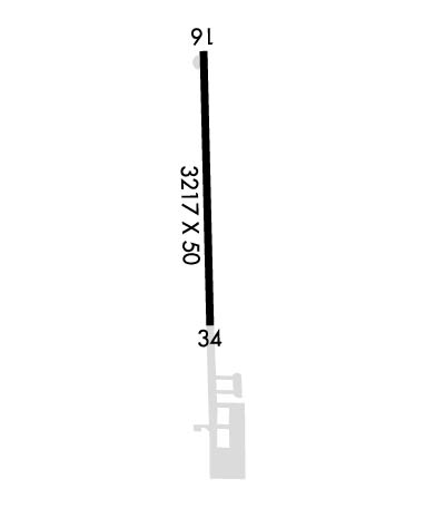
| Lat: N 3834.8 Long: W 12226.1 Elev: 1875 Var: -16 Longest Runway: 3217 | ||
| CTAF: 123.0 | ||
| ||||||||||||||||||||||||||||||||||||||||||||
| ||||||||||||||||||||||||||||||||||||||||||||
| Rwy | Rwy | |||||||
| 3217x50 | 3217' | 3217x50 | 3217' | |||||
| Runway ID | Single Wheel | Double Wheel | Double Tandem Wheel | Dual Double Wheel |
| 16/34 | N/A | N/A | N/A | N/A |
| These numbers are Advisory and are not limits. The Airport Manager should have more accurate Weight Limits | ||||
| FltPlan does not have IFR approach charts available for K2O3. |
 Airport Diagram might not be current. | |
| Facility Name: | ANGWIN-PARRETT FLD |
| City Name: | ANGWIN |
| County: | NAPA |
| State abbrev: | CA |
| State Name: | CALIFORNIA |
| Ownership: | PRIVATELY OWNED |
| Use: | OPEN TO THE PUBLIC |
| Owner's Name: | PACIFIC UNION COLLEGE |
| Address: | 1 ANGWIN AVENUE |
| ANGWIN, CA 94508 | |
| Owner's Phone: | 707-965-6219 |
| Manager's Name: | KEUNSANG CHO |
| Address: | 1 ANGWIN AVENUE |
| ANGWIN, CA 94508 | |
| Phone: | 707-965-6219 |
| FAA Region: | WESTERN-PACIFIC |
| FAA Field Office: | SFO |
| Date | Sunrise | Sunset |
|---|---|---|
| 09/24/21 Friday | 6:59 | 19:04 |
| 09/25/21 Saturday | 7:00 | 19:02 |
| 09/26/21 Sunday | 7:01 | 19:01 |
| 09/27/21 Monday | 7:02 | 18:59 |
| 09/28/21 Tuesday | 7:03 | 18:57 |
| 09/29/21 Wednesday | 7:04 | 18:56 |
| 09/30/21 Thursday | 7:05 | 18:54 |
| 10/01/21 Friday | 7:05 | 18:53 |
| 10/02/21 Saturday | 7:06 | 18:51 |
| 10/03/21 Sunday | 7:07 | 18:50 |
| 10/04/21 Monday | 7:08 | 18:48 |
| 10/05/21 Tuesday | 7:09 | 18:47 |
| 10/06/21 Wednesday | 7:10 | 18:45 |
| 10/07/21 Thursday | 7:11 | 18:44 |
| Airport Attendance Schedule | SUN-FRI 0800-1700 |
| Airport Status | OPERATIONAL (This Status can change at any time - please check NOTAMS) |
| Airport Lighting Schedule | ACTVT LIRL RY 16/34 AND TRVC RYS 16 & 34 - CTAF. |
| Airport Storage Available | Tie Downs |
| Extra Services Available | Flight Instruction, Aircraft Rental |
| Wind Indicator | YES - (lighted) |
| Control Tower | NO |
| CTAF Frequency | 123.000 |
| Unicom Frequency | 123.000 |
| Rotating Beacon Color | |
| Segmented Circle | YES |
| Landing Fee | NO |
| Airport Inspected | STATE - performed by STATE AERONAUTICAL PERSONNEL |
| Inspection Date | 01/30/2020 |
| Type of Fuel Available | Grade 100LL |
| Airframe Repair Service | MAJOR |
| Power Plant Repair Service | MAJOR |
| Latitude | N3834.8 |
| Longitude | W12226.1 (ESTIMATED) |
| Arpt Elevation | 1875ft (ESTIMATED) |
| Magnetic Variation | 16E |
| 1 miles E | of ANGWIN |
| Traffic Pattern Altitude | 850 |
| Sectional Chart | SAN FRANCISCO |
| Operations (Reported) | Yearly | Avg. Daily |
|---|---|---|
| General Aviation Transient | 2000 | 5 |
| General Aviation Local | 8000 | 22 |
| Air Taxi | 0 | 0 |
| Commerical | 0 | 0 |
| Commuter | 0 | 0 |
| Military | 0 | 0 |
| Aircraft based on Field | |
|---|---|
| General Aviation Singles | 38 |
| General Aviation Multi | 4 |
| Jet Aircraft | 0 |
| General Aviation Helicopters | 0 |
| Military Aircraft | 0 |
| Gliders | 0 |
| Ultralights | 2 |
| FSS on field | NO |
| FSS tie-in | OAKLAND |
| FSS Phone | 1-800-WX-BRIEF |
| Who issues Notams | OAK |
| Notam D service at airport | YES |
| ARTCC Name | OAKLAND |
| Airport Certification | |
| Aircraft Rescue & Firefighting Index | None |
| Airport of Entry | No |
| Custom Landing Rights | No |
| Joint Civil/Military | No |
| Military Landing rights | No |
| FOR CD CTC OAKLAND ARTCC AT 510-745-3380. |
| Runway: 16 | Runway: 34 | ||
| Mag heading: | N/A | Mag heading: | N/A |
| Rwy Slope: | -1.06% Down | Rwy Slope: | 1.06% Up |
| Approach: | Approach: | ||
| Pattern: | Left Traffic | Pattern: | Right Traffic |
| Markings: | BASIC | Markings: | BASIC |
| Marking Condition: | GOOD | Marking Condition: | GOOD |
| Arresting Dev: | Arresting Dev: | ||
| Lat & Long: | N3835.1 W12226.2 | Lat. & Long.: | N3834.5 W12226.1 |
| Elev: | 1875.0 ft. MSL | Elev: | 1841.0 ft. MSL |
| TCH: | 18 ft. AGL | TCH: | 18 ft. AGL |
| Visual Glide Path: | 5.00 degrees | Visual Glide Path: | 5.00 degrees |
| Displaced Threshold: | No | Displaced Threshold: | No |
| Touchdown Zone: | NO | Touchdown Zone: | NO |
| Touchdown Elev.: | Touchdown Elev.: | ||
| Visual Glide Slope: | TRI-COLOR VASI ON LEFT SIDE OF RUNWAY | Visual Glide Slope: | TRI-COLOR VASI ON RIGHT SIDE OF RUNWAY |
| RVR Equipment: | RVR Equipment: | ||
| RVV Equipment: | NO | RVV Equipment: | NO |
| Approach Lights: | Approach Lights: | ||
| REIL: | NO | REIL: | NO |
| Centerline Lights: | NO | Centerline Lights: | NO |
| Touchdown lights: | NO | Touchdown lights: | NO |
| Runway Category: | Runway with a Visual Approach | Runway Category: | Runway with a Visual Approach |
| Declared Distances: | Declared Distances: | ||
| Obstructions: | TREE | Obstructions: | TREES |
| Marked: | NOT Marked/Lighted | Marked: | NOT Marked/Lighted |
| Clearance slope: | 16:1 | Clearance slope: | 19:1 |
| Obstruction height: | 50 feet AGL | Obstruction height: | 100 feet AGL |
| Dist. from runway: | 1000 feet | Dist. from runway: | 2100 feet |
| Centerline offset: | 210 left of centerline | Centerline offset: | 330 feet right of centerline |
| Comments: | Comments: |
Thanks for using FltPlan.com
all rights reserved © 1999-2021 by Flight Plan LLC
