| GANSNER FIELD QUINCY CA |
| |
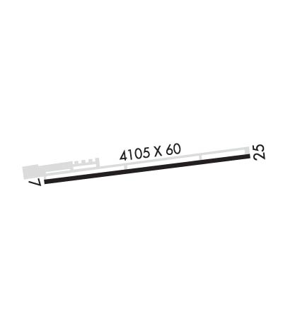
| Lat: N 3956.6 Long: W 12056.7 Elev: 3419 Var: -17 Longest Runway: 4105 | ||
| AWOS: 135.6 CTAF: 122.7 | ||
| |||||||||||||||||||||||||||||||||||||||||||||||||||||||||||||
| |||||||||||||||||||||||||||||||||||||||||||||||||||||||||||||
| |||||||||||||||||||||||||||||||||||||||||||||||||||||||||||||
| Rwy | Rwy | |||||||
| 4105x60 | 4105' | 4105x60 | 4105' | |||||
| Runway ID | Single Wheel | Double Wheel | Double Tandem Wheel | Dual Double Wheel |
| 07/25 | 12,500 | N/A | N/A | N/A |
| These numbers are Advisory and are not limits. The Airport Manager should have more accurate Weight Limits | ||||
| FltPlan does not have IFR approach charts available for K2O1. |
 Airport Diagram might not be current. | |
| Facility Name: | GANSNER FLD |
| City Name: | QUINCY |
| County: | PLUMAS |
| State abbrev: | CA |
| State Name: | CALIFORNIA |
| Ownership: | PUBLICLY OWNED |
| Use: | OPEN TO THE PUBLIC |
| Owner's Name: | COUNTY OF PLUMAS |
| Address: | 198 ANDY'S WAY |
| QUINCY, CA 95971-7007 | |
| Owner's Phone: | 530-283-6299 |
| Manager's Name: | KEVIN CORREIRA; DIRECTOR OF FACILITIES. |
| Address: | 198 ANDY'S WAY |
| QUINCY, CA 95971-7007 | |
| Phone: | 530-283-6070; FACILITIES OFFICE IN QUINCY. FBO PHONE AT ARPT 530-283-2600. |
| FAA Region: | WESTERN-PACIFIC |
| FAA Field Office: | SFO |
| Date | Sunrise | Sunset |
|---|---|---|
| 09/24/21 Friday | 6:53 | 18:58 |
| 09/25/21 Saturday | 6:54 | 18:56 |
| 09/26/21 Sunday | 6:55 | 18:54 |
| 09/27/21 Monday | 6:56 | 18:53 |
| 09/28/21 Tuesday | 6:57 | 18:51 |
| 09/29/21 Wednesday | 6:58 | 18:50 |
| 09/30/21 Thursday | 6:59 | 18:48 |
| 10/01/21 Friday | 7:00 | 18:46 |
| 10/02/21 Saturday | 7:01 | 18:45 |
| 10/03/21 Sunday | 7:02 | 18:43 |
| 10/04/21 Monday | 7:03 | 18:41 |
| 10/05/21 Tuesday | 7:04 | 18:40 |
| 10/06/21 Wednesday | 7:05 | 18:38 |
| 10/07/21 Thursday | 7:06 | 18:37 |
| Airport Attendance Schedule | UNATTENDED |
| Airport Status | OPERATIONAL (This Status can change at any time - please check NOTAMS) |
| Airport Lighting Schedule | ACTVT MIRL RWY 07/25 - CTAF. |
| Airport Storage Available | Tie Downs |
| Extra Services Available | NONE |
| Wind Indicator | YES - (lighted) |
| Control Tower | NO |
| CTAF Frequency | 122.700 |
| Unicom Frequency | 122.700 |
| Rotating Beacon Color | CLEAR-GREEN (Light Land Airport); ROTG BCN LOCATED 2000 FT NORTH OF ARPT ON TOP OF HILL. SECONDARY WHITE BCN 3 MI SOUTH OF ARPT. |
| Segmented Circle | YES |
| Landing Fee | NO |
| Airport Inspected | STATE - performed by STATE AERONAUTICAL PERSONNEL |
| Inspection Date | 02/14/2020 |
| Type of Fuel Available | Grade 100LL; -1024 HR 100LL FUEL BY CREDIT CARD. |
| Airframe Repair Service | NONE |
| Power Plant Repair Service | NONE |
| Latitude | N3956.6 |
| Longitude | W12056.7 (ESTIMATED) |
| Arpt Elevation | 3418ft (ESTIMATED) |
| Magnetic Variation | 17E |
| 1 miles N | of QUINCY |
| Traffic Pattern Altitude | |
| Sectional Chart | SAN FRANCISCO |
| Operations (Reported) | Yearly | Avg. Daily |
|---|---|---|
| General Aviation Transient | 4200 | 12 |
| General Aviation Local | 4300 | 12 |
| Air Taxi | 600 | 2 |
| Commerical | 0 | 0 |
| Commuter | 0 | 0 |
| Military | 100 | 0 |
| Aircraft based on Field | |
|---|---|
| General Aviation Singles | 25 |
| General Aviation Multi | 0 |
| Jet Aircraft | 0 |
| General Aviation Helicopters | 0 |
| Military Aircraft | 0 |
| Gliders | 0 |
| Ultralights | 0 |
| FSS on field | NO |
| FSS tie-in | RANCHO MURIETA |
| FSS Phone | 1-800-WX-BRIEF |
| Who issues Notams | RIU |
| Notam D service at airport | YES |
| ARTCC Name | OAKLAND |
| Airport Certification | |
| Aircraft Rescue & Firefighting Index | None |
| Airport of Entry | No |
| Custom Landing Rights | No |
| Joint Civil/Military | No |
| Military Landing rights | YES |
| NATIONAL PLAN OF INTEGRATED AIRPORT SYSTEMS (NPIAS) |
| GRANT AGREEMENTS UNDER FAAP/ADAP/AIP |
| ASSURANCES PURSUANT TO TITLE VI, CIVIL RIGHTS ACT OF 1964 |
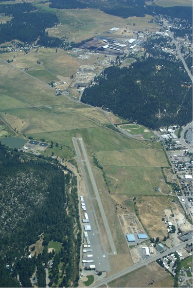
| DUE TO PROXIMITY OF TERRAIN NRML OPNS ARE: FOR DEPS/TOUCH AND GO RWY 07. LDGS ON RWYS 07 AND 25. |
| ULTRALIGHTS ON AND INVOF ARPT. |
| RAPIDLY RISING TERRAIN WITH +100 FT TREES ON NORTH SIDE OF RY. |
| APRT RESTRICTED BY APRT OPER TO ACFT WITH MAX CERT TKOF WEIGHT OF 12,500 LBS OR LESS. |
| FIREFIGHTING ACFT INVOF ARPT MAY-OCT. |
| FOR CD CTC NORCAL APCH AT 916-361-6874. |
| Runway: 07 | Runway: 25 | ||
| Mag heading: | 65° | Mag heading: | 245° |
| Rwy Slope: | -.26% Down | Rwy Slope: | .26% Up |
| Approach: | Approach: | ||
| Pattern: | Left Traffic | Pattern: | Right Traffic |
| Markings: | BASIC | Markings: | BASIC |
| Marking Condition: | GOOD | Marking Condition: | GOOD |
| Arresting Dev: | Arresting Dev: | ||
| Lat & Long: | N3956.6 W12057.2 | Lat. & Long.: | N3956.7 W12056.3 |
| Elev: | 3418.5 ft. MSL | Elev: | 3407.7 ft. MSL |
| TCH: | TCH: | 27 ft. AGL | |
| Visual Glide Path: | Visual Glide Path: | 3.00 degrees | |
| Displaced Threshold: | No | Displaced Threshold: | No |
| Touchdown Zone: | YES | Touchdown Zone: | YES |
| Touchdown Elev.: | 3418.6 feet | Touchdown Elev.: | 3416.7 feet |
| Visual Glide Slope: | Visual Glide Slope: | 2-Light PAPI on LEFT side of Runway | |
| RVR Equipment: | RVR Equipment: | ||
| RVV Equipment: | NO | RVV Equipment: | NO |
| Approach Lights: | Approach Lights: | ||
| REIL: | NO | REIL: | NO |
| Centerline Lights: | NO | Centerline Lights: | NO |
| Touchdown lights: | NO | Touchdown lights: | NO |
| Runway Category: | Runway with a Visual Approach | Runway Category: | Runway with a Visual Approach |
| Declared Distances: | Declared Distances: | ||
| Obstructions: | ROAD | Obstructions: | |
| Marked: | NOT Marked/Lighted | Marked: | |
| Clearance slope: | 7:1; RWY 07 +19 FT ROAD 350 FT FM RWY 7 END 7:1 CLEARANCE SLOPE TO THLD. | Clearance slope: | 50:1 |
| Obstruction height: | 19 feet AGL | Obstruction height: | |
| Dist. from runway: | 350 feet | Dist. from runway: | |
| Centerline offset: | Centerline offset: | ||
| Comments: | Comments: |
Thanks for using FltPlan.com
all rights reserved © 1999-2021 by Flight Plan LLC