
| MOUNT VERNON MUNI MOUNT VERNON MO |
| |
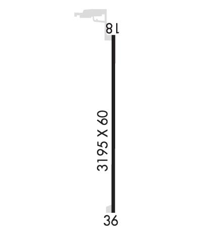
| Lat: N 3704.1 Long: W 09353.1 Elev: 1244 Var: -05 Longest Runway: 3195 | ||
| CTAF: 122.9 | ||
| ||||||||||||||||||||||||||||||||
| ||||||||||||||||||||||||||||||||
| Rwy | Rwy | |||||||
| 3195x60 | 3195' | 3195x60 | 3195' | |||||
| Runway ID | Single Wheel | Double Wheel | Double Tandem Wheel | Dual Double Wheel |
| 18/36 | N/A | N/A | N/A | N/A |
| These numbers are Advisory and are not limits. The Airport Manager should have more accurate Weight Limits | ||||
| FltPlan does not have IFR approach charts available for K2MO. |
 Airport Diagram might not be current. | |
| Facility Name: | MOUNT VERNON MUNI |
| City Name: | MOUNT VERNON |
| County: | LAWRENCE |
| State abbrev: | MO |
| State Name: | MISSOURI |
| Ownership: | PUBLICLY OWNED |
| Use: | OPEN TO THE PUBLIC |
| Owner's Name: | UNIVERSITY OF MISSOURI; SUBLEASED TO THE CITY OF MOUNT VERNON. |
| Address: | ROUTE 3 |
| MOUNT VERNON, MO 65712 | |
| Owner's Phone: | (417) 466-2122 |
| Manager's Name: | MAX SPRINGER; CITY PUBLIC WORKS DIRECTOR. |
| Address: | 319 E. DALLAS, P.O. BOX 70 |
| MOUNT VERNON, MO 65712 | |
| Phone: | 417-466-2122 |
| FAA Region: | CENTRAL |
| FAA Field Office: | NONE |
| Date | Sunrise | Sunset |
|---|---|---|
| 09/24/21 Friday | 7:05 | 19:10 |
| 09/25/21 Saturday | 7:06 | 19:08 |
| 09/26/21 Sunday | 7:06 | 19:07 |
| 09/27/21 Monday | 7:07 | 19:05 |
| 09/28/21 Tuesday | 7:08 | 19:04 |
| 09/29/21 Wednesday | 7:09 | 19:02 |
| 09/30/21 Thursday | 7:10 | 19:01 |
| 10/01/21 Friday | 7:11 | 18:59 |
| 10/02/21 Saturday | 7:12 | 18:58 |
| 10/03/21 Sunday | 7:12 | 18:56 |
| 10/04/21 Monday | 7:13 | 18:55 |
| 10/05/21 Tuesday | 7:14 | 18:53 |
| 10/06/21 Wednesday | 7:15 | 18:52 |
| 10/07/21 Thursday | 7:16 | 18:50 |
| Airport Attendance Schedule | IRREGULAR |
| Airport Status | OPERATIONAL (This Status can change at any time - please check NOTAMS) |
| Airport Lighting Schedule | ACTVT MIRL RY 18/36 - CTAF. |
| Airport Storage Available | Tie Downs |
| Extra Services Available | Parachute Jumping |
| Wind Indicator | YES - (lighted) |
| Control Tower | NO |
| CTAF Frequency | 122.900 |
| Unicom Frequency | |
| Rotating Beacon Color | |
| Segmented Circle | NO |
| Landing Fee | NO |
| Airport Inspected | STATE - performed by STATE AERONAUTICAL PERSONNEL |
| Inspection Date | 06/11/2020 |
| Type of Fuel Available | None |
| Airframe Repair Service | NONE |
| Power Plant Repair Service | NONE |
| Latitude | N3704.1 |
| Longitude | W09353.1 (ESTIMATED) |
| Arpt Elevation | 1244ft (ESTIMATED) |
| Magnetic Variation | 05E |
| 3 miles SW | of MOUNT VERNON |
| Traffic Pattern Altitude | |
| Sectional Chart | KANSAS CITY |
| Operations (Reported) | Yearly | Avg. Daily |
|---|---|---|
| General Aviation Transient | 76 | 0 |
| General Aviation Local | 1045 | 3 |
| Air Taxi | 0 | 0 |
| Commerical | 0 | 0 |
| Commuter | 0 | 0 |
| Military | 0 | 0 |
| Aircraft based on Field | |
|---|---|
| General Aviation Singles | 8 |
| General Aviation Multi | 0 |
| Jet Aircraft | 0 |
| General Aviation Helicopters | 0 |
| Military Aircraft | 0 |
| Gliders | 0 |
| Ultralights | 0 |
| FSS on field | NO |
| FSS tie-in | COLUMBIA |
| FSS Phone | 1-800-WX-BRIEF |
| Who issues Notams | COU |
| Notam D service at airport | YES |
| ARTCC Name | KANSAS CITY |
| Airport Certification | |
| Aircraft Rescue & Firefighting Index | None |
| Airport of Entry | No |
| Custom Landing Rights | No; US CUSTOMS USER FEE ARPT. |
| Joint Civil/Military | No |
| Military Landing rights | No |
| PAJA ON & INVOF ARPT. |
| INSUF RWY SAFETY AREA LENGTH BYND RWY 36 END. |
| FOR CD CTC SPRINGFIELD APCH AT 417-868-5620/5619. |
| Runway: 18 | Runway: 36 | ||
| Mag heading: | 176° | Mag heading: | 356° |
| Rwy Slope: | .63% Up | Rwy Slope: | -.63% Down |
| Approach: | Approach: | ||
| Pattern: | Left Traffic | Pattern: | Right Traffic |
| Markings: | BASIC | Markings: | BASIC |
| Marking Condition: | GOOD | Marking Condition: | GOOD |
| Arresting Dev: | Arresting Dev: | ||
| Lat & Long: | N3704.3 W09353.0 | Lat. & Long.: | N3703.8 W09353.1 |
| Elev: | 1226.0 ft. MSL | Elev: | 1246.0 ft. MSL |
| TCH: | TCH: | ||
| Visual Glide Path: | Visual Glide Path: | ||
| Displaced Threshold: | No | Displaced Threshold: | No |
| Touchdown Zone: | NO | Touchdown Zone: | NO |
| Touchdown Elev.: | Touchdown Elev.: | ||
| Visual Glide Slope: | Visual Glide Slope: | ||
| RVR Equipment: | RVR Equipment: | ||
| RVV Equipment: | NO | RVV Equipment: | NO |
| Approach Lights: | Approach Lights: | ||
| REIL: | NO | REIL: | NO |
| Centerline Lights: | NO | Centerline Lights: | NO |
| Touchdown lights: | NO | Touchdown lights: | NO |
| Runway Category: | Runway with a Visual Approach | Runway Category: | Runway with a Visual Approach |
| Declared Distances: | Declared Distances: | ||
| Obstructions: | Obstructions: | FENCE | |
| Marked: | Marked: | NOT Marked/Lighted | |
| Clearance slope: | 20:1 | Clearance slope: | |
| Obstruction height: | Obstruction height: | 5 feet AGL | |
| Dist. from runway: | Dist. from runway: | 200 feet | |
| Centerline offset: | Centerline offset: | 125 feet right of centerline | |
| Comments: | Comments: | RY 36 1-25 FT BRUSH AND SMALL TREES 195-200 FT FROM RY END L & R. |
Thanks for using FltPlan.com
all rights reserved © 1999-2021 by Flight Plan LLC
