
| PINEVILLE MUNI PINEVILLE LA |
| |
| Lat: N 3120.5 Long: W 09226.6 Elev: 100 Var: -04 Longest Runway: 3000 | ||
| CTAF: 122.8 | ||
| ||||||||||||||||||||||||||||||||||||||||||||
| ||||||||||||||||||||||||||||||||||||||||||||
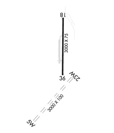
| Rwy | Rwy | |||||||
| 3000x100 | 3000' | 3000x100 | 3000' | |||||
| 3000x75 | 3000' | 3000x75 | 3000' | |||||
| Runway ID | Single Wheel | Double Wheel | Double Tandem Wheel | Dual Double Wheel |
| 05W/23W | N/A | N/A | N/A | N/A |
| 18/36 | 15,500 | N/A | N/A | N/A |
| These numbers are Advisory and are not limits. The Airport Manager should have more accurate Weight Limits | ||||
| FltPlan does not have IFR approach charts available for K2L0. |
 Airport Diagram might not be current. | |
| Facility Name: | PINEVILLE MUNI |
| City Name: | PINEVILLE |
| County: | RAPIDES |
| State abbrev: | LA |
| State Name: | LOUISIANA |
| Ownership: | PUBLICLY OWNED |
| Use: | OPEN TO THE PUBLIC |
| Owner's Name: | CITY OF PINEVILLE |
| Address: | P. O. BOX 3820 |
| PINEVILLE, LA 71361-3820 | |
| Owner's Phone: | 318-445-7163 |
| Manager's Name: | LONNIE LUCIUS |
| Address: | 200 LAKE BUHLOW RD |
| PINEVILLE, LA 71360 | |
| Phone: | 318-449-5679 |
| FAA Region: | SOUTHWEST |
| FAA Field Office: | LNM |
| Date | Sunrise | Sunset |
|---|---|---|
| 06/08/26 Monday | 6:05 | 20:13 |
| 06/09/26 Tuesday | 6:05 | 20:13 |
| 06/10/26 Wednesday | 6:05 | 20:14 |
| 06/11/26 Thursday | 6:05 | 20:14 |
| 06/12/26 Friday | 6:05 | 20:15 |
| 06/13/26 Saturday | 6:05 | 20:15 |
| 06/14/26 Sunday | 6:05 | 20:15 |
| 06/15/26 Monday | 6:05 | 20:16 |
| 06/16/26 Tuesday | 6:05 | 20:16 |
| 06/17/26 Wednesday | 6:05 | 20:16 |
| 06/18/26 Thursday | 6:05 | 20:16 |
| 06/19/26 Friday | 6:05 | 20:17 |
| 06/20/26 Saturday | 6:06 | 20:17 |
| 06/21/26 Sunday | 6:06 | 20:17 |
| Airport Attendance Schedule | SAT 0900-1400, MON-FRI 0800-1800 |
| Airport Status | OPERATIONAL (This Status can change at any time - please check NOTAMS) |
| Airport Lighting Schedule | MIRL RWY 18/36; REIL RWY 18/36 PRESET LOW INTST DUSK-DAWN. TO INCR INTST ACTVT - CTAF. |
| Airport Storage Available | Tie Downs, Hanger |
| Extra Services Available | Charter, Flight Instruction, Aircraft Rental, Annual Surveying |
| Wind Indicator | YES - (lighted) |
| Control Tower | NO |
| CTAF Frequency | 122.800 |
| Unicom Frequency | 122.800 |
| Rotating Beacon Color | WG |
| Segmented Circle | YES |
| Landing Fee | NO |
| Airport Inspected | STATE - performed by STATE AERONAUTICAL PERSONNEL |
| Inspection Date | 01/30/2024 |
| Type of Fuel Available | Grade 100LLMOGAS; -10FUEL AVBL 24/7 WITH CC. |
| Airframe Repair Service | MAJOR |
| Power Plant Repair Service | MAJOR |
| Latitude | N3120.5 |
| Longitude | W09226.6 (ESTIMATED) |
| Arpt Elevation | 100ft (ESTIMATED; WATERWAY ELEV 80 FT.) |
| Magnetic Variation | 04E |
| 2 miles N | of PINEVILLE |
| Traffic Pattern Altitude | TPA 700 FT AGL FOR ACFT FOR WATER RWY 05W/23W, 1000 FT AGL FIXED WING ACFT FOR RWY 18/36. |
| Sectional Chart | HOUSTON |
| Operations (Reported) | Yearly | Avg. Daily |
|---|---|---|
| General Aviation Transient | 0 | 0 |
| General Aviation Local | 0 | 0 |
| Air Taxi | 0 | 0 |
| Commerical | 0 | 0 |
| Commuter | 0 | 0 |
| Military | 0 | 0 |
| Aircraft based on Field | |
|---|---|
| General Aviation Singles | 0 |
| General Aviation Multi | 0 |
| Jet Aircraft | 0 |
| General Aviation Helicopters | 0 |
| Military Aircraft | 0 |
| Gliders | 0 |
| Ultralights | 0 |
| FSS on field | NO |
| FSS tie-in | DE RIDDER |
| FSS Phone | 1-800-WX-BRIEF |
| Who issues Notams | DRI |
| Notam D service at airport | YES |
| ARTCC Name | HOUSTON |
| Airport Certification | |
| Aircraft Rescue & Firefighting Index | None |
| Airport of Entry | No |
| Custom Landing Rights | No |
| Joint Civil/Military | No |
| Military Landing rights | No |
| RWY 36 LAKE 96 FT FM END OF RWY. |
| RWY 18 DROP OFF 95 FT FM END OF RWY. |
| ALL RWY 18/36 SAFETY AREAS NONSTANDARD. |
| FOR CD CTC MAKS APCH AT 726-780-0456. |
| CTC APRT MGR FOR DSGND RAMP SPACE FOR PUB USE. |
| Runway: 05W | Runway: 23W | ||
| Mag heading: | N/A | Mag heading: | N/A |
| Approach: | Approach: | ||
| Pattern: | Left Traffic | Pattern: | Right Traffic |
| Markings: | Markings: | ||
| Marking Condition: | Marking Condition: | ||
| Arresting Dev: | Arresting Dev: | ||
| Lat & Long: | Lat. & Long.: | ||
| Elev: | N/A | Elev: | N/A |
| TCH: | TCH: | ||
| Visual Glide Path: | Visual Glide Path: | ||
| Displaced Threshold: | No | Displaced Threshold: | No |
| Touchdown Zone: | NO | Touchdown Zone: | NO |
| Touchdown Elev.: | Touchdown Elev.: | ||
| Visual Glide Slope: | Visual Glide Slope: | ||
| RVR Equipment: | RVR Equipment: | ||
| RVV Equipment: | NO | RVV Equipment: | NO |
| Approach Lights: | Approach Lights: | ||
| REIL: | NO | REIL: | NO |
| Centerline Lights: | NO | Centerline Lights: | NO |
| Touchdown lights: | NO | Touchdown lights: | NO |
| Runway Category: | Runway with a Visual Approach | Runway Category: | Runway with a Visual Approach |
| Declared Distances: | Declared Distances: |
| Runway: 18 | Runway: 36 | ||
| Mag heading: | N/A | Mag heading: | N/A |
| Rwy Slope: | -.50% Down | Rwy Slope: | .50% Up |
| Approach: | Approach: | ||
| Pattern: | Left Traffic | Pattern: | Left Traffic |
| Markings: | NONPRECISION INSTRUMENT | Markings: | NONPRECISION INSTRUMENT |
| Marking Condition: | POOR; RWY MARKINGS FADED | Marking Condition: | POOR; RWY MARKINGS FADED |
| Arresting Dev: | Arresting Dev: | ||
| Lat & Long: | N3120.8 W09226.6 | Lat. & Long.: | N3120.3 W09226.6 |
| Elev: | 98.0 ft. MSL | Elev: | 83.0 ft. MSL |
| TCH: | 68 ft. AGL | TCH: | 49 ft. AGL |
| Visual Glide Path: | 4.00 degrees | Visual Glide Path: | 3.00 degrees |
| Displaced Threshold: | No | Displaced Threshold: | No |
| Touchdown Zone: | NO | Touchdown Zone: | NO |
| Touchdown Elev.: | Touchdown Elev.: | ||
| Visual Glide Slope: | 2-Light PAPI on LEFT side of Runway | Visual Glide Slope: | 2-Light PAPI on RIGHT side of Runway |
| RVR Equipment: | RVR Equipment: | ||
| RVV Equipment: | NO | RVV Equipment: | NO |
| Approach Lights: | Approach Lights: | ||
| REIL: | YES; REILS OUT OF SERVICE APPROACH END RWY 18 | REIL: | YES; REILS OUT OF SERVICE APPROACH END RWY 36 |
| Centerline Lights: | NO | Centerline Lights: | NO |
| Touchdown lights: | NO | Touchdown lights: | NO |
| Runway Category: | Runway with a Visual Approach | Runway Category: | Runway with a Visual Approach |
| Declared Distances: | Declared Distances: | ||
| Obstructions: | TREES | Obstructions: | TREES |
| Marked: | NOT Marked/Lighted | Marked: | NOT Marked/Lighted |
| Clearance slope: | 13:1 | Clearance slope: | 30:1 |
| Obstruction height: | 95 feet AGL | Obstruction height: | 102 feet AGL |
| Dist. from runway: | 1487 feet | Dist. from runway: | 3264 feet |
| Centerline offset: | 197 left of centerline | Centerline offset: | 170 feet left of centerline |
| Comments: | Comments: |
Thanks for using FltPlan.com
all rights reserved © 1999-2026 by Flight Plan LLC
