
| GARRETT COUNTY OAKLAND MD |
| |
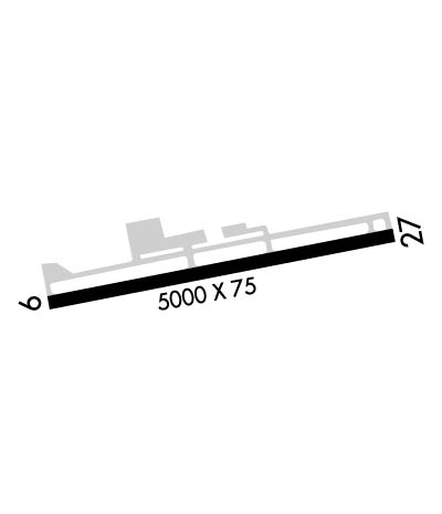
| Lat: N 3934.8 Long: W 07920.2 Elev: 2933 Var: +09 Longest Runway: 5000 | ||
| AWOS: 120.12 CTAF: 123.0 | ||
| ||||||||||||||||||||||||||||||||||||||||||||
| ||||||||||||||||||||||||||||||||||||||||||||
| ||||||||||||||||||||||||||||||||||||||||||||
| Rwy | Rwy | |||||||
| 5000x75 | 5000' | 5000x75 | 5000' | |||||
| Runway ID | Single Wheel | Double Wheel | Double Tandem Wheel | Dual Double Wheel |
| 09/27 | N/A | N/A | N/A | N/A |
| These numbers are Advisory and are not limits. The Airport Manager should have more accurate Weight Limits | ||||
 Airport Diagram might not be current. | |
| Facility Name: | GARRETT COUNTY |
| City Name: | OAKLAND |
| County: | GARRETT |
| State abbrev: | MD |
| State Name: | MARYLAND |
| Ownership: | PUBLICLY OWNED |
| Use: | OPEN TO THE PUBLIC |
| Owner's Name: | BOARD OF CO COMMISSIONERS |
| Address: | 313 EAST ALDER STREET, ROOM 105 |
| OAKLAND, MD 21550 | |
| Owner's Phone: | (301) 334-8970 |
| Manager's Name: | ADISON WYER |
| Address: | 771 AIRPORT ROAD |
| ACCIDENT, MD 21520 | |
| Phone: | 301-746-8599; MGR EMERG NR (301) 616-7467. |
| FAA Region: | EASTERN |
| FAA Field Office: | DCA |
| Date | Sunrise | Sunset |
|---|---|---|
| 06/08/26 Monday | 5:50 | 20:43 |
| 06/09/26 Tuesday | 5:50 | 20:44 |
| 06/10/26 Wednesday | 5:49 | 20:44 |
| 06/11/26 Thursday | 5:49 | 20:45 |
| 06/12/26 Friday | 5:49 | 20:45 |
| 06/13/26 Saturday | 5:49 | 20:46 |
| 06/14/26 Sunday | 5:49 | 20:46 |
| 06/15/26 Monday | 5:49 | 20:46 |
| 06/16/26 Tuesday | 5:49 | 20:47 |
| 06/17/26 Wednesday | 5:49 | 20:47 |
| 06/18/26 Thursday | 5:49 | 20:47 |
| 06/19/26 Friday | 5:50 | 20:48 |
| 06/20/26 Saturday | 5:50 | 20:48 |
| 06/21/26 Sunday | 5:50 | 20:48 |
| Airport Attendance Schedule | 7 Days A Week 0800-1700; UNATNDD CHRISTMAS AND NEW YEARS DAY. |
| Airport Status | OPERATIONAL (This Status can change at any time - please check NOTAMS) |
| Airport Lighting Schedule | ACTVT REIL RWY 09 & 27; PAPI RWY 09 & 27; MIRL RWY 09/27 - CTAF. |
| Airport Storage Available | Tie Downs |
| Extra Services Available | Charter |
| Wind Indicator | YES - (lighted) |
| Control Tower | NO |
| CTAF Frequency | 123.000 |
| Unicom Frequency | 123.000 |
| Rotating Beacon Color | WG |
| Segmented Circle | YES |
| Landing Fee | NO |
| Airport Inspected | STATE - performed by STATE AERONAUTICAL PERSONNEL |
| Inspection Date | 08/26/2025 |
| Type of Fuel Available | Grade 100LL, JET A; -1024 HR SELF SERVE 100LL AND JET-A, W/PRIST AVBL WITH CREDIT CARD. |
| Airframe Repair Service | MINOR |
| Power Plant Repair Service | NONE |
| Latitude | N3934.8 |
| Longitude | W07920.2 (ESTIMATED) |
| Arpt Elevation | 2933ft (SURVEYED) |
| Magnetic Variation | 09W |
| 13 miles NE | of OAKLAND |
| Traffic Pattern Altitude | 800 |
| Sectional Chart | CINCINNATI |
| Operations (Reported) | Yearly | Avg. Daily |
|---|---|---|
| General Aviation Transient | 0 | 0 |
| General Aviation Local | 0 | 0 |
| Air Taxi | 0 | 0 |
| Commerical | 0 | 0 |
| Commuter | 0 | 0 |
| Military | 0 | 0 |
| Aircraft based on Field | |
|---|---|
| General Aviation Singles | 0 |
| General Aviation Multi | 0 |
| Jet Aircraft | 0 |
| General Aviation Helicopters | 0 |
| Military Aircraft | 0 |
| Gliders | 0 |
| Ultralights | 0 |
| FSS on field | NO |
| FSS tie-in | ELKINS |
| FSS Phone | 1-800-WX-BRIEF |
| Who issues Notams | EKN |
| Notam D service at airport | YES |
| ARTCC Name | CLEVELAND |
| Airport Certification | |
| Aircraft Rescue & Firefighting Index | None |
| Airport of Entry | No |
| Custom Landing Rights | No |
| Joint Civil/Military | No |
| Military Landing rights | YES |
| NATIONAL PLAN OF INTEGRATED AIRPORT SYSTEMS (NPIAS) |
| GRANT AGREEMENT HAS EXPIRED; HOWEVER, AGREEMENT REMAINS IN EFFECT FOR THIS FACILITY AS LONG AS IT IS PUBLIC USE. |
| THIS AIRPORT HAS BEEN SURVEYED BY THE NATIONAL GEODETIC SURVEY. |
| WILDLIFE ON AND INVOF ARPT. |
| FOR CD CTC CLARKSBURG APCH AT 304-842-2011, WHEN APCH CLSD CTC CLEVELAND ARTCC AT 440-774-0226. |
Airport Communications & Frequencies:
| |||||||||||||||||
| Runway: 09 | Runway: 27 | ||
| Mag heading: | 88° | Mag heading: | 268° |
| Rwy Slope: | -1.12% Down | Rwy Slope: | 1.12% Up |
| Approach: | Approach: | ||
| Pattern: | Left Traffic | Pattern: | Left Traffic |
| Markings: | NONPRECISION INSTRUMENT | Markings: | NONPRECISION INSTRUMENT |
| Marking Condition: | GOOD | Marking Condition: | GOOD |
| Arresting Dev: | Arresting Dev: | ||
| Lat & Long: | N3934.8 W07920.7 | Lat. & Long.: | N3934.9 W07919.6 |
| Elev: | 2933.1 ft. MSL | Elev: | 2876.9 ft. MSL |
| TCH: | 43 ft. AGL | TCH: | 42 ft. AGL |
| Visual Glide Path: | 3.00 degrees | Visual Glide Path: | 3.00 degrees |
| Displaced Threshold: | No | Displaced Threshold: | No |
| Touchdown Zone: | YES | Touchdown Zone: | YES |
| Touchdown Elev.: | 2933.4 feet | Touchdown Elev.: | 2925.4 feet |
| Visual Glide Slope: | 4-Light PAPI on LEFT side of Runway | Visual Glide Slope: | 4-Light PAPI on LEFT side of Runway |
| RVR Equipment: | RVR Equipment: | ||
| RVV Equipment: | NO | RVV Equipment: | NO |
| Approach Lights: | Approach Lights: | ||
| REIL: | YES | REIL: | YES |
| Centerline Lights: | NO | Centerline Lights: | NO |
| Touchdown lights: | NO | Touchdown lights: | NO |
| Runway Category: | Runway with a Non-precision Approach having visibility minimums greater than 3/4 mile | Runway Category: | Runway with a Non-precision Approach having visibility minimums greater than 3/4 mile |
| Declared Distances: | Declared Distances: |
Thanks for using FltPlan.com
all rights reserved © 1999-2026 by Flight Plan LLC
