
| CONCORD AIRPARK PAINESVILLE OH |
| |
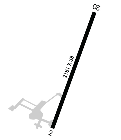
| Lat: N 4140.0 Long: W 08111.8 Elev: 999 Var: +07 Longest Runway: 2181 | ||
| CTAF: 122.8 | ||
| ||||||||||||||||||||||||||||||||
| ||||||||||||||||||||||||||||||||
| Rwy | Rwy | |||||||
| 2181x38 | 2181' | 2181x38 | 2181' | |||||
| Runway ID | Single Wheel | Double Wheel | Double Tandem Wheel | Dual Double Wheel |
| 03/21 | 12,500 | N/A | N/A | N/A |
| These numbers are Advisory and are not limits. The Airport Manager should have more accurate Weight Limits | ||||
 Airport Diagram might not be current. | |
| Facility Name: | CONCORD AIRPARK |
| City Name: | PAINESVILLE |
| County: | LAKE |
| State abbrev: | OH |
| State Name: | OHIO |
| Ownership: | PRIVATELY OWNED |
| Use: | OPEN TO THE PUBLIC |
| Owner's Name: | CONCORD AIRPARK, INC |
| Address: | 12361 CONCORD-HAMBDEN RD |
| PAINESVILLE, OH 44077-9253 | |
| Owner's Phone: | 440-352-3228 |
| Manager's Name: | CONNIE LUHTA |
| Address: | 12253 CONCORD-HAMBDEN RD |
| PAINESVILLE, OH 44077-9566 | |
| Phone: | 440-227-1368 |
| FAA Region: | GREAT LAKES |
| FAA Field Office: | DET |
| Date | Sunrise | Sunset |
|---|---|---|
| 06/08/26 Monday | 5:50 | 20:57 |
| 06/09/26 Tuesday | 5:50 | 20:58 |
| 06/10/26 Wednesday | 5:50 | 20:58 |
| 06/11/26 Thursday | 5:50 | 20:59 |
| 06/12/26 Friday | 5:50 | 21:00 |
| 06/13/26 Saturday | 5:50 | 21:00 |
| 06/14/26 Sunday | 5:50 | 21:00 |
| 06/15/26 Monday | 5:50 | 21:01 |
| 06/16/26 Tuesday | 5:50 | 21:01 |
| 06/17/26 Wednesday | 5:50 | 21:02 |
| 06/18/26 Thursday | 5:50 | 21:02 |
| 06/19/26 Friday | 5:50 | 21:02 |
| 06/20/26 Saturday | 5:50 | 21:02 |
| 06/21/26 Sunday | 5:50 | 21:03 |
| Airport Attendance Schedule | IRREGULAR |
| Airport Status | OPERATIONAL (This Status can change at any time - please check NOTAMS) |
| Airport Lighting Schedule | |
| Airport Storage Available | Tie Downs, Hanger |
| Extra Services Available | NONE |
| Wind Indicator | YES - (unlit) |
| Control Tower | NO |
| CTAF Frequency | 122.800 |
| Unicom Frequency | 122.800 |
| Rotating Beacon Color | |
| Segmented Circle | NO |
| Landing Fee | NO |
| Airport Inspected | STATE - performed by STATE AERONAUTICAL PERSONNEL |
| Inspection Date | 07/10/2025 |
| Type of Fuel Available | None |
| Airframe Repair Service | None |
| Power Plant Repair Service | None |
| Latitude | N4140.0 |
| Longitude | W08111.8 (ESTIMATED) |
| Arpt Elevation | 998ft (SURVEYED) |
| Magnetic Variation | 07W |
| 4 miles SSE | of PAINESVILLE |
| Traffic Pattern Altitude | |
| Sectional Chart | DETROIT |
| Operations (Reported) | Yearly | Avg. Daily |
|---|---|---|
| General Aviation Transient | 0 | 0 |
| General Aviation Local | 0 | 0 |
| Air Taxi | 0 | 0 |
| Commerical | 0 | 0 |
| Commuter | 0 | 0 |
| Military | 0 | 0 |
| Aircraft based on Field | |
|---|---|
| General Aviation Singles | 0 |
| General Aviation Multi | 0 |
| Jet Aircraft | 0 |
| General Aviation Helicopters | 0 |
| Military Aircraft | 0 |
| Gliders | 0 |
| Ultralights | 0 |
| FSS on field | NO |
| FSS tie-in | CLEVELAND |
| FSS Phone | 1-800-WX-BRIEF |
| Who issues Notams | CLE |
| Notam D service at airport | YES |
| ARTCC Name | CLEVELAND |
| Airport Certification | |
| Aircraft Rescue & Firefighting Index | None |
| Airport of Entry | No |
| Custom Landing Rights | No |
| Joint Civil/Military | No |
| Military Landing rights | No |
| THIS AIRPORT HAS BEEN SURVEYED BY THE NATIONAL GEODETIC SURVEY. |
| BIRDS ON & INVOF ARPT. |
| FOR CD CTC CLEVELAND APCH AT 216-352-2323. |
| NGT OPS NA. |
| RWY 03/2 1 EXTSV PAVEMENT CRACKING WI VEGETATION GROWING THRU. |
Airport Communications & Frequencies:
| ||||||||||||||
| Runway: 03 | Runway: 21 | ||
| Mag heading: | 29° | Mag heading: | 209° |
| Rwy Slope: | -1.22% Down | Rwy Slope: | 1.22% Up |
| Approach: | Approach: | ||
| Pattern: | Left Traffic | Pattern: | Left Traffic |
| Markings: | BASIC | Markings: | BASIC |
| Marking Condition: | POOR; FADED. | Marking Condition: | POOR; FADED. |
| Arresting Dev: | Arresting Dev: | ||
| Lat & Long: | N4139.9 W08111.9 | Lat. & Long.: | N4140.2 W08111.7 |
| Elev: | 994.1 ft. MSL | Elev: | 967.6 ft. MSL |
| TCH: | TCH: | ||
| Visual Glide Path: | Visual Glide Path: | ||
| Displaced Threshold: | No | Displaced Threshold: | No |
| Touchdown Zone: | YES | Touchdown Zone: | YES |
| Touchdown Elev.: | 998.6 feet | Touchdown Elev.: | 998.6 feet |
| Visual Glide Slope: | Visual Glide Slope: | ||
| RVR Equipment: | RVR Equipment: | ||
| RVV Equipment: | NO | RVV Equipment: | NO |
| Approach Lights: | Approach Lights: | ||
| REIL: | NO | REIL: | NO |
| Centerline Lights: | NO | Centerline Lights: | NO |
| Touchdown lights: | NO | Touchdown lights: | NO |
| Runway Category: | Runway with a Visual Approach | Runway Category: | Runway with a Visual Approach |
| Declared Distances: | Declared Distances: | ||
| Obstructions: | TREES | Obstructions: | TREES |
| Marked: | NOT Marked/Lighted | Marked: | NOT Marked/Lighted |
| Clearance slope: | 1:1 | Clearance slope: | 1:1 |
| Obstruction height: | 73 feet AGL | Obstruction height: | 75 feet AGL |
| Dist. from runway: | 258 feet | Dist. from runway: | 201 feet |
| Centerline offset: | 64 right of centerline | Centerline offset: | 121 feet right of centerline |
| Comments: | 40 FT TREES 50-199 FT DSTC 125 FT L & R. | Comments: | 20-50 FT TREES 0 FT DSTC. |
Thanks for using FltPlan.com
all rights reserved © 1999-2026 by Flight Plan LLC
