
| OAKES MUNI OAKES ND |
| |
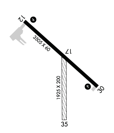
| Lat: N 4610.4 Long: W 09804.8 Elev: 1335 Var: -07 Longest Runway: 3505 | ||
| AWOS: 118.67 CTAF: 122.9 | ||
| ||||||||||||||||||||||||||||||||||||||||||||
| ||||||||||||||||||||||||||||||||||||||||||||
| ||||||||||||||||||||||||||||||||||||||||||||
| Rwy | Rwy | |||||||
| 3505x60 | 3505' | 3505x60 | 3505' | |||||
| 2001x120 | 2001' | 2001x120 | 2001' | |||||
| Runway ID | Single Wheel | Double Wheel | Double Tandem Wheel | Dual Double Wheel |
| 12/30 | 12,500 | N/A | N/A | N/A |
| 17/35 | N/A | N/A | N/A | N/A |
| H1 | N/A | N/A | N/A | N/A |
| These numbers are Advisory and are not limits. The Airport Manager should have more accurate Weight Limits | ||||
 Airport Diagram might not be current. | |
| Facility Name: | OAKES MUNI |
| City Name: | OAKES |
| County: | DICKEY |
| State abbrev: | ND |
| State Name: | NORTH DAKOTA |
| Ownership: | PUBLICLY OWNED |
| Use: | OPEN TO THE PUBLIC |
| Owner's Name: | OAKES ARPT AUTH |
| Address: | 115 SOUTH 5TH ST |
| OAKES, ND 58474 | |
| Owner's Phone: | 701-742-2137; ARPT AUTHORITY CLERK. |
| Manager's Name: | TRAVIS MCPHERSON |
| Address: | 8550 HWY 1 |
| OAKES, ND 58474 | |
| Phone: | 701-710-1220; ADL CONTACT GARY SCHNELL 701-678-4910, DEAN SCHMIT 701-678-4661, SCOTT GERMAN 701-710-0624. |
| FAA Region: | GREAT LAKES |
| FAA Field Office: | DMA |
| Date | Sunrise | Sunset |
|---|---|---|
| 06/12/26 Friday | 5:40 | 21:24 |
| 06/13/26 Saturday | 5:40 | 21:25 |
| 06/14/26 Sunday | 5:40 | 21:25 |
| 06/15/26 Monday | 5:40 | 21:26 |
| 06/16/26 Tuesday | 5:40 | 21:26 |
| 06/17/26 Wednesday | 5:40 | 21:26 |
| 06/18/26 Thursday | 5:40 | 21:27 |
| 06/19/26 Friday | 5:40 | 21:27 |
| 06/20/26 Saturday | 5:40 | 21:27 |
| 06/21/26 Sunday | 5:41 | 21:27 |
| 06/22/26 Monday | 5:41 | 21:28 |
| 06/23/26 Tuesday | 5:41 | 21:28 |
| 06/24/26 Wednesday | 5:41 | 21:28 |
| 06/25/26 Thursday | 5:42 | 21:28 |
| Airport Attendance Schedule | 7 Days A Week ON CALL; ON CALL AFTER HRS 701-710-1220. |
| Airport Status | OPERATIONAL (This Status can change at any time - please check NOTAMS) |
| Airport Lighting Schedule | ACTVT MIRL RY 12/30 & PAPI RYS 12 & 30 - CTAF. |
| Airport Storage Available | Tie Downs, Hanger |
| Extra Services Available | Crop Dusting |
| Wind Indicator | YES - (lighted) |
| Control Tower | NO |
| CTAF Frequency | 122.900 |
| Unicom Frequency | |
| Rotating Beacon Color | WG |
| Segmented Circle | YES |
| Landing Fee | NO |
| Airport Inspected | STATE - performed by STATE AERONAUTICAL PERSONNEL |
| Inspection Date | 08/21/2025 |
| Type of Fuel Available | None |
| Airframe Repair Service | MINOR |
| Power Plant Repair Service | MINOR |
| Latitude | N4610.4 |
| Longitude | W09804.8 (ESTIMATED) |
| Arpt Elevation | 1334ft (ESTIMATED) |
| Magnetic Variation | 07E |
| 2 miles N | of OAKES |
| Traffic Pattern Altitude | |
| Sectional Chart | TWIN CITIES |
| Operations (Reported) | Yearly | Avg. Daily |
|---|---|---|
| General Aviation Transient | 0 | 0 |
| General Aviation Local | 0 | 0 |
| Air Taxi | 0 | 0 |
| Commerical | 0 | 0 |
| Commuter | 0 | 0 |
| Military | 0 | 0 |
| Aircraft based on Field | |
|---|---|
| General Aviation Singles | 0 |
| General Aviation Multi | 0 |
| Jet Aircraft | 0 |
| General Aviation Helicopters | 0 |
| Military Aircraft | 0 |
| Gliders | 0 |
| Ultralights | 0 |
| FSS on field | NO |
| FSS tie-in | GRAND FORKS |
| FSS Phone | 1-800-WX-BRIEF |
| Who issues Notams | GFK |
| Notam D service at airport | YES |
| ARTCC Name | MINNEAPOLIS |
| Airport Certification | |
| Aircraft Rescue & Firefighting Index | None |
| Airport of Entry | No |
| Custom Landing Rights | No |
| Joint Civil/Military | No |
| Military Landing rights | YES |
| NATIONAL PLAN OF INTEGRATED AIRPORT SYSTEMS (NPIAS) |
| GRANT AGREEMENTS UNDER FAAP/ADAP/AIP |
| ASSURANCES PURSUANT TO TITLE VI, CIVIL RIGHTS ACT OF 1964 |
| CFM ARPT CONDS WINTER MONTHS BFR USE CALL 701-710-1220 OR 701-678-4661. |
| RWY 17/35 CLSD WINTER MONTHS NO SNOW REMOVAL. |
| FBO HRS MON-FRI 0800-1700 FREQ 122.9. |
| FOR CD CTC MINNEAPOLIS ARTCC AT 651-463-5588. |
Airport Communications & Frequencies:
| |||||||
| Runway: 12 | Runway: 30 | ||
| Mag heading: | 124° | Mag heading: | 304° |
| Rwy Slope: | .13% Up | Rwy Slope: | -.13% Down |
| Approach: | Approach: | ||
| Pattern: | Left Traffic | Pattern: | Left Traffic |
| Markings: | NONPRECISION INSTRUMENT | Markings: | NONPRECISION INSTRUMENT |
| Marking Condition: | GOOD | Marking Condition: | GOOD |
| Arresting Dev: | Arresting Dev: | ||
| Lat & Long: | N4610.6 W09805.1 | Lat. & Long.: | N4610.3 W09804.5 |
| Elev: | 1330.4 ft. MSL | Elev: | 1334.9 ft. MSL |
| TCH: | 27 ft. AGL | TCH: | 27 ft. AGL |
| Visual Glide Path: | 3.00 degrees | Visual Glide Path: | 3.00 degrees |
| Displaced Threshold: | No | Displaced Threshold: | No |
| Touchdown Zone: | YES | Touchdown Zone: | YES |
| Touchdown Elev.: | 1334.9 feet | Touchdown Elev.: | 1334.9 feet |
| Visual Glide Slope: | 2-Light PAPI on LEFT side of Runway | Visual Glide Slope: | 2-Light PAPI on LEFT side of Runway |
| RVR Equipment: | RVR Equipment: | ||
| RVV Equipment: | NO | RVV Equipment: | NO |
| Approach Lights: | Approach Lights: | ||
| REIL: | NO | REIL: | NO |
| Centerline Lights: | NO | Centerline Lights: | NO |
| Touchdown lights: | NO | Touchdown lights: | NO |
| Runway Category: | Runway with a Visual Approach | Runway Category: | Runway with a Non-precision Approach |
| Declared Distances: | Declared Distances: | ||
| Obstructions: | OTHER; MOBILE IRRIGATOR INTMTLY IN APCH L & R OF CNTRLN. | Obstructions: | |
| Marked: | NOT Marked/Lighted | Marked: | |
| Clearance slope: | 7:1 | Clearance slope: | 20:1 |
| Obstruction height: | 14 feet AGL | Obstruction height: | |
| Dist. from runway: | 300 feet | Dist. from runway: | |
| Centerline offset: | 265 left of centerline | Centerline offset: | |
| Comments: | Comments: |
| Runway: 17 | Runway: 35 | ||
| Mag heading: | 173° | Mag heading: | 353° |
| Rwy Slope: | -.04% Down | Rwy Slope: | .04% Up |
| Approach: | Approach: | ||
| Pattern: | Left Traffic | Pattern: | Left Traffic |
| Markings: | NONE | Markings: | NONE |
| Marking Condition: | Marking Condition: | ||
| Arresting Dev: | Arresting Dev: | ||
| Lat & Long: | N4610.5 W09804.8 | Lat. & Long.: | N4610.1 W09804.8 |
| Elev: | 1333.5 ft. MSL | Elev: | 1332.7 ft. MSL |
| TCH: | TCH: | ||
| Visual Glide Path: | Visual Glide Path: | ||
| Displaced Threshold: | No | Displaced Threshold: | No |
| Touchdown Zone: | YES | Touchdown Zone: | YES |
| Touchdown Elev.: | 1333.5 feet | Touchdown Elev.: | 1333.5 feet |
| Visual Glide Slope: | Visual Glide Slope: | ||
| RVR Equipment: | RVR Equipment: | ||
| RVV Equipment: | NO | RVV Equipment: | NO |
| Approach Lights: | Approach Lights: | ||
| REIL: | NO | REIL: | NO |
| Centerline Lights: | NO | Centerline Lights: | NO |
| Touchdown lights: | NO | Touchdown lights: | NO |
| Runway Category: | Runway with a Visual Approach | Runway Category: | Runway with a Visual Approach |
| Declared Distances: | Declared Distances: |
Thanks for using FltPlan.com
all rights reserved © 1999-2026 by Flight Plan LLC
