
| HOLLEY MOUNTAIN AIRPARK CLINTON AR |
| |
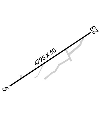
| Lat: N 3539.0 Long: W 09224.2 Elev: 1269 Var: -02 Longest Runway: 4795 | ||
| CTAF: 122.7 | ||
| ||||||||||||||||||||||||||||||||
| ||||||||||||||||||||||||||||||||
| Rwy | Rwy | |||||||
| 4795x50 | 4397' | 4795x50 | 4795' | |||||
| Runway ID | Single Wheel | Double Wheel | Double Tandem Wheel | Dual Double Wheel |
| 05/23 | N/A | N/A | N/A | N/A |
| These numbers are Advisory and are not limits. The Airport Manager should have more accurate Weight Limits | ||||
 Airport Diagram might not be current. | |
| Facility Name: | HOLLEY MOUNTAIN AIRPARK |
| City Name: | CLINTON |
| County: | VAN BUREN |
| State abbrev: | AR |
| State Name: | ARKANSAS |
| Ownership: | PRIVATELY OWNED |
| Use: | OPEN TO THE PUBLIC |
| Owner's Name: | HOLLEY MOUNTAIN P.O.A. |
| Address: | 302 NORTHRIDGE RD. |
| CLINTON, AR 72031 | |
| Owner's Phone: | (501) 253-4590 |
| Manager's Name: | MIKE FOOTE |
| Address: | 302 NORTHRIDGE RD. |
| CLINTON, AR 72031 | |
| Phone: | 501-253-4590 |
| FAA Region: | SOUTHWEST |
| FAA Field Office: | AOK |
| Date | Sunrise | Sunset |
|---|---|---|
| 09/24/21 Friday | 6:59 | 19:04 |
| 09/25/21 Saturday | 7:00 | 19:02 |
| 09/26/21 Sunday | 7:00 | 19:01 |
| 09/27/21 Monday | 7:01 | 18:59 |
| 09/28/21 Tuesday | 7:02 | 18:58 |
| 09/29/21 Wednesday | 7:03 | 18:57 |
| 09/30/21 Thursday | 7:04 | 18:55 |
| 10/01/21 Friday | 7:04 | 18:54 |
| 10/02/21 Saturday | 7:05 | 18:52 |
| 10/03/21 Sunday | 7:06 | 18:51 |
| 10/04/21 Monday | 7:07 | 18:49 |
| 10/05/21 Tuesday | 7:08 | 18:48 |
| 10/06/21 Wednesday | 7:08 | 18:47 |
| 10/07/21 Thursday | 7:09 | 18:45 |
| Airport Attendance Schedule | UNATTENDED |
| Airport Status | OPERATIONAL (This Status can change at any time - please check NOTAMS) |
| Airport Lighting Schedule | ACTVT MIRL RY 05/23, REIL RYS 05 & 23, VASI RY 05 & WINDSOCK - CTAF. |
| Airport Storage Available | NONE |
| Extra Services Available | NONE |
| Wind Indicator | YES - (lighted) |
| Control Tower | NO |
| CTAF Frequency | 122.700 |
| Unicom Frequency | 122.700 |
| Rotating Beacon Color | CLEAR-GREEN (Light Land Airport) |
| Segmented Circle | NO |
| Landing Fee |
| Airport Inspected | STATE - performed by STATE AERONAUTICAL PERSONNEL |
| Inspection Date | 10/08/2020 |
| Type of Fuel Available | None |
| Airframe Repair Service | None |
| Power Plant Repair Service | None |
| Latitude | N3539.0 |
| Longitude | W09224.2 (ESTIMATED) |
| Arpt Elevation | 1269ft (SURVEYED) |
| Magnetic Variation | 02E |
| 5 miles NE | of CLINTON |
| Traffic Pattern Altitude | |
| Sectional Chart | MEMPHIS |
| Operations (Reported) | Yearly | Avg. Daily |
|---|---|---|
| General Aviation Transient | 1000 | 3 |
| General Aviation Local | 2000 | 5 |
| Air Taxi | 0 | 0 |
| Commerical | 0 | 0 |
| Commuter | 0 | 0 |
| Military | 300 | 1 |
| Aircraft based on Field | |
|---|---|
| General Aviation Singles | 17 |
| General Aviation Multi | 1 |
| Jet Aircraft | 1 |
| General Aviation Helicopters | 0 |
| Military Aircraft | 0 |
| Gliders | 0 |
| Ultralights | 0 |
| FSS on field | NO |
| FSS tie-in | JONESBORO |
| FSS Phone | 1-800-WX-BRIEF |
| Who issues Notams | JBR |
| Notam D service at airport | YES |
| ARTCC Name | MEMPHIS |
| Airport Certification | |
| Aircraft Rescue & Firefighting Index | None |
| Airport of Entry | No |
| Custom Landing Rights | No |
| Joint Civil/Military | No |
| Military Landing rights | No |
| DEER ON & INVOF RY. |
| BEGINNING 10 FT BYD EAST END OF RWY 23 PAVEMENT, GND HAS APRX 10FT DROP OVER 40 FT LEN. |
| BEGINNING 50 FT BYD WEST END OF RWY 5 PAVEMENT, GND HAS APROX 25 FT DROP OVER 125 FT LEN. |
| RY 05/23 CLSD TO ACFT GROSS WT GREATER THAN 12,500 LBS. |
| FOR CD CTC MEMPHIS ARTCC AT 901-368-8453/8449. |
| WX INFO - CTAF (6 CLICKS). |
Airport Communications & Frequencies:
| |||||||||
| Runway: 05 | Runway: 23 | ||
| Mag heading: | 55° | Mag heading: | 235° |
| Rwy Slope: | .00% | Rwy Slope: | .00% |
| Approach: | Approach: | ||
| Pattern: | Left Traffic | Pattern: | Right Traffic |
| Markings: | NONPRECISION INSTRUMENT | Markings: | NONPRECISION INSTRUMENT |
| Marking Condition: | FAIR | Marking Condition: | FAIR |
| Arresting Dev: | Arresting Dev: | ||
| Lat & Long: | N3538.8 W09224.6 | Lat. & Long.: | N3539.3 W09223.8 |
| Elev: | 1270.0 ft. MSL | Elev: | 1270.0 ft. MSL |
| TCH: | 31 ft. AGL | TCH: | 47 ft. AGL |
| Visual Glide Path: | 3.50 degrees | Visual Glide Path: | 3.00 degrees |
| Displaced Threshold: | 398 feet | Displaced Threshold: | No |
| Touchdown Zone: | YES | Touchdown Zone: | YES |
| Touchdown Elev.: | 1270.0 feet | Touchdown Elev.: | 1270.0 feet |
| Visual Glide Slope: | 2-Box VASI on LEFT side of Runway; VASI UNUSABLE BYD 2 DEGS LEFT & 7 DEGS RIGHT OF CENTERLINE. | Visual Glide Slope: | 2-Light PAPI on LEFT side of Runway |
| RVR Equipment: | RVR Equipment: | ||
| RVV Equipment: | NO | RVV Equipment: | NO |
| Approach Lights: | Approach Lights: | ||
| REIL: | YES | REIL: | YES |
| Centerline Lights: | NO | Centerline Lights: | NO |
| Touchdown lights: | NO | Touchdown lights: | NO |
| Runway Category: | Runway with a Visual Approach | Runway Category: | Runway with a Visual Approach |
| Declared Distances: | Declared Distances: | ||
| Obstructions: | TREES | Obstructions: | TREES |
| Marked: | NOT Marked/Lighted | Marked: | NOT Marked/Lighted |
| Clearance slope: | 6:1; APCH SLOPE 18:1 TO DTHR. | Clearance slope: | 32:1 |
| Obstruction height: | 50 feet AGL | Obstruction height: | 5 feet AGL |
| Dist. from runway: | 500 feet | Dist. from runway: | 360 feet |
| Centerline offset: | 35 right of centerline | Centerline offset: | 120 feet right of centerline |
| Comments: | Comments: |
Thanks for using FltPlan.com
all rights reserved © 1999-2021 by Flight Plan LLC
