
| MARK ANTON DAYTON TN |
| |
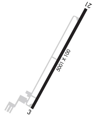
| Lat: N 3529.2 Long: W 08455.9 Elev: 718 Var: +04 Longest Runway: 5001 | ||
| AWOS: 135.07 CTAF: 123.0 | ||
| ||||||||||||||||||||||||||||||||||||||||||||
| ||||||||||||||||||||||||||||||||||||||||||||
| ||||||||||||||||||||||||||||||||||||||||||||
| Rwy | Rwy | |||||||
| 5001x100 | 5001' | 5001x100 | 5001' | |||||
| Runway ID | Single Wheel | Double Wheel | Double Tandem Wheel | Dual Double Wheel |
| 03/21 | 43,500 | 62,000 | N/A | N/A |
| These numbers are Advisory and are not limits. The Airport Manager should have more accurate Weight Limits | ||||
 Airport Diagram might not be current. | |
| Facility Name: | MARK ANTON |
| City Name: | DAYTON |
| County: | RHEA |
| State abbrev: | TN |
| State Name: | TENNESSEE |
| Ownership: | PUBLICLY OWNED |
| Use: | OPEN TO THE PUBLIC |
| Owner's Name: | CITY OF DAYTON |
| Address: | P.O. BOX 226 |
| DAYTON, TN 37321 | |
| Owner's Phone: | 423-775-1818 |
| Manager's Name: | BRYAN JANISCH |
| Address: | 350 WALTER SQUIRE RD |
| DAYTON, TN 37321 | |
| Phone: | 423-775-8407 |
| FAA Region: | SOUTHERN |
| FAA Field Office: | MEM |
| Date | Sunrise | Sunset |
|---|---|---|
| 06/12/26 Friday | 6:24 | 20:55 |
| 06/13/26 Saturday | 6:24 | 20:56 |
| 06/14/26 Sunday | 6:24 | 20:56 |
| 06/15/26 Monday | 6:24 | 20:57 |
| 06/16/26 Tuesday | 6:24 | 20:57 |
| 06/17/26 Wednesday | 6:24 | 20:57 |
| 06/18/26 Thursday | 6:24 | 20:58 |
| 06/19/26 Friday | 6:24 | 20:58 |
| 06/20/26 Saturday | 6:24 | 20:58 |
| 06/21/26 Sunday | 6:25 | 20:58 |
| 06/22/26 Monday | 6:25 | 20:58 |
| 06/23/26 Tuesday | 6:25 | 20:59 |
| 06/24/26 Wednesday | 6:25 | 20:59 |
| 06/25/26 Thursday | 6:26 | 20:59 |
| Airport Attendance Schedule | MON-SAT 0900-1700, SUN 1300-1700; CLSD FED HOL. AFT HR TRML DOOR CODE - UNICOM. |
| Airport Status | OPERATIONAL (This Status can change at any time - please check NOTAMS) |
| Airport Lighting Schedule | SS-SR |
| Airport Storage Available | Tie Downs |
| Extra Services Available | Avionics, Flight Instruction |
| Wind Indicator | YES - (lighted) |
| Control Tower | NO |
| CTAF Frequency | 123.000 |
| Unicom Frequency | 123.000 |
| Rotating Beacon Color | WG |
| Segmented Circle | YES |
| Landing Fee | NO |
| Airport Inspected | STATE - performed by STATE AERONAUTICAL PERSONNEL |
| Inspection Date | 05/15/2024 |
| Type of Fuel Available | Grade 100LL, JET A; -10SELF SVC. |
| Airframe Repair Service | MAJOR |
| Power Plant Repair Service | MAJOR |
| Latitude | N3529.2 |
| Longitude | W08455.9 (ESTIMATED) |
| Arpt Elevation | 718ft (SURVEYED) |
| Magnetic Variation | 04W |
| 4 miles E | of DAYTON |
| Traffic Pattern Altitude | |
| Sectional Chart | ATLANTA |
| Operations (Reported) | Yearly | Avg. Daily |
|---|---|---|
| General Aviation Transient | 0 | 0 |
| General Aviation Local | 0 | 0 |
| Air Taxi | 0 | 0 |
| Commerical | 0 | 0 |
| Commuter | 0 | 0 |
| Military | 0 | 0 |
| Aircraft based on Field | |
|---|---|
| General Aviation Singles | 0 |
| General Aviation Multi | 0 |
| Jet Aircraft | 0 |
| General Aviation Helicopters | 0 |
| Military Aircraft | 0 |
| Gliders | 0 |
| Ultralights | 0 |
| FSS on field | NO |
| FSS tie-in | NASHVILLE |
| FSS Phone | 1-800-WX-BRIEF |
| Who issues Notams | BNA |
| Notam D service at airport | YES |
| ARTCC Name | ATLANTA |
| Airport Certification | |
| Aircraft Rescue & Firefighting Index | None |
| Airport of Entry | No |
| Custom Landing Rights | No |
| Joint Civil/Military | No |
| Military Landing rights | YES |
| NATIONAL PLAN OF INTEGRATED AIRPORT SYSTEMS (NPIAS) |
| GRANT AGREEMENTS UNDER FAAP/ADAP/AIP |
| ASSURANCES PURSUANT TO TITLE VI, CIVIL RIGHTS ACT OF 1964 |
| THIS AIRPORT HAS BEEN SURVEYED BY THE NATIONAL GEODETIC SURVEY. |
| FOR CD CTC CHATTANOOGA APCH AT 423-855-6478, WHEN APCH CLSD CTC ATLANTA ARTCC AT 770-210-7692. |
| WILDLIFE INVOF ARPT. |
Airport Communications & Frequencies:
| |||||||||||||||||
| Runway: 03 | Runway: 21 | ||
| Mag heading: | 33° | Mag heading: | 213° |
| Rwy Slope: | .15% Up | Rwy Slope: | -.15% Down |
| Approach: | Approach: | ||
| Pattern: | Left Traffic | Pattern: | Left Traffic |
| Markings: | NONPRECISION INSTRUMENT | Markings: | NONPRECISION INSTRUMENT |
| Marking Condition: | GOOD | Marking Condition: | GOOD |
| Arresting Dev: | Arresting Dev: | ||
| Lat & Long: | N3528.8 W08456.1 | Lat. & Long.: | N3529.5 W08455.6 |
| Elev: | 710.7 ft. MSL | Elev: | 718.2 ft. MSL |
| TCH: | 31 ft. AGL | TCH: | 31 ft. AGL |
| Visual Glide Path: | 3.00 degrees | Visual Glide Path: | 3.00 degrees |
| Displaced Threshold: | No | Displaced Threshold: | No |
| Touchdown Zone: | YES | Touchdown Zone: | YES |
| Touchdown Elev.: | 714.3 feet | Touchdown Elev.: | 718.2 feet |
| Visual Glide Slope: | 2-Light PAPI on LEFT side of Runway | Visual Glide Slope: | 2-Light PAPI on LEFT side of Runway |
| RVR Equipment: | RVR Equipment: | ||
| RVV Equipment: | NO | RVV Equipment: | NO |
| Approach Lights: | Approach Lights: | ||
| REIL: | YES | REIL: | YES |
| Centerline Lights: | NO | Centerline Lights: | NO |
| Touchdown lights: | NO | Touchdown lights: | NO |
| Runway Category: | Runway with a Non-precision Approach having visibility minimums greater than 3/4 mile | Runway Category: | Runway with a Non-precision Approach having visibility minimums greater than 3/4 mile |
| Declared Distances: | Declared Distances: | ||
| Obstructions: | TREE | Obstructions: | TREE |
| Marked: | NOT Marked/Lighted | Marked: | NOT Marked/Lighted |
| Clearance slope: | 29:1 | Clearance slope: | 25:1 |
| Obstruction height: | 21 feet AGL | Obstruction height: | 86 feet AGL |
| Dist. from runway: | 810 feet | Dist. from runway: | 2360 feet |
| Centerline offset: | 69 right of centerline | Centerline offset: | 572 feet left of centerline |
| Comments: | Comments: |
Thanks for using FltPlan.com
all rights reserved © 1999-2026 by Flight Plan LLC
