
| MC DERMITT STATE MC DERMITT OR |
| |
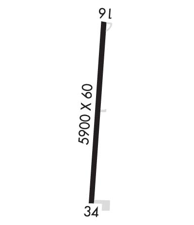
| Lat: N 4200.6 Long: W 11743.6 Elev: 4478 Var: -17 Longest Runway: 5900 | ||
| CTAF: 122.9 | ||
| ||||||||||||||||||||||||||||||||
| ||||||||||||||||||||||||||||||||
| Rwy | Rwy | |||||||
| 5900x60 | 5900' | 5900x60 | 5900' | |||||
| Runway ID | Single Wheel | Double Wheel | Double Tandem Wheel | Dual Double Wheel |
| 16/34 | 12,500 | N/A | N/A | N/A |
| These numbers are Advisory and are not limits. The Airport Manager should have more accurate Weight Limits | ||||
| FltPlan does not have IFR approach charts available for K26U. |
 Airport Diagram might not be current. | |
| Facility Name: | MC DERMITT STATE |
| City Name: | MC DERMITT |
| County: | MALHEUR |
| State abbrev: | OR |
| State Name: | OREGON |
| Ownership: | PUBLICLY OWNED |
| Use: | OPEN TO THE PUBLIC |
| Owner's Name: | OREGON DEPARTMENT OF AVIATION |
| Address: | 3040 25TH ST SE |
| SALEM, OR 97302-1125 | |
| Owner's Phone: | 503-378-4880 |
| Manager's Name: | STATE AIRPORTS MANAGER |
| Address: | 3040 25TH ST SE |
| SALEM, OR 97302-1125 | |
| Phone: | 503-378-4880 |
| FAA Region: | NORTHWEST MOUNTAIN |
| FAA Field Office: | SEA |
| Date | Sunrise | Sunset |
|---|---|---|
| 06/08/26 Monday | 5:15 | 20:25 |
| 06/09/26 Tuesday | 5:15 | 20:25 |
| 06/10/26 Wednesday | 5:15 | 20:26 |
| 06/11/26 Thursday | 5:15 | 20:26 |
| 06/12/26 Friday | 5:15 | 20:27 |
| 06/13/26 Saturday | 5:15 | 20:27 |
| 06/14/26 Sunday | 5:15 | 20:28 |
| 06/15/26 Monday | 5:15 | 20:28 |
| 06/16/26 Tuesday | 5:15 | 20:29 |
| 06/17/26 Wednesday | 5:15 | 20:29 |
| 06/18/26 Thursday | 5:15 | 20:29 |
| 06/19/26 Friday | 5:15 | 20:30 |
| 06/20/26 Saturday | 5:15 | 20:30 |
| 06/21/26 Sunday | 5:15 | 20:30 |
| Airport Attendance Schedule | UNATTENDED |
| Airport Status | OPERATIONAL (This Status can change at any time - please check NOTAMS) |
| Airport Lighting Schedule | ACTVT MIRL RWY 16/34 - CTAF. |
| Airport Storage Available | Tie Downs |
| Extra Services Available | NONE |
| Wind Indicator | YES - (lighted) |
| Control Tower | NO |
| CTAF Frequency | 122.900 |
| Unicom Frequency | |
| Rotating Beacon Color | WG |
| Segmented Circle | YES |
| Landing Fee | NO |
| Airport Inspected | STATE - performed by STATE AERONAUTICAL PERSONNEL |
| Inspection Date | 09/19/2024 |
| Type of Fuel Available | None |
| Airframe Repair Service | NONE |
| Power Plant Repair Service | NONE |
| Latitude | N4200.6 |
| Longitude | W11743.6 (ESTIMATED) |
| Arpt Elevation | 4478ft (ESTIMATED) |
| Magnetic Variation | 17E |
| 0 miles W | of MC DERMITT |
| Traffic Pattern Altitude | |
| Sectional Chart | KLAMATH FALLS |
| Operations (Reported) | Yearly | Avg. Daily |
|---|---|---|
| General Aviation Transient | 0 | 0 |
| General Aviation Local | 0 | 0 |
| Air Taxi | 0 | 0 |
| Commerical | 0 | 0 |
| Commuter | 0 | 0 |
| Military | 0 | 0 |
| Aircraft based on Field | |
|---|---|
| General Aviation Singles | 0 |
| General Aviation Multi | 0 |
| Jet Aircraft | 0 |
| General Aviation Helicopters | 0 |
| Military Aircraft | 0 |
| Gliders | 0 |
| Ultralights | 0 |
| FSS on field | NO |
| FSS tie-in | MC MINNVILLE |
| FSS Phone | 1-800-WX-BRIEF |
| Who issues Notams | MMV |
| Notam D service at airport | YES |
| ARTCC Name | SALT LAKE CITY |
| Airport Certification | |
| Aircraft Rescue & Firefighting Index | None |
| Airport of Entry | No |
| Custom Landing Rights | No |
| Joint Civil/Military | No |
| Military Landing rights | No |
| NATIONAL PLAN OF INTEGRATED AIRPORT SYSTEMS (NPIAS) |
| GRANT AGREEMENTS UNDER FAAP/ADAP/AIP |
| ASSURANCES PURSUANT TO TITLE VI, CIVIL RIGHTS ACT OF 1964 |
| RISING TERRAIN TO NORTH OF ARPT AT APPROXIMATELY 2% FOR 10000 FT. |
| SURFACE CONDITIONS NOT REPORTED. |
| FOR CD CTC SALT LAKE ARTCC AT 801-320-2568. |
| Runway: 16 | Runway: 34 | ||
| Mag heading: | 166° | Mag heading: | 346° |
| Rwy Slope: | -1.00% Down | Rwy Slope: | 1.00% Up |
| Approach: | Approach: | ||
| Pattern: | Left Traffic | Pattern: | Left Traffic |
| Markings: | BASIC | Markings: | BASIC |
| Marking Condition: | GOOD | Marking Condition: | GOOD |
| Arresting Dev: | Arresting Dev: | ||
| Lat & Long: | N4201.1 W11743.6 | Lat. & Long.: | N4200.1 W11743.7 |
| Elev: | 4478.0 ft. MSL | Elev: | 4419.0 ft. MSL |
| TCH: | TCH: | ||
| Visual Glide Path: | Visual Glide Path: | ||
| Displaced Threshold: | No | Displaced Threshold: | No |
| Touchdown Zone: | NO | Touchdown Zone: | NO |
| Touchdown Elev.: | Touchdown Elev.: | ||
| Visual Glide Slope: | Visual Glide Slope: | ||
| RVR Equipment: | RVR Equipment: | ||
| RVV Equipment: | NO | RVV Equipment: | NO |
| Approach Lights: | Approach Lights: | ||
| REIL: | NO | REIL: | NO |
| Centerline Lights: | NO | Centerline Lights: | NO |
| Touchdown lights: | NO | Touchdown lights: | NO |
| Runway Category: | Runway with a Visual Approach | Runway Category: | Runway with a Visual Approach |
| Declared Distances: | Declared Distances: |
Thanks for using FltPlan.com
all rights reserved © 1999-2026 by Flight Plan LLC
