
| DILLEY AIRPARK DILLEY TX |
| |
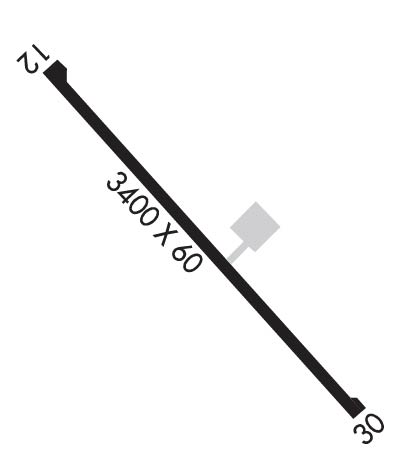
| Lat: N 2841.1 Long: W 09911.3 Elev: 542 Var: -08 Longest Runway: 3400 | ||
| CTAF: 122.9 | ||
| ||||||||||||||||||||||||||||||||
| ||||||||||||||||||||||||||||||||
| Rwy | Rwy | |||||||
| 3400x60 | 3400' | 3400x60 | 3400' | |||||
| Runway ID | Single Wheel | Double Wheel | Double Tandem Wheel | Dual Double Wheel |
| 12/30 | 12,500 | N/A | N/A | N/A |
| These numbers are Advisory and are not limits. The Airport Manager should have more accurate Weight Limits | ||||
| FltPlan does not have IFR approach charts available for K24R. |
 Airport Diagram might not be current. | |
| Facility Name: | DILLEY AIRPARK |
| City Name: | DILLEY |
| County: | FRIO |
| State abbrev: | TX |
| State Name: | TEXAS |
| Ownership: | PUBLICLY OWNED |
| Use: | OPEN TO THE PUBLIC |
| Owner's Name: | CITY OF DILLEY |
| Address: | PO BOX 230 |
| DILLEY, TX 78017 | |
| Owner's Phone: | 830-965-1624 |
| Manager's Name: | JUAN ESTRADA; CITY ADMINISTRATOR / ARPT MGR. |
| Address: | PO BOX 230 |
| DILLEY, TX 78017 | |
| Phone: | 830-965-1624 |
| FAA Region: | SOUTHWEST |
| FAA Field Office: | TEX |
| Date | Sunrise | Sunset |
|---|---|---|
| 09/24/21 Friday | 7:26 | 19:31 |
| 09/25/21 Saturday | 7:27 | 19:30 |
| 09/26/21 Sunday | 7:27 | 19:29 |
| 09/27/21 Monday | 7:28 | 19:27 |
| 09/28/21 Tuesday | 7:28 | 19:26 |
| 09/29/21 Wednesday | 7:29 | 19:25 |
| 09/30/21 Thursday | 7:29 | 19:24 |
| 10/01/21 Friday | 7:30 | 19:23 |
| 10/02/21 Saturday | 7:30 | 19:22 |
| 10/03/21 Sunday | 7:31 | 19:20 |
| 10/04/21 Monday | 7:31 | 19:19 |
| 10/05/21 Tuesday | 7:32 | 19:18 |
| 10/06/21 Wednesday | 7:32 | 19:17 |
| 10/07/21 Thursday | 7:33 | 19:16 |
| Airport Attendance Schedule | UNATTENDED |
| Airport Status | OPERATIONAL (This Status can change at any time - please check NOTAMS) |
| Airport Lighting Schedule | DUSK-2300; DUSK-2300 |
| Airport Storage Available | Tie Downs |
| Extra Services Available | NONE |
| Wind Indicator | YES - (lighted) |
| Control Tower | NO |
| CTAF Frequency | 122.900 |
| Unicom Frequency | |
| Rotating Beacon Color | CLEAR-GREEN (Light Land Airport); ROTG BCN OTS INDEFLY. |
| Segmented Circle | YES |
| Landing Fee | NO |
| Airport Inspected | STATE - performed by PRIVATE CONTRACT PERSONNEL |
| Inspection Date | 05/07/2020 |
| Type of Fuel Available | None |
| Airframe Repair Service | None |
| Power Plant Repair Service | None |
| Latitude | N2841.1 |
| Longitude | W09911.3 (ESTIMATED) |
| Arpt Elevation | 542ft (SURVEYED) |
| Magnetic Variation | 08E |
| 2 miles NW | of DILLEY |
| Traffic Pattern Altitude | |
| Sectional Chart | SAN ANTONIO |
| Operations (Reported) | Yearly | Avg. Daily |
|---|---|---|
| General Aviation Transient | 100 | 0 |
| General Aviation Local | 50 | 0 |
| Air Taxi | 0 | 0 |
| Commerical | 0 | 0 |
| Commuter | 0 | 0 |
| Military | 0 | 0 |
| Aircraft based on Field | |
|---|---|
| General Aviation Singles | 0 |
| General Aviation Multi | 0 |
| Jet Aircraft | 0 |
| General Aviation Helicopters | 0 |
| Military Aircraft | 0 |
| Gliders | 0 |
| Ultralights | 0 |
| FSS on field | NO |
| FSS tie-in | SAN ANGELO |
| FSS Phone | 1-800-WX-BRIEF |
| Who issues Notams | SJT |
| Notam D service at airport | YES |
| ARTCC Name | HOUSTON |
| Airport Certification | |
| Aircraft Rescue & Firefighting Index | None |
| Airport of Entry | No |
| Custom Landing Rights | No |
| Joint Civil/Military | No |
| Military Landing rights | No |
| 4 FT FENCE 250 FT FM RWY 12 THR BOTH SIDES OF CNTRLN. |
| +15-30 FT TREES 150 FT EAST OF CNTRLN 475 FT FM RWY 12 THR ALG EAST SIDE OF RWY. |
| FOR CD CTC HOUSTON ARTCC AT 281-230-5622. |
| RWY 12/3 0 LIRL OTS INDEFLY. |
| Runway: 12 | Runway: 30 | ||
| Mag heading: | 121° | Mag heading: | 301° |
| Rwy Slope: | .44% Up | Rwy Slope: | -.44% Down |
| Approach: | Approach: | ||
| Pattern: | Left Traffic | Pattern: | Left Traffic |
| Markings: | BASIC | Markings: | BASIC |
| Marking Condition: | GOOD | Marking Condition: | GOOD |
| Arresting Dev: | Arresting Dev: | ||
| Lat & Long: | N2841.3 W09911.6 | Lat. & Long.: | N2841.0 W09911.1 |
| Elev: | 527.0 ft. MSL | Elev: | 542.0 ft. MSL |
| TCH: | TCH: | ||
| Visual Glide Path: | Visual Glide Path: | ||
| Displaced Threshold: | No | Displaced Threshold: | No |
| Touchdown Zone: | NO | Touchdown Zone: | NO |
| Touchdown Elev.: | Touchdown Elev.: | ||
| Visual Glide Slope: | Visual Glide Slope: | ||
| RVR Equipment: | RVR Equipment: | ||
| RVV Equipment: | NO | RVV Equipment: | NO |
| Approach Lights: | Approach Lights: | ||
| REIL: | NO | REIL: | NO |
| Centerline Lights: | NO | Centerline Lights: | NO |
| Touchdown lights: | NO | Touchdown lights: | NO |
| Runway Category: | Runway with a Visual Approach | Runway Category: | Runway with a Visual Approach |
| Declared Distances: | Declared Distances: | ||
| Obstructions: | TREES | Obstructions: | ROAD |
| Marked: | NOT Marked/Lighted | Marked: | NOT Marked/Lighted |
| Clearance slope: | 4:1 | Clearance slope: | |
| Obstruction height: | 15 feet AGL | Obstruction height: | 10 feet AGL |
| Dist. from runway: | 268 feet | Dist. from runway: | 200 feet |
| Centerline offset: | 62 right of centerline | Centerline offset: | |
| Comments: | Comments: |
Thanks for using FltPlan.com
all rights reserved © 1999-2021 by Flight Plan LLC
