
| CYPRESS RIVER JEFFERSON TX |
| |
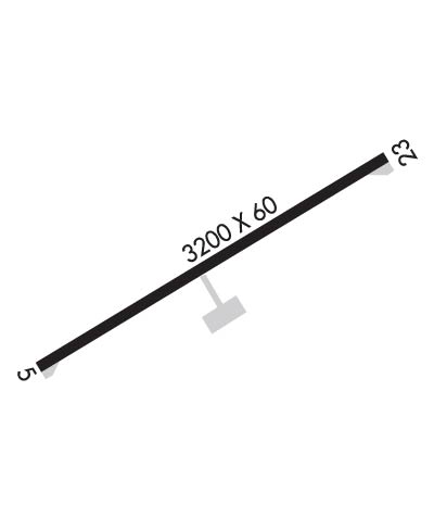
| Lat: N 3244.7 Long: W 09418.3 Elev: 222 Var: -05 Longest Runway: 3200 | ||
| CTAF: 122.9 | ||
| ||||||||||||||||||||||||||||||||
| ||||||||||||||||||||||||||||||||
| Rwy | Rwy | |||||||
| 3200x60 | 3200' | 3200x60 | 3200' | |||||
| Runway ID | Single Wheel | Double Wheel | Double Tandem Wheel | Dual Double Wheel |
| 05/23 | 12,500 | N/A | N/A | N/A |
| These numbers are Advisory and are not limits. The Airport Manager should have more accurate Weight Limits | ||||
| FltPlan does not have IFR approach charts available for K24F. |
 Airport Diagram might not be current. | |
| Facility Name: | CYPRESS RIVER |
| City Name: | JEFFERSON |
| County: | MARION |
| State abbrev: | TX |
| State Name: | TEXAS |
| Ownership: | PUBLICLY OWNED |
| Use: | OPEN TO THE PUBLIC |
| Owner's Name: | MARION COUNTY |
| Address: | 119 W. LAFAYETTE ST. ROOM 206, ROOM 206 |
| JEFFERSON, TX 75657 | |
| Owner's Phone: | 903-665-3261; ALSO 906-665-8336 SANDRA WRIGHT ADMIN ASST TO CO JUDGE & CO COMM. |
| Manager's Name: | TED MCKINNON |
| Address: | 119 W. LAFAYETTE ST. ROOM 206, ROOM 206 |
| JEFFERSON, TX 75657 | |
| Phone: | 903-240-7707 |
| FAA Region: | SOUTHWEST |
| FAA Field Office: | TEX |
| Date | Sunrise | Sunset |
|---|---|---|
| 06/12/26 Friday | 6:09 | 20:26 |
| 06/13/26 Saturday | 6:09 | 20:26 |
| 06/14/26 Sunday | 6:09 | 20:26 |
| 06/15/26 Monday | 6:09 | 20:27 |
| 06/16/26 Tuesday | 6:09 | 20:27 |
| 06/17/26 Wednesday | 6:09 | 20:27 |
| 06/18/26 Thursday | 6:09 | 20:28 |
| 06/19/26 Friday | 6:09 | 20:28 |
| 06/20/26 Saturday | 6:09 | 20:28 |
| 06/21/26 Sunday | 6:10 | 20:28 |
| 06/22/26 Monday | 6:10 | 20:28 |
| 06/23/26 Tuesday | 6:10 | 20:29 |
| 06/24/26 Wednesday | 6:10 | 20:29 |
| 06/25/26 Thursday | 6:11 | 20:29 |
| Airport Attendance Schedule | 7 Days A Week IREG |
| Airport Status | OPERATIONAL (This Status can change at any time - please check NOTAMS) |
| Airport Lighting Schedule | SS-SR |
| Airport Storage Available | Tie Downs, Hanger |
| Extra Services Available | NONE |
| Wind Indicator | YES - (lighted) |
| Control Tower | NO |
| CTAF Frequency | 122.900 |
| Unicom Frequency | |
| Rotating Beacon Color | WG |
| Segmented Circle | NO |
| Landing Fee | NO |
| Airport Inspected | CONTRACTOR - performed by PRIVATE CONTRACT PERSONNEL |
| Inspection Date | 05/04/2025 |
| Type of Fuel Available | Grade 100LL; -1024 HR SELF SERV. |
| Airframe Repair Service | NONE |
| Power Plant Repair Service | NONE |
| Latitude | N3244.7 |
| Longitude | W09418.3 (ESTIMATED) |
| Arpt Elevation | 221ft (SURVEYED) |
| Magnetic Variation | 05E |
| 3 miles E | of JEFFERSON |
| Traffic Pattern Altitude | |
| Sectional Chart | MEMPHIS |
| Operations (Reported) | Yearly | Avg. Daily |
|---|---|---|
| General Aviation Transient | 0 | 0 |
| General Aviation Local | 0 | 0 |
| Air Taxi | 0 | 0 |
| Commerical | 0 | 0 |
| Commuter | 0 | 0 |
| Military | 0 | 0 |
| Aircraft based on Field | |
|---|---|
| General Aviation Singles | 0 |
| General Aviation Multi | 0 |
| Jet Aircraft | 0 |
| General Aviation Helicopters | 0 |
| Military Aircraft | 0 |
| Gliders | 0 |
| Ultralights | 0 |
| FSS on field | NO |
| FSS tie-in | FORT WORTH |
| FSS Phone | 1-800-WX-BRIEF |
| Who issues Notams | FTW |
| Notam D service at airport | YES |
| ARTCC Name | FORT WORTH |
| Airport Certification | |
| Aircraft Rescue & Firefighting Index | None |
| Airport of Entry | No |
| Custom Landing Rights | No |
| Joint Civil/Military | No |
| Military Landing rights | No |
| ASSURANCES PURSUANT TO TITLE VI, CIVIL RIGHTS ACT OF 1964 |
| GRANT AGREEMENT HAS EXPIRED; HOWEVER, AGREEMENT REMAINS IN EFFECT FOR THIS FACILITY AS LONG AS IT IS PUBLIC USE. |
| BIRDS & DEER ON & INVOF ARPT. |
| FOR CD CTC FORT WORTH ARTCC AT 817-858-7584. |
| TO ARRANGE COURTESY CAR CALL 903-240-7707 MON-FRI 0800-1700. |
| Runway: 05 | Runway: 23 | ||
| Mag heading: | 54° | Mag heading: | 234° |
| Rwy Slope: | .01% Up | Rwy Slope: | -.01% Down |
| Approach: | Approach: | ||
| Pattern: | Left Traffic | Pattern: | Left Traffic |
| Markings: | BASIC | Markings: | BASIC |
| Marking Condition: | GOOD | Marking Condition: | GOOD |
| Arresting Dev: | Arresting Dev: | ||
| Lat & Long: | N3244.5 W09418.5 | Lat. & Long.: | N3244.8 W09418.0 |
| Elev: | 216.1 ft. MSL | Elev: | 216.5 ft. MSL |
| TCH: | 45 ft. AGL | TCH: | 45 ft. AGL |
| Visual Glide Path: | 3.50 degrees | Visual Glide Path: | 3.50 degrees |
| Displaced Threshold: | No | Displaced Threshold: | No |
| Touchdown Zone: | YES | Touchdown Zone: | YES |
| Touchdown Elev.: | 221.6 feet | Touchdown Elev.: | 221.6 feet |
| Visual Glide Slope: | 2-Light PAPI on LEFT side of Runway; UNUSBL BYD 9 DEG LEFT OF RCL. | Visual Glide Slope: | 2-Light PAPI on LEFT side of Runway; UNUSBL BYD 7 DEG LEFT OF RCL. |
| RVR Equipment: | RVR Equipment: | ||
| RVV Equipment: | NO | RVV Equipment: | NO |
| Approach Lights: | Approach Lights: | ||
| REIL: | NO | REIL: | NO |
| Centerline Lights: | NO | Centerline Lights: | NO |
| Touchdown lights: | NO | Touchdown lights: | NO |
| Runway Category: | Runway with a Visual Approach | Runway Category: | Runway with a Visual Approach |
| Declared Distances: | Declared Distances: | ||
| Obstructions: | TREES | Obstructions: | TREES |
| Marked: | NOT Marked/Lighted | Marked: | NOT Marked/Lighted |
| Clearance slope: | 18:1 | Clearance slope: | 22:1 |
| Obstruction height: | 120 feet AGL | Obstruction height: | 93 feet AGL |
| Dist. from runway: | 2400 feet | Dist. from runway: | 2275 feet |
| Centerline offset: | 690 right of centerline | Centerline offset: | 650 feet right of centerline |
| Comments: | Comments: |
Thanks for using FltPlan.com
all rights reserved © 1999-2026 by Flight Plan LLC
