| JACKSON COUNTY SYLVA NC |
| |
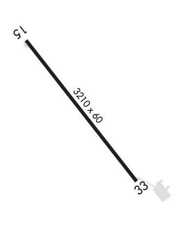
| Lat: N 3519.0 Long: W 08312.6 Elev: 2857 Var: +05 Longest Runway: 3210 | ||
| CTAF: 123.0 | ||
| |||||||||||||||||||||||
| |||||||||||||||||||||||
| Rwy | Rwy | |||||||
| 3210x60 | 3210' | 3210x60 | 3060' | |||||
| Runway ID | Single Wheel | Double Wheel | Double Tandem Wheel | Dual Double Wheel |
| 15/33 | 12,500 | N/A | N/A | N/A |
| These numbers are Advisory and are not limits. The Airport Manager should have more accurate Weight Limits | ||||
 Airport Diagram might not be current. | |
| Facility Name: | JACKSON COUNTY |
| City Name: | SYLVA |
| County: | JACKSON |
| State abbrev: | NC |
| State Name: | NORTH CAROLINA |
| Ownership: | PUBLICLY OWNED |
| Use: | OPEN TO THE PUBLIC |
| Owner's Name: | JACKSON CO ARPT AUTHORITY |
| Address: | 401 GRINDSTAFF COVE RD, SUITE A-207 |
| SYLVA, NC 28779 | |
| Owner's Phone: | 828-631-2295 |
| Manager's Name: | JIM ROWELL |
| Address: | 401 GRINDSTAFF COVE RD, SUITE A-207 |
| SYLVA, NC 28779 | |
| Phone: | 828-586-0321 |
| FAA Region: | SOUTHERN |
| FAA Field Office: | MEM |
| Date | Sunrise | Sunset |
|---|---|---|
| 06/08/26 Monday | 6:18 | 20:46 |
| 06/09/26 Tuesday | 6:18 | 20:47 |
| 06/10/26 Wednesday | 6:17 | 20:47 |
| 06/11/26 Thursday | 6:17 | 20:48 |
| 06/12/26 Friday | 6:17 | 20:48 |
| 06/13/26 Saturday | 6:17 | 20:48 |
| 06/14/26 Sunday | 6:17 | 20:49 |
| 06/15/26 Monday | 6:17 | 20:49 |
| 06/16/26 Tuesday | 6:18 | 20:50 |
| 06/17/26 Wednesday | 6:18 | 20:50 |
| 06/18/26 Thursday | 6:18 | 20:50 |
| 06/19/26 Friday | 6:18 | 20:50 |
| 06/20/26 Saturday | 6:18 | 20:51 |
| 06/21/26 Sunday | 6:18 | 20:51 |
| Airport Attendance Schedule | UNATTENDED |
| Airport Status | OPERATIONAL (This Status can change at any time - please check NOTAMS) |
| Airport Lighting Schedule | AFTER SS ACTVT REIL RWY 33; PAPI RWY 15 & 33; MIRL RWY 15/33 - CTAF. |
| Airport Storage Available | Tie Downs |
| Extra Services Available | NONE |
| Wind Indicator | YES - (lighted) |
| Control Tower | NO |
| CTAF Frequency | 123.000 |
| Unicom Frequency | 123.000 |
| Rotating Beacon Color | WG |
| Segmented Circle | YES |
| Landing Fee | NO |
| Airport Inspected | STATE - performed by STATE AERONAUTICAL PERSONNEL |
| Inspection Date | 07/26/2023 |
| Type of Fuel Available | Grade 100LL; -10FUEL 24 HOUR CREDIT CARD SVC AVBL. |
| Airframe Repair Service | NONE |
| Power Plant Repair Service | NONE |
| Latitude | N3519.0 |
| Longitude | W08312.6 (ESTIMATED) |
| Arpt Elevation | 2857ft (SURVEYED) |
| Magnetic Variation | 05W |
| 3 miles SE | of SYLVA |
| Traffic Pattern Altitude | |
| Sectional Chart | ATLANTA |
| Operations (Reported) | Yearly | Avg. Daily |
|---|---|---|
| General Aviation Transient | 0 | 0 |
| General Aviation Local | 0 | 0 |
| Air Taxi | 0 | 0 |
| Commerical | 0 | 0 |
| Commuter | 0 | 0 |
| Military | 0 | 0 |
| Aircraft based on Field | |
|---|---|
| General Aviation Singles | 0 |
| General Aviation Multi | 0 |
| Jet Aircraft | 0 |
| General Aviation Helicopters | 0 |
| Military Aircraft | 0 |
| Gliders | 0 |
| Ultralights | 0 |
| FSS on field | NO |
| FSS tie-in | RALEIGH |
| FSS Phone | 1-800-WX-BRIEF |
| Who issues Notams | RDU |
| Notam D service at airport | YES |
| ARTCC Name | ATLANTA |
| Airport Certification | |
| Aircraft Rescue & Firefighting Index | None |
| Airport of Entry | No |
| Custom Landing Rights | No |
| Joint Civil/Military | No |
| Military Landing rights | YES |
| NATIONAL PLAN OF INTEGRATED AIRPORT SYSTEMS (NPIAS) |
| GRANT AGREEMENTS UNDER FAAP/ADAP/AIP |
| ASSURANCES PURSUANT TO TITLE VI, CIVIL RIGHTS ACT OF 1964 |
| NO DSGND HELI AT THIS ARPT - ARPT MASTER RECORD INCORRECTLY DESIGNATES H1 EXISTS. |
| MTN HAZ RED BCN LGTS LCTD ON MTN RANGE APPROX 1.7 MILES SSW OF ARPT - LGTS OPN UNRELBL. |
| RWY 15 300 FT DROP-OFF 300 FT FM THLD BOTH SIDES AND 90 FT LEFT/RIGHT OF CNTRLN ALONG RWY. |
| RWY 33 300 FT DROP-OFF 200 FT FM THLD 50 FT LEFT OF CNTRLN. |
| RPDLY RSG TRRN ALL QUADS. |
| FOR CD CTC ATLANTA ARTCC AT 770-210-7692. |
| COLD TEMPERATURE AIRPORT. ALTITUDE CORRECTION REQUIRED AT OR BELOW -13C. |
Airport Communications & Frequencies:
| |||||||||
| Runway: 15 | Runway: 33 | ||
| Mag heading: | 147° | Mag heading: | 327° |
| Rwy Slope: | -1.56% Down | Rwy Slope: | 1.56% Up |
| Approach: | Approach: | ||
| Pattern: | Left Traffic | Pattern: | Left Traffic |
| Markings: | NONPRECISION INSTRUMENT | Markings: | NONPRECISION INSTRUMENT |
| Marking Condition: | GOOD | Marking Condition: | GOOD |
| Arresting Dev: | Arresting Dev: | ||
| Lat & Long: | N3519.2 W08312.8 | Lat. & Long.: | N3518.8 W08312.4 |
| Elev: | 2856.6 ft. MSL | Elev: | 2806.6 ft. MSL |
| TCH: | 30 ft. AGL | TCH: | 29 ft. AGL |
| Visual Glide Path: | 3.50 degrees | Visual Glide Path: | 3.09 degrees |
| Displaced Threshold: | No | Displaced Threshold: | 150 feet |
| Touchdown Zone: | YES | Touchdown Zone: | YES |
| Touchdown Elev.: | 2856.6 feet | Touchdown Elev.: | 2807.4 feet |
| Visual Glide Slope: | 2-Light PAPI on LEFT side of Runway; UNUSBL BYD 8 DEG LEFT OF CNTRLN. | Visual Glide Slope: | 2-Light PAPI on LEFT side of Runway |
| RVR Equipment: | RVR Equipment: | ||
| RVV Equipment: | NO | RVV Equipment: | NO |
| Approach Lights: | Approach Lights: | ||
| REIL: | YES; NOTAM IN EFFECT - OTS INDEFLY. | REIL: | YES |
| Centerline Lights: | NO | Centerline Lights: | NO |
| Touchdown lights: | NO | Touchdown lights: | NO |
| Runway Category: | Runway with a Visual Approach | Runway Category: | Runway with a Non-precision Approach |
| Declared Distances: | Declared Distances: | ||
| Obstructions: | TREES | Obstructions: | BRUSH |
| Marked: | NOT Marked/Lighted | Marked: | NOT Marked/Lighted |
| Clearance slope: | 33:1 | Clearance slope: | 3:1; DSPLD THLD SLOPE 18:1 . |
| Obstruction height: | 13 feet AGL | Obstruction height: | 10 feet AGL |
| Dist. from runway: | 640 feet | Dist. from runway: | 236 feet |
| Centerline offset: | 91 right of centerline | Centerline offset: | 25 feet left of centerline |
| Comments: | Comments: |
Thanks for using FltPlan.com
all rights reserved © 1999-2026 by Flight Plan LLC