
| LAKE ELMO ST PAUL MN |
| |
| Lat: N 4459.8 Long: W 09251.3 Elev: 933 Var: -01 Longest Runway: 2849 | ||
| Clr Del: 118.62 AWOS: 120.07 CTAF: 122.8 | ||
| ||||||||||||||||||||||||||||||||||||||||||||
| ||||||||||||||||||||||||||||||||||||||||||||
| ||||||||||||||||||||||||||||||||||||||||||||
| Rwy | Rwy | |||||||
| 2496x75 | 2496' | 2496x75 | 2496' | |||||
| 2849x75 | 2849' | 2849x75 | 2849' | |||||
| Runway ID | Single Wheel | Double Wheel | Double Tandem Wheel | Dual Double Wheel |
| 04/22 | 13,000 | N/A | N/A | N/A |
| 14/32 | 11,000 | N/A | N/A | N/A |
| These numbers are Advisory and are not limits. The Airport Manager should have more accurate Weight Limits | ||||
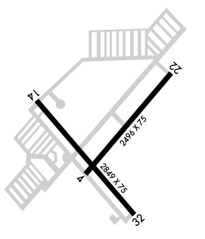 Airport Diagram might not be current. | |
| Facility Name: | LAKE ELMO |
| City Name: | ST PAUL |
| County: | WASHINGTON |
| State abbrev: | MN |
| State Name: | MINNESOTA |
| Ownership: | PUBLICLY OWNED |
| Use: | OPEN TO THE PUBLIC |
| Owner's Name: | METROPOLITAN AIRPORT CMSN |
| Address: | 6040 28TH AVENUE SO. |
| MINNEAPOLIS, MN 55450 | |
| Owner's Phone: | 612-726-8100 |
| Manager's Name: | PHILIP TIEDEMAN; MAINT SUPVR 612-919-3508, MON-FRI 0600-1430. |
| Address: | 6040 28TH AVENUE SO.; MGR EMAIL: PHILIP.TIEDEMAN@MSPMAC.ORG |
| MINNEAPOLIS, MN 55450 | |
| Phone: | 763-717-0001; MGR EMAIL: PHILIP.TIEDEMAN@MSPMAC.ORG |
| FAA Region: | GREAT LAKES |
| FAA Field Office: | DMA |
| Date | Sunrise | Sunset |
|---|---|---|
| 09/24/21 Friday | 7:01 | 19:06 |
| 09/25/21 Saturday | 7:02 | 19:04 |
| 09/26/21 Sunday | 7:03 | 19:02 |
| 09/27/21 Monday | 7:04 | 19:00 |
| 09/28/21 Tuesday | 7:05 | 18:58 |
| 09/29/21 Wednesday | 7:07 | 18:56 |
| 09/30/21 Thursday | 7:08 | 18:54 |
| 10/01/21 Friday | 7:09 | 18:52 |
| 10/02/21 Saturday | 7:10 | 18:50 |
| 10/03/21 Sunday | 7:12 | 18:49 |
| 10/04/21 Monday | 7:13 | 18:47 |
| 10/05/21 Tuesday | 7:14 | 18:45 |
| 10/06/21 Wednesday | 7:15 | 18:43 |
| 10/07/21 Thursday | 7:17 | 18:41 |
| Airport Attendance Schedule | APR-OCT 7 Days A Week 0700-1900, NOV-MAR 7 Days A Week 0700-1700 |
| Airport Status | OPERATIONAL (This Status can change at any time - please check NOTAMS) |
| Airport Lighting Schedule | MIRL RY 14/32 PRESET TO LOW, TO INCR INTST AND ACTVT REIL RYS 14 & 32 AND PAPI RY 32 - CTAF. |
| Airport Storage Available | Tie Downs, Hanger |
| Extra Services Available | Flight Instruction, Aircraft Rental, Aircraft Sales |
| Wind Indicator | YES - (lighted) |
| Control Tower | NO |
| CTAF Frequency | 122.800 |
| Unicom Frequency | 122.800 |
| Rotating Beacon Color | CLEAR-GREEN (Light Land Airport) |
| Segmented Circle | NO |
| Landing Fee | NO |
| Airport Inspected | STATE - performed by STATE AERONAUTICAL PERSONNEL |
| Inspection Date | 08/14/2019 |
| Type of Fuel Available | Grade 100LL, JET A (freeze point -40C); -10SELF SVC FUEL AVBL 24 HR WITH CREDIT CARD. |
| Airframe Repair Service | MAJOR |
| Power Plant Repair Service | MAJOR |
| Latitude | N4459.8 |
| Longitude | W09251.3 (ESTIMATED) |
| Arpt Elevation | 932ft (SURVEYED) |
| Magnetic Variation | 01E |
| 9 miles E | of ST PAUL |
| Traffic Pattern Altitude | |
| Sectional Chart | GREEN BAY |
| Operations (Reported) | Yearly | Avg. Daily |
|---|---|---|
| General Aviation Transient | 14561 | 40 |
| General Aviation Local | 10621 | 29 |
| Air Taxi | 1147 | 3 |
| Commerical | 0 | 0 |
| Commuter | 0 | 0 |
| Military | 169 | 0 |
| Aircraft based on Field | |
|---|---|
| General Aviation Singles | 162 |
| General Aviation Multi | 4 |
| Jet Aircraft | 0 |
| General Aviation Helicopters | 3 |
| Military Aircraft | 0 |
| Gliders | 0 |
| Ultralights | 0 |
| FSS on field | NO |
| FSS tie-in | PRINCETON |
| FSS Phone | 1-800-WX-BRIEF |
| Who issues Notams | 21D |
| Notam D service at airport | YES |
| ARTCC Name | MINNEAPOLIS |
| Airport Certification | |
| Aircraft Rescue & Firefighting Index | None |
| Airport of Entry | No |
| Custom Landing Rights | No |
| Joint Civil/Military | No |
| Military Landing rights | YES |
| NATIONAL PLAN OF INTEGRATED AIRPORT SYSTEMS (NPIAS) |
| GRANT AGREEMENTS UNDER FAAP/ADAP/AIP |
| ASSURANCES PURSUANT TO TITLE VI, CIVIL RIGHTS ACT OF 1964 |
| ULTRALIGHT OPNS PROHIBITED. |
| FOR NOISE ABATEMENT PROCEDURES, WWW.MACNOISE.COM/PILOTS. ACFT PLEASE FOLLOW VOLUNTARY NOISE ABATEMENT PROCEDURES. |
| DEER, BIRDS & WILDLIFE ON & INVOF ARPT. |
| FOR CD CTC MINNEAPOLIS APCH AT 612-726-9086. |
| RWY 32 DSGND AS CALM WND RWY. |
Airport Communications & Frequencies:
| ||||||||||||||||
| Runway: 04 | Runway: 22 | ||
| Mag heading: | 38° | Mag heading: | 218° |
| Rwy Slope: | .36% Up | Rwy Slope: | -.36% Down |
| Approach: | Approach: | ||
| Pattern: | Left Traffic | Pattern: | Left Traffic |
| Markings: | NONPRECISION INSTRUMENT | Markings: | BASIC |
| Marking Condition: | GOOD | Marking Condition: | GOOD |
| Arresting Dev: | Arresting Dev: | ||
| Lat & Long: | N4459.7 W09251.4 | Lat. & Long.: | N4500.1 W09251.1 |
| Elev: | 923.9 ft. MSL | Elev: | 932.9 ft. MSL |
| TCH: | TCH: | ||
| Visual Glide Path: | Visual Glide Path: | ||
| Displaced Threshold: | No | Displaced Threshold: | No |
| Touchdown Zone: | YES | Touchdown Zone: | YES |
| Touchdown Elev.: | 932.9 feet | Touchdown Elev.: | 932.9 feet |
| Visual Glide Slope: | Visual Glide Slope: | ||
| RVR Equipment: | RVR Equipment: | ||
| RVV Equipment: | NO | RVV Equipment: | NO |
| Approach Lights: | Approach Lights: | ||
| REIL: | NO | REIL: | NO |
| Centerline Lights: | NO | Centerline Lights: | NO |
| Touchdown lights: | NO | Touchdown lights: | NO |
| Runway Category: | Runway with a Non-precision Approach | Runway Category: | Runway with a Visual Approach |
| Declared Distances: | Declared Distances: | ||
| Obstructions: | TREES | Obstructions: | Unknown |
| Marked: | NOT Marked/Lighted | Marked: | NOT Marked/Lighted |
| Clearance slope: | 20:1 | Clearance slope: | 14:1 |
| Obstruction height: | 64 feet AGL | Obstruction height: | 27 feet AGL |
| Dist. from runway: | 1530 feet | Dist. from runway: | 579 feet |
| Centerline offset: | 74 right of centerline | Centerline offset: | 240 feet right of centerline |
| Comments: | Comments: |
| Runway: 14 | Runway: 32 | ||
| Mag heading: | 136° | Mag heading: | 316° |
| Rwy Slope: | .11% Up | Rwy Slope: | -.11% Down |
| Approach: | Approach: | ||
| Pattern: | Left Traffic | Pattern: | Left Traffic |
| Markings: | NONPRECISION INSTRUMENT | Markings: | BASIC |
| Marking Condition: | GOOD | Marking Condition: | GOOD |
| Arresting Dev: | Arresting Dev: | ||
| Lat & Long: | N4500.0 W09251.7 | Lat. & Long.: | N4459.6 W09251.2 |
| Elev: | 922.8 ft. MSL | Elev: | 926.0 ft. MSL |
| TCH: | TCH: | 26 ft. AGL | |
| Visual Glide Path: | Visual Glide Path: | 3.00 degrees | |
| Displaced Threshold: | No | Displaced Threshold: | No |
| Touchdown Zone: | YES | Touchdown Zone: | YES |
| Touchdown Elev.: | 926.0 feet | Touchdown Elev.: | 926.0 feet |
| Visual Glide Slope: | Visual Glide Slope: | 4-Light PAPI on RIGHT side of Runway | |
| RVR Equipment: | RVR Equipment: | ||
| RVV Equipment: | NO | RVV Equipment: | NO |
| Approach Lights: | Approach Lights: | ||
| REIL: | YES | REIL: | YES |
| Centerline Lights: | NO | Centerline Lights: | NO |
| Touchdown lights: | NO | Touchdown lights: | NO |
| Runway Category: | Runway with a Visual Approach | Runway Category: | Runway with a Non-precision Approach |
| Declared Distances: | Declared Distances: | ||
| Obstructions: | ROAD | Obstructions: | ROAD |
| Marked: | NOT Marked/Lighted | Marked: | NOT Marked/Lighted |
| Clearance slope: | 18:1 | Clearance slope: | 17:1 |
| Obstruction height: | 13 feet AGL | Obstruction height: | 9 feet AGL |
| Dist. from runway: | 442 feet | Dist. from runway: | 353 feet |
| Centerline offset: | 260 right of centerline | Centerline offset: | 263 feet right of centerline |
| Comments: | Comments: |
Thanks for using FltPlan.com
all rights reserved © 1999-2021 by Flight Plan LLC
