
| BEACH BEACH ND |
| |
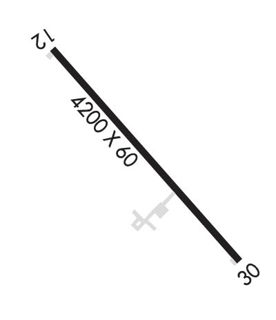
| Lat: N 4655.5 Long: W 10358.9 Elev: 2756 Var: -08 Longest Runway: 4200 | ||
| AWOS: 118.17 CTAF: 122.8 | ||
| ||||||||||||||||||||||||||||||||||||||||||||
| ||||||||||||||||||||||||||||||||||||||||||||
| ||||||||||||||||||||||||||||||||||||||||||||
| Rwy | Rwy | |||||||
| 4200x60 | 4200' | 4200x60 | 4200' | |||||
| Runway ID | Single Wheel | Double Wheel | Double Tandem Wheel | Dual Double Wheel |
| 12/30 | 12,500 | N/A | N/A | N/A |
| These numbers are Advisory and are not limits. The Airport Manager should have more accurate Weight Limits | ||||
 Airport Diagram might not be current. | |
| Facility Name: | BEACH |
| City Name: | BEACH |
| County: | GOLDEN VALLEY |
| State abbrev: | ND |
| State Name: | NORTH DAKOTA |
| Ownership: | PUBLICLY OWNED |
| Use: | OPEN TO THE PUBLIC |
| Owner's Name: | GOLDEN VALLEY CO ARPT AUTH. |
| Address: | P.O. BOX 748 |
| BEACH, ND 58621 | |
| Owner's Phone: | (701) 872-6484; APT AUTH CHAIRMAN - GERRI WEINREIS |
| Manager's Name: | KARL DAVIS; IF AMGR NOT AVBL CALL BOB SCHMELING AT 701-872-6802. |
| Address: | P.O. BOX 748 |
| BEACH, ND 58621 | |
| Phone: | (256) 496-1978 |
| FAA Region: | GREAT LAKES |
| FAA Field Office: | DMA |
| Date | Sunrise | Sunset |
|---|---|---|
| 09/24/21 Friday | 6:45 | 18:50 |
| 09/25/21 Saturday | 6:46 | 18:48 |
| 09/26/21 Sunday | 6:48 | 18:46 |
| 09/27/21 Monday | 6:49 | 18:44 |
| 09/28/21 Tuesday | 6:50 | 18:42 |
| 09/29/21 Wednesday | 6:52 | 18:40 |
| 09/30/21 Thursday | 6:53 | 18:38 |
| 10/01/21 Friday | 6:54 | 18:36 |
| 10/02/21 Saturday | 6:56 | 18:34 |
| 10/03/21 Sunday | 6:57 | 18:32 |
| 10/04/21 Monday | 6:58 | 18:30 |
| 10/05/21 Tuesday | 7:00 | 18:28 |
| 10/06/21 Wednesday | 7:01 | 18:26 |
| 10/07/21 Thursday | 7:03 | 18:24 |
| Airport Attendance Schedule | ON CALL ON CALL ON CALL; AFT HRS CALL 256-496-1978. |
| Airport Status | OPERATIONAL (This Status can change at any time - please check NOTAMS) |
| Airport Lighting Schedule | ACTVT MIRL RY 12/30 & PAPI RYS 12 & 30 - CTAF. |
| Airport Storage Available | Tie Downs |
| Extra Services Available | Crop Dusting |
| Wind Indicator | YES - (lighted) |
| Control Tower | NO |
| CTAF Frequency | 122.800 |
| Unicom Frequency | 122.800; UNICOM UNATNDD. |
| Rotating Beacon Color | CLEAR-GREEN (Light Land Airport) |
| Segmented Circle | YES |
| Landing Fee | NO |
| Airport Inspected | STATE - performed by STATE AERONAUTICAL PERSONNEL |
| Inspection Date | 10/15/2019 |
| Type of Fuel Available | Grade 100LL, JET A (freeze point -40C); -10FUEL SELF SERVICE 24 HR CREDIT CARD ACCESS. |
| Airframe Repair Service | NONE |
| Power Plant Repair Service | NONE |
| Latitude | N4655.5 |
| Longitude | W10358.9 (ESTIMATED) |
| Arpt Elevation | 2755ft (SURVEYED) |
| Magnetic Variation | 08E |
| 1 miles ENE | of BEACH |
| Traffic Pattern Altitude | |
| Sectional Chart | BILLINGS |
| Operations (Reported) | Yearly | Avg. Daily |
|---|---|---|
| General Aviation Transient | 750 | 2 |
| General Aviation Local | 2000 | 5 |
| Air Taxi | 100 | 0 |
| Commerical | 0 | 0 |
| Commuter | 0 | 0 |
| Military | 30 | 0 |
| Aircraft based on Field | |
|---|---|
| General Aviation Singles | 9 |
| General Aviation Multi | 1 |
| Jet Aircraft | 0 |
| General Aviation Helicopters | 0 |
| Military Aircraft | 0 |
| Gliders | 0 |
| Ultralights | 0 |
| FSS on field | NO |
| FSS tie-in | GRAND FORKS |
| FSS Phone | 1-800-WX-BRIEF |
| Who issues Notams | GFK |
| Notam D service at airport | YES |
| ARTCC Name | SALT LAKE CITY |
| Airport Certification | |
| Aircraft Rescue & Firefighting Index | None |
| Airport of Entry | No |
| Custom Landing Rights | No |
| Joint Civil/Military | No |
| Military Landing rights | YES |
| NATIONAL PLAN OF INTEGRATED AIRPORT SYSTEMS (NPIAS) |
| GRANT AGREEMENTS UNDER FAAP/ADAP/AIP |
| ASSURANCES PURSUANT TO TITLE VI, CIVIL RIGHTS ACT OF 1964 |
| CFM SNOW REMOVAL AFT MAJOR WINTER STORM 256-496-1978. |
| DEER ON & INVOF ARPT. |
| FOR CD CTC SALT LAKE ARTCC AT 801-320-2568. |
Airport Communications & Frequencies:
| |||||||||
| Runway: 12 | Runway: 30 | ||
| Mag heading: | 125° | Mag heading: | 305° |
| Rwy Slope: | -.18% Down | Rwy Slope: | .18% Up |
| Approach: | Approach: | ||
| Pattern: | Left Traffic | Pattern: | Left Traffic |
| Markings: | NONPRECISION INSTRUMENT | Markings: | NONPRECISION INSTRUMENT |
| Marking Condition: | GOOD | Marking Condition: | GOOD |
| Arresting Dev: | Arresting Dev: | ||
| Lat & Long: | N4655.7 W10359.3 | Lat. & Long.: | N4655.3 W10358.6 |
| Elev: | 2755.9 ft. MSL | Elev: | 2748.3 ft. MSL |
| TCH: | 26 ft. AGL | TCH: | 27 ft. AGL |
| Visual Glide Path: | 3.00 degrees | Visual Glide Path: | 3.00 degrees |
| Displaced Threshold: | No | Displaced Threshold: | No |
| Touchdown Zone: | YES | Touchdown Zone: | YES |
| Touchdown Elev.: | 2755.9 feet | Touchdown Elev.: | 2754.2 feet |
| Visual Glide Slope: | 2-Light PAPI on LEFT side of Runway | Visual Glide Slope: | 2-Light PAPI on LEFT side of Runway |
| RVR Equipment: | RVR Equipment: | ||
| RVV Equipment: | NO | RVV Equipment: | NO |
| Approach Lights: | Approach Lights: | ||
| REIL: | NO | REIL: | NO |
| Centerline Lights: | NO | Centerline Lights: | NO |
| Touchdown lights: | NO | Touchdown lights: | NO |
| Runway Category: | Runway with a Non-precision Approach | Runway Category: | Runway with a Non-precision Approach |
| Declared Distances: | Declared Distances: | ||
| Obstructions: | Obstructions: | ROAD | |
| Marked: | Marked: | NOT Marked/Lighted | |
| Clearance slope: | 50:1 | Clearance slope: | 21:1 |
| Obstruction height: | Obstruction height: | 22 feet AGL | |
| Dist. from runway: | Dist. from runway: | 675 feet | |
| Centerline offset: | Centerline offset: | 320 feet left of centerline | |
| Comments: | Comments: |
Thanks for using FltPlan.com
all rights reserved © 1999-2021 by Flight Plan LLC
