| FREMONT COUNTY CANON CITY CO |
| |
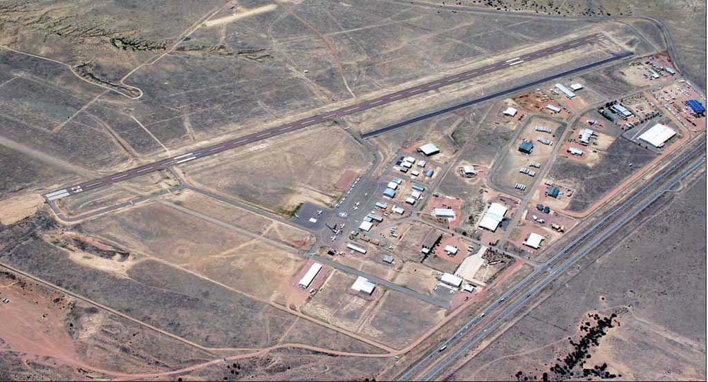
| Lat: N 3825.7 Long: W 10506.4 Elev: 5442 Var: -08 Longest Runway: 5399 | ||
| AWOS: 120.02 CTAF: 122.8 | ||
| |||||||||||||||||||||||||||||||||||||||||||||||||||||||||||||||||||||
| |||||||||||||||||||||||||||||||||||||||||||||||||||||||||||||||||||||
| |||||||||||||||||||||||||||||||||||||||||||||||||||||||||||||||||||||
| |||||||||||||||||||||||||||||||||||||||||||||||||||||||||||||||||||||
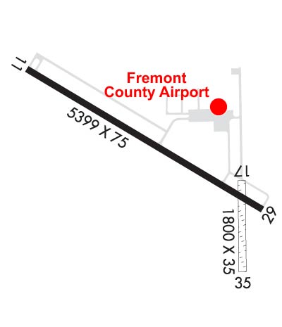
| Rwy | Rwy | |||||||
| 5399x75 | 5399' | 5399x75 | 5399' | |||||
| 1800x35 | 1800' | 1800x35 | 1800' | |||||
| Runway ID | Single Wheel | Double Wheel | Double Tandem Wheel | Dual Double Wheel |
| 11/29 | 26,000 | 26,000 | N/A | N/A |
| 17/35 | N/A | N/A | N/A | N/A |
| These numbers are Advisory and are not limits. The Airport Manager should have more accurate Weight Limits | ||||
 Airport Diagram might not be current. | |
| Facility Name: | FREMONT COUNTY |
| City Name: | CANON CITY |
| County: | FREMONT |
| State abbrev: | CO |
| State Name: | COLORADO |
| Ownership: | PUBLICLY OWNED |
| Use: | OPEN TO THE PUBLIC |
| Owner's Name: | FREMONT COUNTY |
| Address: | 615 MACON |
| CANON CITY, CO 81212 | |
| Owner's Phone: | 719-276-7300 |
| Manager's Name: | WESLEY BRANDT |
| Address: | 60298 HIGHWAY 50 |
| PENROSE, CO 81240 | |
| Phone: | 719-784-3816; AFT HR - 719-429-3816. |
| FAA Region: | NORTHWEST MOUNTAIN |
| FAA Field Office: | DEN |
| Date | Sunrise | Sunset |
|---|---|---|
| 06/07/26 Sunday | 5:37 | 20:22 |
| 06/08/26 Monday | 5:36 | 20:23 |
| 06/09/26 Tuesday | 5:36 | 20:23 |
| 06/10/26 Wednesday | 5:36 | 20:24 |
| 06/11/26 Thursday | 5:36 | 20:24 |
| 06/12/26 Friday | 5:36 | 20:25 |
| 06/13/26 Saturday | 5:36 | 20:25 |
| 06/14/26 Sunday | 5:36 | 20:26 |
| 06/15/26 Monday | 5:36 | 20:26 |
| 06/16/26 Tuesday | 5:36 | 20:26 |
| 06/17/26 Wednesday | 5:36 | 20:27 |
| 06/18/26 Thursday | 5:36 | 20:27 |
| 06/19/26 Friday | 5:36 | 20:27 |
| 06/20/26 Saturday | 5:36 | 20:27 |
| Airport Attendance Schedule | 7 Days A Week 0800-1700 |
| Airport Status | OPERATIONAL (This Status can change at any time - please check NOTAMS) |
| Airport Lighting Schedule | ACTVT REIL RWY 11 & 29; PAPI RWY 11 & 29; MIRL RWY 11/29 - CTAF. |
| Airport Storage Available | Tie Downs, Hanger |
| Extra Services Available | Charter, Flight Instruction, Parachute Jumping, Aircraft Rental |
| Wind Indicator | YES - (lighted) |
| Control Tower | NO |
| CTAF Frequency | 122.800 |
| Unicom Frequency | 122.800 |
| Rotating Beacon Color | WG |
| Segmented Circle | NO |
| Landing Fee | NO |
| Airport Inspected | STATE - performed by STATE AERONAUTICAL PERSONNEL |
| Inspection Date | 05/21/2024 |
| Type of Fuel Available | Grade 100LL, JET A (freeze point -40C) |
| Airframe Repair Service | MAJOR |
| Power Plant Repair Service | MAJOR |
| Latitude | N3825.7 |
| Longitude | W10506.4 (ESTIMATED) |
| Arpt Elevation | 5442ft (SURVEYED) |
| Magnetic Variation | 08E |
| 6 miles E | of CANON CITY |
| Traffic Pattern Altitude | 1058 |
| Sectional Chart | DENVER |
| Operations (Reported) | Yearly | Avg. Daily |
|---|---|---|
| General Aviation Transient | 0 | 0 |
| General Aviation Local | 0 | 0 |
| Air Taxi | 0 | 0 |
| Commerical | 0 | 0 |
| Commuter | 0 | 0 |
| Military | 0 | 0 |
| Aircraft based on Field | |
|---|---|
| General Aviation Singles | 0 |
| General Aviation Multi | 0 |
| Jet Aircraft | 0 |
| General Aviation Helicopters | 0 |
| Military Aircraft | 0 |
| Gliders | 0 |
| Ultralights | 0 |
| FSS on field | NO |
| FSS tie-in | DENVER |
| FSS Phone | 1-800-WX-BRIEF |
| Who issues Notams | DEN |
| Notam D service at airport | YES |
| ARTCC Name | DENVER |
| Airport Certification | |
| Aircraft Rescue & Firefighting Index | None |
| Airport of Entry | No |
| Custom Landing Rights | No |
| Joint Civil/Military | No |
| Military Landing rights | YES |
| NATIONAL PLAN OF INTEGRATED AIRPORT SYSTEMS (NPIAS) |
| GRANT AGREEMENTS UNDER FAAP/ADAP/AIP |
| ASSURANCES PURSUANT TO TITLE VI, CIVIL RIGHTS ACT OF 1964 |
| APRON AREAS LGTD. |
| FOR CD CTC DENVER APCH AT 303-342-1916. |
| PAVED TWYS MKD WITH BLUE & WHITE REFLECTORS. |
| GLDR OPS & TOWING ON & INVOF ARPT. |
| 2 FT TRRN W OF RWY 17/35 & FIRST 250 FT S OF RWY 11/29. |
| CTN: USAF STUDENT TRNG INVOF COLORADO SPRINGS & PUEBLO COLORADO. |
| RWY 17 +32 FT HNGR 1495 FT FM THR 100 FT R OF EXTNDD CNTRLN. |
| RWY 17/3 5 VRBL 35 - 45 FT. |
| RWY 17/3 5 PRARIE DOG HOLES THRUT. |
| RWY 17/3 5 1CROSSES ASPH TWY & RWY. |
Airport Communications & Frequencies:
| |||||||||||||||||
| Runway: 11 | Runway: 29 | ||
| Mag heading: | 113° | Mag heading: | 293° |
| Rwy Slope: | -1.12% Down | Rwy Slope: | 1.12% Up |
| Approach: | Approach: | ||
| Pattern: | Left Traffic | Pattern: | Left Traffic |
| Markings: | NONPRECISION INSTRUMENT | Markings: | PRECISION INSTRUMENT |
| Marking Condition: | FAIR | Marking Condition: | FAIR |
| Arresting Dev: | Arresting Dev: | ||
| Lat & Long: | N3826.0 W10507.0 | Lat. & Long.: | N3825.6 W10506.0 |
| Elev: | 5442.4 ft. MSL | Elev: | 5381.8 ft. MSL |
| TCH: | 23 ft. AGL | TCH: | 40 ft. AGL |
| Visual Glide Path: | 3.00 degrees | Visual Glide Path: | 3.00 degrees |
| Displaced Threshold: | No | Displaced Threshold: | No |
| Touchdown Zone: | YES | Touchdown Zone: | YES |
| Touchdown Elev.: | 5442.4 feet | Touchdown Elev.: | 5407.4 feet |
| Visual Glide Slope: | 2-Light PAPI on LEFT side of Runway | Visual Glide Slope: | 2-Light PAPI on LEFT side of Runway |
| RVR Equipment: | RVR Equipment: | ||
| RVV Equipment: | NO | RVV Equipment: | NO |
| Approach Lights: | Approach Lights: | ||
| REIL: | YES | REIL: | YES |
| Centerline Lights: | NO | Centerline Lights: | NO |
| Touchdown lights: | NO | Touchdown lights: | NO |
| Runway Category: | Runway with a Non-precision Approach having visibility minimums greater than 3/4 mile | Runway Category: | Runway with a Non-precision Approach having visibility minimums greater than 3/4 mile |
| Declared Distances: | Declared Distances: |
| Runway: 17 | Runway: 35 | ||
| Mag heading: | 171° | Mag heading: | 351° |
| Rwy Slope: | -1.24% Down | Rwy Slope: | 1.24% Up |
| Approach: | Approach: | ||
| Pattern: | Left Traffic | Pattern: | Left Traffic |
| Markings: | Markings: | ||
| Marking Condition: | Marking Condition: | ||
| Arresting Dev: | Arresting Dev: | ||
| Lat & Long: | N3825.7 W10506.1 | Lat. & Long.: | N3825.4 W10506.1 |
| Elev: | 5386.4 ft. MSL | Elev: | 5364.0 ft. MSL |
| TCH: | TCH: | ||
| Visual Glide Path: | Visual Glide Path: | ||
| Displaced Threshold: | No | Displaced Threshold: | No |
| Touchdown Zone: | YES | Touchdown Zone: | YES |
| Touchdown Elev.: | 5398.1 feet | Touchdown Elev.: | 5395.7 feet |
| Visual Glide Slope: | Visual Glide Slope: | ||
| RVR Equipment: | RVR Equipment: | ||
| RVV Equipment: | NO | RVV Equipment: | NO |
| Approach Lights: | Approach Lights: | ||
| REIL: | NO | REIL: | NO |
| Centerline Lights: | NO | Centerline Lights: | NO |
| Touchdown lights: | NO | Touchdown lights: | NO |
| Runway Category: | Runway with a Visual Approach | Runway Category: | Runway with a Visual Approach |
| Declared Distances: | Declared Distances: | ||
| Obstructions: | BLDG | Obstructions: | |
| Marked: | NOT Marked/Lighted | Marked: | |
| Clearance slope: | 42:1 | Clearance slope: | 50:1 |
| Obstruction height: | 30 feet AGL | Obstruction height: | |
| Dist. from runway: | 1270 feet | Dist. from runway: | |
| Centerline offset: | 35 left of centerline | Centerline offset: | |
| Comments: | Comments: |
Thanks for using FltPlan.com
all rights reserved © 1999-2026 by Flight Plan LLC