
| BEAR LAKE COUNTY PARIS ID |
| |
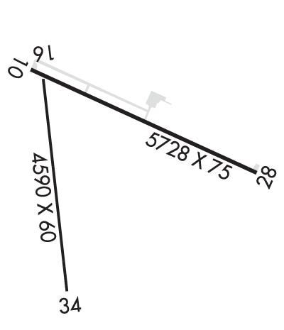
| Lat: N 4215.0 Long: W 11120.5 Elev: 5933 Var: -11 Longest Runway: 5728 | ||
| CTAF: 122.8 | ||
| ||||||
|
| Rwy | Rwy | |||||||
| 5728x75 | 5728' | 5728x75 | 5728' | |||||
| 4590x60 | 4590' | 4590x60 | 4590' | |||||
| Runway ID | Single Wheel | Double Wheel | Double Tandem Wheel | Dual Double Wheel |
| 10/28 | 14,000 | 28,000 | 60,000 | N/A |
| 16/34 | 50,000 | 64,000 | 102,000 | N/A |
| These numbers are Advisory and are not limits. The Airport Manager should have more accurate Weight Limits | ||||
 Airport Diagram might not be current. | |
| Facility Name: | BEAR LAKE COUNTY |
| City Name: | PARIS |
| County: | BEAR LAKE |
| State abbrev: | ID |
| State Name: | IDAHO |
| Ownership: | PUBLICLY OWNED |
| Use: | OPEN TO THE PUBLIC |
| Owner's Name: | BEAR LAKE COUNTY |
| Address: | PO BOX 190 |
| PARIS, ID 83261 | |
| Owner's Phone: | 208-945-2212 |
| Manager's Name: | TREVOR KEETCH |
| Address: | P O BOX 163 |
| MONTPELIER, ID 83254 | |
| Phone: | 208-223-0416; 208-223-0416 CELL, AVBL 24 HRS. |
| FAA Region: | NORTHWEST MOUNTAIN |
| FAA Field Office: | HLN |
| Date | Sunrise | Sunset |
|---|---|---|
| 06/08/26 Monday | 5:49 | 21:00 |
| 06/09/26 Tuesday | 5:49 | 21:01 |
| 06/10/26 Wednesday | 5:49 | 21:01 |
| 06/11/26 Thursday | 5:48 | 21:02 |
| 06/12/26 Friday | 5:48 | 21:02 |
| 06/13/26 Saturday | 5:48 | 21:03 |
| 06/14/26 Sunday | 5:48 | 21:03 |
| 06/15/26 Monday | 5:48 | 21:03 |
| 06/16/26 Tuesday | 5:48 | 21:04 |
| 06/17/26 Wednesday | 5:48 | 21:04 |
| 06/18/26 Thursday | 5:48 | 21:05 |
| 06/19/26 Friday | 5:49 | 21:05 |
| 06/20/26 Saturday | 5:49 | 21:05 |
| 06/21/26 Sunday | 5:49 | 21:05 |
| Airport Attendance Schedule | CONTINUOUS |
| Airport Status | OPERATIONAL (This Status can change at any time - please check NOTAMS) |
| Airport Lighting Schedule | ACTVT REIL RWY 10 & 28; MIRL RWY 10/28 - CTAF. |
| Airport Storage Available | Tie Downs |
| Extra Services Available | NONE |
| Wind Indicator | YES - (lighted) |
| Control Tower | NO |
| CTAF Frequency | 122.800 |
| Unicom Frequency | 122.800 |
| Rotating Beacon Color | WG |
| Segmented Circle | YES |
| Landing Fee | NO |
| Airport Inspected | STATE - performed by STATE AERONAUTICAL PERSONNEL |
| Inspection Date | 04/24/2024 |
| Type of Fuel Available | Grade 100LL; -10100 LL FUEL AVBL 24 HRS WITH CREDIT CARD SELF SVC. |
| Airframe Repair Service | NONE |
| Power Plant Repair Service | NONE |
| Latitude | N4215.0 |
| Longitude | W11120.5 (ESTIMATED) |
| Arpt Elevation | 5932ft (SURVEYED) |
| Magnetic Variation | 11E |
| 3 miles E | of PARIS |
| Traffic Pattern Altitude | |
| Sectional Chart | SALT LAKE CITY |
| Operations (Reported) | Yearly | Avg. Daily |
|---|---|---|
| General Aviation Transient | 0 | 0 |
| General Aviation Local | 0 | 0 |
| Air Taxi | 0 | 0 |
| Commerical | 0 | 0 |
| Commuter | 0 | 0 |
| Military | 0 | 0 |
| Aircraft based on Field | |
|---|---|
| General Aviation Singles | 0 |
| General Aviation Multi | 0 |
| Jet Aircraft | 0 |
| General Aviation Helicopters | 0 |
| Military Aircraft | 0 |
| Gliders | 0 |
| Ultralights | 0 |
| FSS on field | NO |
| FSS tie-in | BOISE |
| FSS Phone | 1-800-WX-BRIEF |
| Who issues Notams | BOI |
| Notam D service at airport | YES |
| ARTCC Name | SALT LAKE CITY |
| Airport Certification | |
| Aircraft Rescue & Firefighting Index | None |
| Airport of Entry | No |
| Custom Landing Rights | No |
| Joint Civil/Military | No |
| Military Landing rights | No |
| NATIONAL PLAN OF INTEGRATED AIRPORT SYSTEMS (NPIAS) |
| GRANT AGREEMENTS UNDER FAAP/ADAP/AIP |
| ASSURANCES PURSUANT TO TITLE VI, CIVIL RIGHTS ACT OF 1964 |
| AGREEMENT UNDER DLAND OR DCLA HAS EXPIRED. |
| BIRDS ON & INVOF OF ARPT. |
| REFLECTORS ON ALL TWYS AND APRONS. |
| PARTIAL TWY 25 FT WIDE. |
| NO SNOW REMOVAL RWY 16/34. |
| FOR CD CTC SALT LAKE ARTCC AT 801-320-2568. |
| COLD TEMPERATURE AIRPORT. ALTITUDE CORRECTION REQUIRED AT OR BELOW -22C. |
| RWY 16/3 4 NO SNOW REMOVAL RWY 16/34. |
Airport Communications & Frequencies:
| |||||||||
| Runway: 10 | Runway: 28 | ||
| Mag heading: | 104° | Mag heading: | 284° |
| Rwy Slope: | .05% Up | Rwy Slope: | -.05% Down |
| Approach: | Approach: | ||
| Pattern: | Left Traffic | Pattern: | Left Traffic |
| Markings: | NONPRECISION INSTRUMENT | Markings: | NONPRECISION INSTRUMENT |
| Marking Condition: | GOOD | Marking Condition: | GOOD |
| Arresting Dev: | Arresting Dev: | ||
| Lat & Long: | N4215.3 W11120.9 | Lat. & Long.: | N4214.9 W11119.7 |
| Elev: | 5930.2 ft. MSL | Elev: | 5932.9 ft. MSL |
| TCH: | 45 ft. AGL | TCH: | 51 ft. AGL |
| Visual Glide Path: | 3.50 degrees | Visual Glide Path: | 3.50 degrees |
| Displaced Threshold: | No | Displaced Threshold: | No |
| Touchdown Zone: | YES | Touchdown Zone: | YES |
| Touchdown Elev.: | 5931.6 feet | Touchdown Elev.: | 5932.9 feet |
| Visual Glide Slope: | 2-Light PAPI on LEFT side of Runway; PAPI UNSUBL BYD 8 NM FM THR DUE TO MOUNTAINOUS TRRN. | Visual Glide Slope: | 2-Light PAPI on LEFT side of Runway |
| RVR Equipment: | RVR Equipment: | ||
| RVV Equipment: | NO | RVV Equipment: | NO |
| Approach Lights: | Approach Lights: | ||
| REIL: | YES | REIL: | YES |
| Centerline Lights: | NO | Centerline Lights: | NO |
| Touchdown lights: | NO | Touchdown lights: | NO |
| Runway Category: | Runway with a Non-precision Approach | Runway Category: | Runway with a Non-precision Approach |
| Declared Distances: | Declared Distances: | ||
| Obstructions: | PLINE | Obstructions: | ROAD |
| Marked: | NOT Marked/Lighted | Marked: | NOT Marked/Lighted |
| Clearance slope: | 38:1 | Clearance slope: | 25:1 |
| Obstruction height: | 60 feet AGL | Obstruction height: | 12 feet AGL |
| Dist. from runway: | 2500 feet | Dist. from runway: | 500 feet |
| Centerline offset: | Centerline offset: | ||
| Comments: | Comments: |
| Runway: 16 | Runway: 34 | ||
| Mag heading: | 164° | Mag heading: | 344° |
| Rwy Slope: | -.01% Down | Rwy Slope: | .01% Up |
| Approach: | Approach: | ||
| Pattern: | Left Traffic | Pattern: | Left Traffic |
| Markings: | BASIC | Markings: | BASIC |
| Marking Condition: | GOOD; RUNWAY 16/34 HAS RUNWAY SIDE STRIPE MARKING | Marking Condition: | GOOD |
| Arresting Dev: | Arresting Dev: | ||
| Lat & Long: | N4215.2 W11120.8 | Lat. & Long.: | N4214.5 W11120.7 |
| Elev: | 5930.0 ft. MSL | Elev: | 5929.6 ft. MSL |
| TCH: | TCH: | ||
| Visual Glide Path: | Visual Glide Path: | ||
| Displaced Threshold: | No | Displaced Threshold: | No |
| Touchdown Zone: | YES | Touchdown Zone: | YES |
| Touchdown Elev.: | 5930.5 feet | Touchdown Elev.: | 5930.1 feet |
| Visual Glide Slope: | Visual Glide Slope: | ||
| RVR Equipment: | RVR Equipment: | ||
| RVV Equipment: | NO | RVV Equipment: | NO |
| Approach Lights: | Approach Lights: | ||
| REIL: | NO | REIL: | NO |
| Centerline Lights: | NO | Centerline Lights: | NO |
| Touchdown lights: | NO | Touchdown lights: | NO |
| Runway Category: | Runway with a Visual Approach | Runway Category: | Runway with a Visual Approach |
| Declared Distances: | Declared Distances: |
Thanks for using FltPlan.com
all rights reserved © 1999-2026 by Flight Plan LLC
