
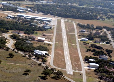
| KESTREL AIRPARK SAN ANTONIO TX |
| |
| Lat: N 2948.7 Long: W 09825.6 Elev: 1261 Var: -07 Longest Runway: 3000 | ||
| CTAF: 122.97 | ||
| ||||||||||||||||||||||||||||||||||||||||||||||||||||||||||||||||||||
| ||||||||||||||||||||||||||||||||||||||||||||||||||||||||||||||||||||
| Rwy | Rwy | |||||||
| 3000x40 | 3000' | 3000x40 | 3000' | |||||
| Runway ID | Single Wheel | Double Wheel | Double Tandem Wheel | Dual Double Wheel |
| 12/30 | N/A | N/A | N/A | N/A |
| These numbers are Advisory and are not limits. The Airport Manager should have more accurate Weight Limits | ||||
| FltPlan does not have IFR approach charts available for K1T7. |
| Facility Name: | KESTREL AIRPARK |
| City Name: | SAN ANTONIO |
| County: | COMAL |
| State abbrev: | TX |
| State Name: | TEXAS |
| Ownership: | PRIVATELY OWNED |
| Use: | OPEN TO THE PUBLIC |
| Owner's Name: | KESTREL AIRPARK RUNWAY ASSOCIATION |
| Address: | 354 FLIGHTLINE |
| SPRING BRANCH, TX 78070 | |
| Owner's Phone: | 210-504-8992 |
| Manager's Name: | BRIAN LLOYD |
| Address: | 354 FLIGHTLINE |
| SPRING BRANCH, TX 78070 | |
| Phone: | 210-504-8992 |
| FAA Region: | SOUTHWEST |
| FAA Field Office: | TEX |
| Date | Sunrise | Sunset |
|---|---|---|
| 06/08/26 Monday | 6:32 | 20:33 |
| 06/09/26 Tuesday | 6:32 | 20:34 |
| 06/10/26 Wednesday | 6:32 | 20:34 |
| 06/11/26 Thursday | 6:32 | 20:34 |
| 06/12/26 Friday | 6:32 | 20:35 |
| 06/13/26 Saturday | 6:32 | 20:35 |
| 06/14/26 Sunday | 6:33 | 20:35 |
| 06/15/26 Monday | 6:33 | 20:36 |
| 06/16/26 Tuesday | 6:33 | 20:36 |
| 06/17/26 Wednesday | 6:33 | 20:36 |
| 06/18/26 Thursday | 6:33 | 20:37 |
| 06/19/26 Friday | 6:33 | 20:37 |
| 06/20/26 Saturday | 6:33 | 20:37 |
| 06/21/26 Sunday | 6:34 | 20:37 |
| Airport Attendance Schedule | CONTINUOUS |
| Airport Status | OPERATIONAL (This Status can change at any time - please check NOTAMS) |
| Airport Lighting Schedule | SS-SR |
| Airport Storage Available | Tie Downs |
| Extra Services Available | Flight Instruction, Aircraft Rental, Aircraft Sales |
| Wind Indicator | YES - (lighted) |
| Control Tower | NO |
| CTAF Frequency | 122.975 |
| Unicom Frequency | 122.975 |
| Rotating Beacon Color | |
| Segmented Circle | YES |
| Landing Fee |
| Airport Inspected | No Inspection Data Available performed by PRIVATE CONTRACT PERSONNEL |
| Inspection Date | 04/26/2026 |
| Type of Fuel Available | Grade 100LL; -10SELF SERV FUEL. FOR ASSISTANCE CALL 830-522-1885. |
| Airframe Repair Service | MAJOR |
| Power Plant Repair Service | MAJOR |
| Latitude | N2948.7 |
| Longitude | W09825.6 (ESTIMATED) |
| Arpt Elevation | 1261ft (ESTIMATED) |
| Magnetic Variation | 07E |
| 23 miles N | of SAN ANTONIO |
| Traffic Pattern Altitude | |
| Sectional Chart | SAN ANTONIO |
| Operations (Reported) | Yearly | Avg. Daily |
|---|---|---|
| General Aviation Transient | 0 | 0 |
| General Aviation Local | 0 | 0 |
| Air Taxi | 0 | 0 |
| Commerical | 0 | 0 |
| Commuter | 0 | 0 |
| Military | 0 | 0 |
| Aircraft based on Field | |
|---|---|
| General Aviation Singles | 0 |
| General Aviation Multi | 0 |
| Jet Aircraft | 0 |
| General Aviation Helicopters | 0 |
| Military Aircraft | 0 |
| Gliders | 0 |
| Ultralights | 0 |
| FSS on field | NO |
| FSS tie-in | SAN ANGELO |
| FSS Phone | 1-800-WX-BRIEF |
| Who issues Notams | SJT |
| Notam D service at airport | YES |
| ARTCC Name | HOUSTON |
| Airport Certification | |
| Aircraft Rescue & Firefighting Index | None |
| Airport of Entry | No |
| Custom Landing Rights | No |
| Joint Civil/Military | No |
| Military Landing rights | No |
| DEER ON & INVOF RWY. |
| TGL AND LOW APCHS PROHIBITED FOR TRAN & COML ACFT. TKOFS RSTRD BTN 2200-0600. |
| HEL TRNG OPS PROHIBITED. |
| FOR CD CTC SAN ANTONIO APCH AT 210-805-5516. |
| USE EXTREME CTN FOR MIL ACFT FROM RANDOLPH AFB AT OR ABV 3000 FT MSL MON-FRI 1600-0600Z++ AND WHEN TWR HRS EXTD BY NOTAM, OCNL SAT AND SUN. |
| RWY 12 120' RISING TERRAIN 0.4 MI NW OF RWY END. NSTD AIMING POINT MKGS AT 500 FT, 2490 FT REMAINING. |
| RWY 12 CALM WIND RWY. |
| RWY 12/30 NOW MARKED AS 13/31 |
| RWY 30 NSTD AIMING POINT MKGS AT 300 FT. |
| RWY 12/3 0 RWY 30 RISES RAPIDLY AT NORTH END. 12 END 49 FT HIGHER THAN 30 END. |
| Runway: 12 | Runway: 30 | ||
| Mag heading: | 121° | Mag heading: | 301° |
| Rwy Slope: | -1.43% Down | Rwy Slope: | 1.43% Up |
| Approach: | Approach: | ||
| Pattern: | Left Traffic | Pattern: | Right Traffic |
| Markings: | BASIC | Markings: | BASIC |
| Marking Condition: | GOOD | Marking Condition: | GOOD |
| Arresting Dev: | Arresting Dev: | ||
| Lat & Long: | N2948.9 W09825.8 | Lat. & Long.: | N2948.6 W09825.3 |
| Elev: | 1261.0 ft. MSL | Elev: | 1218.0 ft. MSL |
| TCH: | TCH: | ||
| Visual Glide Path: | Visual Glide Path: | ||
| Displaced Threshold: | No | Displaced Threshold: | No |
| Touchdown Zone: | NO | Touchdown Zone: | NO |
| Touchdown Elev.: | Touchdown Elev.: | ||
| Visual Glide Slope: | Visual Glide Slope: | ||
| RVR Equipment: | RVR Equipment: | ||
| RVV Equipment: | NO | RVV Equipment: | NO |
| Approach Lights: | Approach Lights: | ||
| REIL: | NO | REIL: | NO |
| Centerline Lights: | NO | Centerline Lights: | NO |
| Touchdown lights: | NO | Touchdown lights: | NO |
| Runway Category: | Runway with a Visual Approach | Runway Category: | Runway with a Visual Approach |
| Declared Distances: | Declared Distances: | ||
| Obstructions: | TREES | Obstructions: | ROAD |
| Marked: | NOT Marked/Lighted | Marked: | NOT Marked/Lighted |
| Clearance slope: | 6:1 | Clearance slope: | |
| Obstruction height: | 15 feet AGL | Obstruction height: | 15 feet AGL |
| Dist. from runway: | 300 feet | Dist. from runway: | 200 feet |
| Centerline offset: | 30 left of centerline | Centerline offset: | 125 feet right of centerline |
| Comments: | 15 FT RD 0 FT DSTC 65 FT L; 30 FT TREE 80 FT DSTC, 45 FT L. | Comments: | 15 FT RD 0 FT DSTC 67 FT L. |
Thanks for using FltPlan.com
all rights reserved © 1999-2026 by Flight Plan LLC


