
| LODI AIRPORT LODI CA |
| |
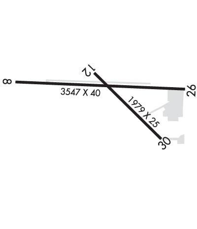
| Lat: N 3812.1 Long: W 12116.1 Elev: 60 Var: -16 Longest Runway: 3547 | ||
| CTAF: 122.9 | ||
| ||||||||||||||||||||||||||||||||||||||||||||
| ||||||||||||||||||||||||||||||||||||||||||||
| Rwy | Rwy | |||||||
| 3547x40 | 3032' | 3547x40 | 3159' | |||||
| 1979x25 | 1797' | 1979x25 | 1877' | |||||
| Runway ID | Single Wheel | Double Wheel | Double Tandem Wheel | Dual Double Wheel |
| 08/26 | 30,000 | N/A | N/A | N/A |
| 12/30 | 30,000 | N/A | N/A | N/A |
| These numbers are Advisory and are not limits. The Airport Manager should have more accurate Weight Limits | ||||
 Airport Diagram might not be current. | |
| Facility Name: | LODI |
| City Name: | LODI |
| County: | SAN JOAQUIN |
| State abbrev: | CA |
| State Name: | CALIFORNIA |
| Ownership: | PRIVATELY OWNED |
| Use: | OPEN TO THE PUBLIC |
| Owner's Name: | ROBERT KUPKA |
| Address: | P.O. BOX 10 |
| ACAMPO, CA 95220 | |
| Owner's Phone: | 209-369-9126 |
| Manager's Name: | ROBERT KUPKA |
| Address: | 23987 NORTH HWY 99 |
| ACAMPO, CA 95220 | |
| Phone: | 209-369-9126 |
| FAA Region: | WESTERN-PACIFIC |
| FAA Field Office: | SFO |
| Date | Sunrise | Sunset |
|---|---|---|
| 06/08/26 Monday | 5:42 | 20:27 |
| 06/09/26 Tuesday | 5:42 | 20:27 |
| 06/10/26 Wednesday | 5:41 | 20:28 |
| 06/11/26 Thursday | 5:41 | 20:28 |
| 06/12/26 Friday | 5:41 | 20:29 |
| 06/13/26 Saturday | 5:41 | 20:29 |
| 06/14/26 Sunday | 5:41 | 20:30 |
| 06/15/26 Monday | 5:41 | 20:30 |
| 06/16/26 Tuesday | 5:41 | 20:30 |
| 06/17/26 Wednesday | 5:41 | 20:31 |
| 06/18/26 Thursday | 5:42 | 20:31 |
| 06/19/26 Friday | 5:42 | 20:31 |
| 06/20/26 Saturday | 5:42 | 20:31 |
| 06/21/26 Sunday | 5:42 | 20:32 |
| Airport Attendance Schedule | 7 Days A Week 0900-DUSK |
| Airport Status | OPERATIONAL (This Status can change at any time - please check NOTAMS) |
| Airport Lighting Schedule | SS-SR |
| Airport Storage Available | Tie Downs |
| Extra Services Available | Flight Instruction, Parachute Jumping, Aircraft Rental, Aircraft Sales, Annual Surveying |
| Wind Indicator | YES - (unlit) |
| Control Tower | NO |
| CTAF Frequency | 122.900 |
| Unicom Frequency | |
| Rotating Beacon Color | WG |
| Segmented Circle | YES |
| Landing Fee | NO |
| Airport Inspected | STATE - performed by STATE AERONAUTICAL PERSONNEL |
| Inspection Date | 03/25/2025 |
| Type of Fuel Available | Grade 100LL, JET A (freeze point -40C); -10AUTOMATED CREDIT CARD FUEL SYSTEM 24 HRS DAY. |
| Airframe Repair Service | MAJOR |
| Power Plant Repair Service | MAJOR |
| Latitude | N3812.1 |
| Longitude | W12116.1 (ESTIMATED) |
| Arpt Elevation | 59ft (SURVEYED) |
| Magnetic Variation | 16E |
| 4 miles N | of LODI |
| Traffic Pattern Altitude | 800 |
| Sectional Chart | SAN FRANCISCO |
| Operations (Reported) | Yearly | Avg. Daily |
|---|---|---|
| General Aviation Transient | 0 | 0 |
| General Aviation Local | 0 | 0 |
| Air Taxi | 0 | 0 |
| Commerical | 0 | 0 |
| Commuter | 0 | 0 |
| Military | 0 | 0 |
| Aircraft based on Field | |
|---|---|
| General Aviation Singles | 0 |
| General Aviation Multi | 0 |
| Jet Aircraft | 0 |
| General Aviation Helicopters | 0 |
| Military Aircraft | 0 |
| Gliders | 0 |
| Ultralights | 0 |
| FSS on field | NO |
| FSS tie-in | RANCHO MURIETA |
| FSS Phone | 1-800-WX-BRIEF |
| Who issues Notams | RIU |
| Notam D service at airport | YES |
| ARTCC Name | OAKLAND |
| Airport Certification | |
| Aircraft Rescue & Firefighting Index | None |
| Airport of Entry | No |
| Custom Landing Rights | No |
| Joint Civil/Military | No |
| Military Landing rights | No |
| PARACHUTE DROP ZONE LOCATED APPROXIMATLY 1000' SOUTH OF RWY 08/26. |
| FOR CD CTC NORCAL APCH AT 916-361-0516. |
| RWY 08/2 6 RWY 08/26 NSTD LIRL LCTD 30 FT FM PAVEMENT EDGE. END OF RUNWAY LIGHTS LOCATED AT BOTH DISPLACED THRESHOLDS TO RUNWAY 8/26. |
Airport Communications & Frequencies:
| ||||||||||||||||
| Runway: 08 | Runway: 26 | ||
| Mag heading: | 76° | Mag heading: | 256° |
| Rwy Slope: | .12% Up | Rwy Slope: | -.12% Down |
| Approach: | Approach: | ||
| Pattern: | Left Traffic | Pattern: | Right Traffic |
| Markings: | BASIC | Markings: | BASIC |
| Marking Condition: | GOOD | Marking Condition: | GOOD |
| Arresting Dev: | Arresting Dev: | ||
| Lat & Long: | N3812.2 W12116.6 | Lat. & Long.: | N3812.2 W12115.8 |
| Elev: | 55.6 ft. MSL | Elev: | 59.9 ft. MSL |
| TCH: | TCH: | ||
| Visual Glide Path: | Visual Glide Path: | ||
| Displaced Threshold: | 515 feet | Displaced Threshold: | 388 feet |
| Touchdown Zone: | YES | Touchdown Zone: | YES |
| Touchdown Elev.: | 57.3 feet | Touchdown Elev.: | 59.2 feet |
| Visual Glide Slope: | Visual Glide Slope: | ||
| RVR Equipment: | RVR Equipment: | ||
| RVV Equipment: | NO | RVV Equipment: | NO |
| Approach Lights: | Approach Lights: | ||
| REIL: | NO | REIL: | NO |
| Centerline Lights: | NO | Centerline Lights: | NO |
| Touchdown lights: | NO | Touchdown lights: | NO |
| Runway Category: | Runway with a Visual Approach | Runway Category: | Runway with a Visual Approach |
| Declared Distances: | Declared Distances: | ||
| Obstructions: | POLE | Obstructions: | POLE |
| Marked: | NOT Marked/Lighted | Marked: | NOT Marked/Lighted |
| Clearance slope: | 1:1; RWY 8 APCH RATIO 17:1 FROM DSPLCD THR. | Clearance slope: | 4:1; APCH RATIO 27:1 FM DSPLCD THR; APCH RATIO FM DSPLCD THR TO +58 FT ANTENNA 1400 FT FM DSPLCD THR 24:1. |
| Obstruction height: | 35 feet AGL | Obstruction height: | 30 feet AGL |
| Dist. from runway: | 50 feet | Dist. from runway: | 340 feet |
| Centerline offset: | 165 right of centerline | Centerline offset: | 90 feet left of centerline |
| Comments: | RWY 8 35 FT POLE 100 FT FM RSY END 165 FT RIGHT. | Comments: | RY 26 +15' FRONTAGE ROAD 110 FM RY END AND +20' FREEWAY 150' FM RY END. ALL 125' R - 125' L. |
| Runway: 12 | Runway: 30 | ||
| Mag heading: | 119° | Mag heading: | 299° |
| Rwy Slope: | .04% Up | Rwy Slope: | -.04% Down |
| Approach: | Approach: | ||
| Pattern: | Right Traffic | Pattern: | Left Traffic |
| Markings: | NUMBERS ONLY | Markings: | NUMBERS ONLY |
| Marking Condition: | FAIR | Marking Condition: | FAIR |
| Arresting Dev: | Arresting Dev: | ||
| Lat & Long: | N3812.2 W12116.2 | Lat. & Long.: | N3812.0 W12115.9 |
| Elev: | 57.5 ft. MSL | Elev: | 58.2 ft. MSL |
| TCH: | TCH: | ||
| Visual Glide Path: | Visual Glide Path: | ||
| Displaced Threshold: | 182 feet | Displaced Threshold: | 102 feet |
| Touchdown Zone: | YES | Touchdown Zone: | YES |
| Touchdown Elev.: | 58.6 feet | Touchdown Elev.: | 58.6 feet |
| Visual Glide Slope: | Visual Glide Slope: | ||
| RVR Equipment: | RVR Equipment: | ||
| RVV Equipment: | NO | RVV Equipment: | NO |
| Approach Lights: | Approach Lights: | ||
| REIL: | NO | REIL: | NO |
| Centerline Lights: | NO | Centerline Lights: | NO |
| Touchdown lights: | NO | Touchdown lights: | NO |
| Runway Category: | Runway with a Visual Approach | Runway Category: | Runway with a Visual Approach |
| Declared Distances: | Declared Distances: | ||
| Obstructions: | TREE | Obstructions: | TREE |
| Marked: | NOT Marked/Lighted | Marked: | NOT Marked/Lighted |
| Clearance slope: | 13:1 | Clearance slope: | 13:1; RWY 30 APCH RATIO 20:1 FROM DSPLCD THR. |
| Obstruction height: | 35 feet AGL | Obstruction height: | 40 feet AGL |
| Dist. from runway: | 660 feet | Dist. from runway: | 750 feet |
| Centerline offset: | 80 right of centerline | Centerline offset: | 160 feet left of centerline |
| Comments: | RY 12 +15 FT ROAD 125 FT-150 FT FM RWY END 25 FT RIGHT 75 FT LEFT. | Comments: |
Thanks for using FltPlan.com
all rights reserved © 1999-2026 by Flight Plan LLC
